
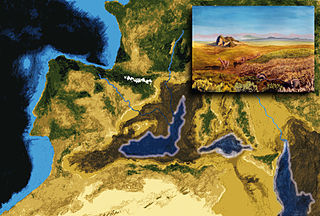
The Dead Sea, also known by other names, is a landlocked salt lake bordered by Jordan to the east and the Israeli-occupied West Bank and Israel to the west. It lies in the Jordan Rift Valley, and its main tributary is the Jordan River.

An evaporite is a water-soluble sedimentary mineral deposit that results from concentration and crystallization by evaporation from an aqueous solution. There are two types of evaporite deposits: marine, which can also be described as ocean deposits, and non-marine, which are found in standing bodies of water such as lakes. Evaporites are considered sedimentary rocks and are formed by chemical sediments.
The Messinian salinity crisis was a geological event during which the Mediterranean Sea went into a cycle of partial or nearly complete desiccation (drying-up) throughout the latter part of the Messinian age of the Miocene epoch, from 5.96 to 5.33 Ma. It ended with the Zanclean flood, when the Atlantic reclaimed the basin.

The geology of the Falkland Islands is described in several publications. The Falkland Islands are located on a projection of the Patagonian continental shelf. In ancient geological time this shelf was part of Gondwana, which around 400 million years ago broke from what is now Africa and drifted westwards relative to Africa. Studies of the seabed surrounding the islands indicated the possibility of oil. Intensive exploration began in 1996, although there had been some earlier seismic surveys in the region.

In geology, a terrace is a step-like landform. A terrace consists of a flat or gently sloping geomorphic surface, called a tread, that is typically bounded on one side by a steeper ascending slope, which is called a "riser" or "scarp". The tread and the steeper descending slope together constitute the terrace. Terraces can also consist of a tread bounded on all sides by a descending riser or scarp. A narrow terrace is often called a bench.

A lacustrine plain or lake plain is a plain formed due to the past existence of a lake and its accompanying sediment accumulation. Lacustrine plains can be formed through one of three major mechanisms: glacial drainage, differential uplift, and inland lake creation and drainage. Lake plains can have various uses depending on where and how they form.
The geology of Saskatchewan can be divided into two main geological regions, the Precambrian Canadian Shield and the Phanerozoic Western Canadian Sedimentary Basin. Within the Precambrian shield exists the Athabasca sedimentary basin. Meteorite impacts have altered the natural geological formation processes. The prairies were most recently affected by glacial events in the Quaternary period.
In geology, the Paradox Formation Is a Pennsylvanian age formation which consists of abundant evaporites with lesser interbedded shale, sandstone, and limestone. The evaporites are largely composed of gypsum, anhydrite, and halite. The formation is found mostly in the subsurface, but there are scattered exposures in anticlines in eastern Utah and western Colorado. These surface exposures occur in the Black Mesa, San Juan and Paradox Basins and the formation is found in the subsurface in southwestern Colorado, southeastern Utah, northeastern Arizona and northeastern New Mexico.
Lake Beisan was a prehistoric lake that existed from ca. 12,000 to 5,000 BC in the north of the Jordan Valley in the Near East near modern-day Beit She'an.
The Epoch of Extreme Inundations (EEI) is a hypothetical epoch during which four landforms in the Pontic–Caspian steppe—marine lowlands, river valleys, marine transgressions and slopes —were widely inundated. Catastrophic events during the epoch are theorized to have influenced prehistoric human life.

The Arauco Basin is a sediment-filled depression –a sedimentary basin– in south-central Chile. In the context of plate tectonics it is classified as a forearc basin. The basin has an approximate area of 8,000 square kilometres (3,100 sq mi) and at its deeper parts the surface of its sedimentary fill reaches 200 metres (660 ft) below sea-level. The basin is interpreted as being part of an uplifted part of the continental shelf. To the west it bounds an active accretionary prism that lies next to the Chile trench and to the east it bounds metamorphic basement representing a fossil Paleozoic accretionary complex that has been intruded by the Coastal Batholith of central Chile.

Lake Cahuilla was a prehistoric lake in California and northern Mexico. Located in the Coachella and Imperial valleys, it covered surface areas of 5,700 km2 (2,200 sq mi) to a height of 12 m (39 ft) above sea level during the Holocene. During earlier stages of the Pleistocene, the lake reached even higher elevations, up to 31–

Lake Manly was a pluvial lake in Death Valley, California, covering much of Death Valley with a surface area of 1,600 square kilometres (620 sq mi) during the so-called "Blackwelder stand". Water levels varied through its history, and the chronology is further complicated by active tectonic processes that have modified the elevations of the various shorelines of Lake Manly; during the Blackwelder stage they reached 47–90 metres (154–295 ft) above sea level. The lake received water mainly from the Amargosa River and at various points from the Mojave River and Owens River. The lake and its substantial catchment favoured the spread of a number of aquatic species, including some lizards, pupfish and springsnails. The lake probably supported a substantial ecosystem, and a number of diatoms developed there.

The Sabana Formation is a geological formation of the Bogotá savanna, Altiplano Cundiboyacense, Eastern Ranges of the Colombian Andes. The formation consists mainly of shales with at the edges of the Bogotá savanna lignites and sandstones. The Sabana Formation dates to the Quaternary period; Middle to Late Pleistocene epoch, and has a maximum thickness of 320 metres (1,050 ft), varying greatly across the savanna. It is the uppermost formation of the lacustrine and fluvio-glacial sediments of paleolake Humboldt, that existed at the edge of the Eastern Hills until the latest Pleistocene.

The geology of Lebanon remains poorly studied prior to the Jurassic. The country is heavily dominated by limestone, sandstone, other sedimentary rocks, and basalt, defined by its tectonic history. In Lebanon, 70% of exposed rocks are limestone karst.
The geology of Malawi formed on extremely ancient crystalline basement rock, which was metamorphosed and intruded by igneous rocks during several orogeny mountain building events in the past one billion years. The rocks of the Karoo Supergroup and newer sedimentary units deposited across much of Malawi in the last 251 million years, in connection with a large rift basin on the supercontinent Gondwana and the more recent rifting that has created the East African Rift, which holds Lake Malawi. The country has extensive mineral reserves, many of them poorly understood or not exploited, including coal, vermiculite, rare earth elements and bauxite.

Lake Panamint is a former lake that occupied Panamint Valley in California during the Pleistocene. It was formed mainly by water overflowing through the Owens River and which passed through Lake Searles into the Panamint Valley. At times, Lake Panamint itself overflowed into Death Valley and Lake Manly.
The geology of Jordan includes thick sedimentary sequences of sandstone, marl and evaporites atop ancient Precambrian crystalline igneous and metamorphic basement rock.

The geology of Italy includes mountain ranges such as the Alps and the Apennines formed from the uplift of igneous and primarily marine sedimentary rocks all formed since the Paleozoic. Some active volcanoes are located in Insular Italy.
Lake San Agustín is a former lake in New Mexico, which developed as a pluvial lake in the Plains of San Agustín during Pleistocene glacial periods. During its highstands it covered an area of 1,200 square kilometres (460 sq mi) with a maximum depth of 70 metres (230 ft), and split into several separate lakes while drying out. The lake last appeared during the last glacial maximum (LGM) and dried out at the beginning of the Holocene, with the last remnant disappearing about 5,000 years ago.
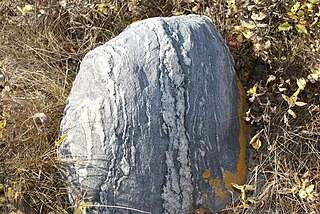
 Formations left by Lake Lisan next to the Allenby Bridge
 The remains of Lake Lisan by the roadside
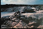 Formations of Lake Lisan
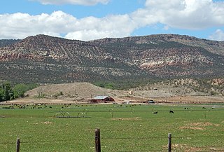
 Sediment build up by the Dead Sea


