
West Adams is a neighborhood in the South Los Angeles region of Los Angeles, California. The neighborhood is known for its large number of historic buildings, structures, notable houses, and mansions. It contains several Historic Preservation Overlay Zones as well as designated historic districts.
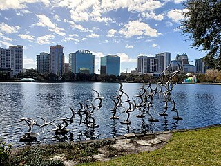
Downtown Orlando is the historic core and central business district of Orlando, Florida, United States. It is bordered by Marks Street in the north, Mills Avenue in the east, Orange Blossom Trail in the west, and Kaley Avenue in the south. There are several distinct neighborhoods in downtown; "North Quarter" to the north, "Lake Eola Heights Historic District" just north of Lake Eola, "South Eola" contains Lake Eola Park and continues to the east and south of Lake Eola, "Thornton Park" in the east, "Parramore" in the west, "Lake Cherokee Historic District" to the south, and the "Central Business District" between Colonial Drive and Lake Lucerne in the center. In 2010, the estimated population of downtown was 18,731. The daytime population was estimated to be 65,000. The 5-mile radius population of downtown is 273,335.

Minneapolis is officially defined by its city council as divided into 83 neighborhoods. The neighborhoods are historically grouped into 11 communities. Informally, there are city areas with colloquial labels. Residents may also group themselves by their city street suffixes: North, Northeast, South, and Southeast.

Angelino Heights, alternately spelled Angeleno Heights, is one of the oldest neighborhoods in Los Angeles. Situated between neighboring Chinatown and Echo Park, the neighborhood is known for its concentration of eclectic architectural styles from three eras: Victorian, Turn of the Century and Revival. Carroll Avenue is listed on the National Register of Historic Places and there are over thirty Historic-Cultural Monuments in the neighborhood.

University Heights is a neighborhood in San Diego, California, centered on Park Boulevard and Adams Avenue. University Heights is bounded on the west and north by the edge of the mesa overlooking Mission Valley, the southern boundary is Lincoln Avenue, and the eastern boundary is Texas Street.

The Old West Austin Historic District is a residential community in Austin, Texas, United States. It is composed of three neighborhoods located on a plateau just west of downtown Austin: Old Enfield, Pemberton Heights, and Bryker Woods. Developed between 1886 and 1953, the three historic neighborhoods stretch from Mopac Expressway east to Lamar Boulevard, and from 13th Street north to 35th Street. It borders Clarksville Historic District and the West Line Historic District to the south.
The Grandview Heights Historic District is a U.S. historic district located in West Palm Beach, Florida. The district is bounded by Park Place, Alabama Avenue, M Street, and Lake Avenue.

The Seminole Heights Residential District, known also as the Seminole Heights Historic District, is a U.S. and Local Historic District located in Tampa, Florida. The district is roughly bounded by Hanna Avenue to the north, Cherokee Avenue and I-275 to the east, Florida Avenue to the west, and Osborne Avenue to the south.

Sunset Heights is a historic area in El Paso, Texas that has existed since the latter part of the 1890s. Many wealthy residents have had their houses and mansions built on this hill. Although some buildings have been renovated to their former glory, many have been neglected and have deteriorated. An organization, the Sunset Heights Improvement Association, helps neighbors on a fixed income to manage home maintenance and also sponsors an annual tour.
Mount Morris Park Historic District is a 16-block historic district in west central Harlem, Manhattan, New York City. It was designated by the New York City Landmarks Preservation Commission in 1971, and is part of the larger Mount Morris Park neighborhood. The boundaries are West 118th and West 124th Streets, Fifth Avenue, and Adam Clayton Powell Jr. Boulevard.

The Kenilworth Avenue Historic District is a historic district in the northwestern portion of Dayton, Ohio, United States. Composed largely of houses constructed after the Great Flood of 1913, the district features examples of several prominent architectural styles, and it has received both local and federal recognition.

Glen Echo is a neighborhood located in the far northern part of the University District in Columbus, Ohio. The area was listed on the National Register of Historic Places in 1997. The name Glen Echo refers to Glen Echo Ravine, which runs along the northern edge of the neighborhood. Principal streets in the area are Glen Echo Drive, Summit Street, Glenmawr Avenue, North Fourth Street, Arcadia, Cliffside Drive, and more. One street, Parkview Drive, was platted in the ravine basin, but was later abandoned.
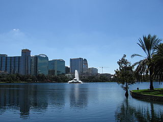
Lake Eola Park is a public park located in Downtown Orlando, Florida. Lake Eola is the main feature of the park. Also located in the park is the Walt Disney Amphitheater, which hosts many community events and various performances year round. On the east side of the park is a Chinese pagoda, and a playground. The park is surrounded by four streets: East Robinson Street, Rosalind Avenue, East Central Boulevard, and North Eola Drive.

The neighborhoods of Albany, New York are listed below.

Normandie Heights is a neighborhood in Pasadena, California. It is bordered by Woodbury Road to the north, Washington Boulevard to the south, Los Robles Avenue to the west, and Lake Avenue to the east. While the exterior of many older homes in Southern California have been coated with stucco, Normandie is distinguished by a high concentration of Craftsman homes with well-maintained wooden exteriors. Accordingly, the City of Pasadena has designated more than 50 homes in the neighborhood as architectural landmarks, many on Rio Grande Street, between Los Robles Avenue and El Molino Avenue, which was the site of the first residences in the neighborhood.

Forest Park is a Victorian garden district located in Springfield, Massachusetts, developed between 1880 and 1920. It is the city's most populous neighborhood, and surrounds the 735-acre Forest Park, for which the neighborhood is named. The Forest Park neighborhood has nature and recreation within walking distance. To the west, I-91 separates Forest Park from the Connecticut River. A 195-acre section of the neighborhood was listed on the National Register of Historic Places in 1982 as the Forest Park Heights Historic District.
There are several neighborhoods in the city of Pasadena, California


