Mali is located in Africa. The history of the territory of modern Mali may be divided into:

The economy of Mali is based to a large extent upon agriculture, with a mostly rural population engaged in subsistence agriculture.
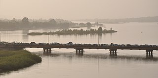
The Niger River is the main river of West Africa, extending about 4,180 kilometres. Its drainage basin is 2,117,700 km2 (817,600 sq mi) in area. Its source is in the Guinea Highlands in south-eastern Guinea near the Sierra Leone border. It runs in a crescent shape through Mali, Niger, on the border with Benin and then through Nigeria, discharging through a massive delta, known as the Niger Delta, into the Gulf of Guinea in the Atlantic Ocean. The Niger is the third-longest river in Africa, exceeded by the Nile and the Congo River. Its main tributary is the Benue River.

The Sahel region or Sahelian acacia savanna is a biogeographical region in Africa. It is the transition zone between the more humid Sudanian savannas to its south and the drier Sahara to the north. The Sahel has a hot semi-arid climate and stretches across the southernmost latitudes of North Africa between the Atlantic Ocean and the Red Sea. Although geographically located in the tropics, the Sahel does not have a tropical climate.
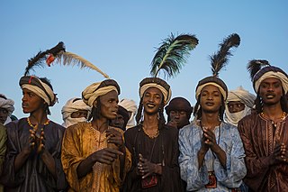
The Fula, Fulani, or Fulɓe people are an ethnic group in Sahara, Sahel and West Africa, widely dispersed across the region. Inhabiting many countries, they live mainly in West Africa and northern parts of Central Africa, South Sudan, Darfur, and regions near the Red Sea coast in Sudan. The approximate number of Fula people is unknown, due to clashing definitions regarding Fula ethnicity. Various estimates put the figure between 25 and 40 million people worldwide.

Timbuktu is an ancient city in Mali, situated 20 kilometres north of the Niger River. It is the capital of the Tombouctou Region, one of the eight administrative regions of Mali, having a population of 54,453 in the 2009 census.

The Songhai people are an ethnolinguistic group in West Africa who speak the various Songhai languages. Their history and lingua franca is linked to the Songhai Empire which dominated the western Sahel in the 15th and 16th century. Predominantly adherents of Islam, the Songhai are primarily located in Niger and Mali. Historically, the term "Songhai" did not denote an ethnic or linguistic identity but referred to the ruling caste of the Songhay Empire known as the Songhaiborai. However, the correct term used to refer to this group of people collectively by the natives is "Ayneha". Although some speakers in Mali have also adopted the name Songhay as an ethnic designation, other Songhay-speaking groups identify themselves by other ethnic terms such as Zarma or Isawaghen. The dialect of Koyraboro Senni spoken in Gao is unintelligible to speakers of the Zarma dialect of Niger, according to at least one report. The Songhay languages are commonly taken to be Nilo-Saharan but this classification remains controversial: Dimmendaal (2008) believes that for now it is best considered an independent language family.

Gao, or Gawgaw/Kawkaw, is a city in Mali and the capital of the Gao Region. The city is located on the River Niger, 320 km (200 mi) east-southeast of Timbuktu on the left bank at the junction with the Tilemsi valley.

Ségou is a town and an urban commune in south-central Mali that lies 235 kilometres (146 mi) northeast of Bamako on the right bank of the River Niger. The town is the capital of the Ségou Cercle and the Ségou Region. With 130,690 inhabitants in 2009, it is the fifth-largest town in Mali.
Gossi is a town and rural commune in the Cercle of Gourma-Rharous of the Tombouctou Region of Mali, lying northeast of Hombori and southwest of Gao. The town is just to the west of the main RN15 highway that links Mopti with Gao. It is on a seasonal lake, Mare de Gossi, and is surrounded by nature reserves in which a large herd of elephants live. The town is the site of a large cattle market. The commune contains around 31 villages and in the 2009 census, it had a population of 24,521. Around 90% of the population are nomadic pastoralists but there are permanent settlements around Lake Gossi, Lake Ebanguemalène and Lake Agoufou.

Azawad, or Azawagh, was a short-lived unrecognised state lasting between 2012 and 2013. Azawagh (Azawaɣ) is the generic Tuareg Berber name for all Tuareg Berber areas, especially the northern half of Mali and northern and western Niger. The Azawadi declaration of independence was declared unilaterally by the National Movement for the Liberation of Azawad (MNLA) in 2012, after a Tuareg rebellion drove the Malian Armed Forces from the region.
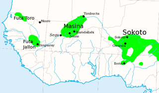
The Caliphate of Hamdullahi, commonly known as the Massina empire, was an early nineteenth-century Sunni Muslim caliphate in West Africa centered in the Inner Niger Delta of what is now the Mopti and Ségou Regions of Mali. It was founded by Seku Amadu in 1818 during the Fulani jihads after defeating the Bambara Empire and its allies at the Battle of Noukouma. By 1853, the empire had fallen into decline and was ultimately destroyed by Omar Saidou Tall of Toucouleur.
Amadu II of Massina, also called Amadu Seku, was the second Almami, or ruler, of the theocratic Caliphate of Hamdullahi or Diina of Hamdullahi in what is now Mali. He held this position from 1845 until his death in 1853. His rule was a short period of relative peace and prosperity between the violent reigns of his father and his son.
Goundam is a commune and town in north central Mali, in the Tombouctou Region. It is the capital of Goundam Cercle, one of five subdivisions of the Region. In the 2009 census the commune had a population of 16,253. The main ethnic groups are Songhay, Tuareg and Fulani.

Lake Débo is a lake in the central part of Mali, formed by the seasonal flooding of the Niger River basin. It is in the Inner Niger Delta of the Niger River. During high water stages of the river, the delta formed by lakes, creeks, and backwaters form part of Lake Débo. The inner delta has many wide channels, which are shallow and flooded marshes; this delta extends over a length of 320 kilometres with a width of 80 km (50 mi). Lake Débo during high flow season, is at a distance of 80 km (50 mi) from Mopti on its upstream, on the southern end and 240 km (150 mi) from Timbuktu at its downstream, on the north-eastern end. It is the largest of many such seasonal wetlands and lakes which form the Inner Niger Delta, and the largest lake within Mali. Its size is largely reduced during the dry season of September to March. The existence of this lake called the "Great Lake" in the inner delta of Niger River between Jenne and Timbuktu in Mali has been established after extensive study of maps of the region extending over a period from 1000 to 1900 AD; 400 maps were studied for the period.

Gourma-Rharous Cercle is an administrative subdivision of the Tombouctou Region of Mali. The administrative center is the town of Gourma-Rharous.
Liptako is an historic region of West Africa. It today falls in eastern Burkina Faso, southwestern Niger and a small portion of southeast central Mali. A hilly region beginning on the right back of the Niger river, Liptako is usually associated with the Liptako Emirate, an early 19th-century Fulani Islamic state, founded by Brahima Saidu. A modern remnant of the emirate continues to exist as a non-sovereign monarchy. The current emir, Ousmane Amirou Dicko, lives in Dori.

Koyraboro Senni is a member of the Songhay languages of Mali and is spoken by some 400,000 people along the Niger River from the town of Gourma-Rharous, east of Timbuktu, through Bourem, Gao and Ansongo to the Mali–Niger border.

Desert elephants or desert-adapted elephants are not a distinct species of elephant but are African bush elephants that have made their homes in the Namib and Sahara deserts in Africa. Previously they were classified as a subspecies of the African bush elephant, but this is no longer the case. Desert-dwelling elephants were once more widespread in Africa than they are at present; they are currently found only in Namibia and Mali. They tend to migrate from one waterhole to another following traditional routes which depend on the seasonal availability of food and water. They face being threatened by poaching and from changes in land use by humans.
Kabara is a small town in Mali on the Niger River, the port for Timbuktu. It is 8 km (5 mi) to the south of Timbuktu and is connected to an arm of the Niger River by a 3 km (2 mi) canal. The town has at times in the past been linked to Timbuktu by an extension of the canal. However, silting and lower water levels in recent years have made the extension canal unusable and the Kabara port usable only during the high water seasons.
