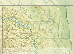
North Dakota is a U.S. state in the midwestern and northern regions of the United States. It is the nineteenth largest in area, the fourth smallest by population, and the fourth most sparsely populated of the 50 states. North Dakota was admitted to the Union on November 2, 1889, along with its neighboring state, South Dakota. Its capital is Bismarck, and its largest city is Fargo.
Fremont is a city in Alameda County, California, United States. It was incorporated on January 23, 1956, from the annexation of Centerville, Niles, Irvington, Mission San José, and Warm Springs. The city is named after John C. Frémont, an American explorer and former US Senator and Military Governor of California.

John Charles Frémont or Fremont was an American explorer, military officer, and politician. He was a US Senator from California, and in 1856 was the first Republican nominee for President of the United States.

Griggs County is a county in the U.S. state of North Dakota. As of the 2010 United States Census, the population was 2,420. Its county seat is Cooperstown.

Winona County is a county in the U.S. state of Minnesota. As of the 2010 census, its population was 51,461. Its county seat is Winona.

Devils Lake is a city in Ramsey County, North Dakota, United States. It is the county seat of Ramsey County. The population was 7,141 at the 2010 census. It is named after the nearby body of water, Devils Lake. The first house in Devils Lake was built in 1882. It was surveyed in 1883 and named Creelsburg and later Creel City, after the surveyor, Heber M. Creel. In 1884 it was renamed Devils Lake.

Lake Union is a freshwater lake entirely within the Seattle, Washington city limits and a major portion of the Lake Washington Ship Canal. Its easternmost point is the Ship Canal Bridge, which carries Interstate 5 over the eastern arm of the lake and separates Lake Union from Portage Bay. Lake Union is the namesake of the neighborhoods located on its east and west shores: Eastlake and Westlake, respectively. The northern shore of the lake is home to Gas Works Park. Notable features of the southern portion of the lake—collectively known as the South Lake Union district—include Lake Union Park, Museum of History & Industry (MOHAI), and the Center for Wooden Boats.
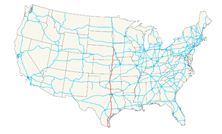
U.S. Route 10 or U.S. Highway 10 (US 10) is an east–west United States highway located in the Midwest and Great Lakes regions of the United States. Unlike most U.S. routes with "0" as the last digit of its route number, US 10 is not a cross-country highway. US 10 was one of the original long-haul highways, running from Detroit, Michigan, to Seattle, Washington, but then losing much of its length when new Interstate Highways were built on top of its right-of-way. In 2010, its length was 565 miles (909 km).
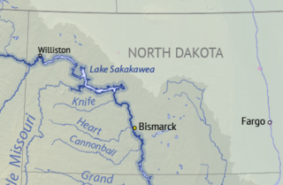
Lake Sakakawea is a large reservoir in the north central United States, impounded by Garrison Dam, a U.S. Army Corps of Engineers dam located in the Missouri River basin in central North Dakota. Named for the Shoshone-Hidatsa woman Sakakawea, it is the largest man-made lake located entirely within the State of North Dakota, the second largest in the United States by area after Lake Oahe, and the third largest in the United States by volume, after Lake Mead and Lake Powell.
U.S. Route 77 is a major north–south United States Numbered Highway which extends for 1,305 miles (2,100 km) in the central United States. As of 2005, Its southern terminus is in Brownsville, Texas, at Veteran's International Bridge on the Mexican border, where it connects with both Mexican Federal Highway 101 and Mexican Federal Highway 180, and the highway's northern terminus is in Sioux City, Iowa, at an interchange with Interstate 29 (I-29).

Westlake is a neighborhood in the city of Seattle, in the U.S. state of Washington, named after its location on the western shore of Lake Union. It is a relatively narrow neighborhood, there being only a few blocks between the shoreline and its western limit at Aurora Avenue N., beyond which is Queen Anne. To the south beyond Aloha Street is South Lake Union, and to the north across the Fremont Cut is Fremont. Its main thoroughfares are Dexter and Westlake Avenues N..
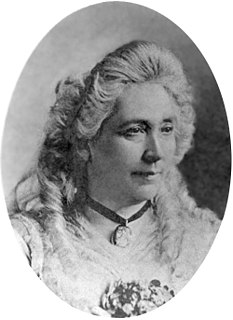
Jessie Ann Benton Frémont was an American writer and political activist.
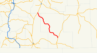
Oregon Route 31 is a state highway in the U.S. state of Oregon that runs between the Central Oregon cities of La Pine and Lakeview. OR 31 traverses most of the Fremont Highway No. 19 of the Oregon state highway system, named after John C. Frémont. The entire length of OR 31 is part of the Outback Scenic Byway, though the byway extends further south beyond the end of OR 31, to the California border.
The Fremont–Winema National Forest is a United States National Forest formed from the 2002 merger of the Fremont and Winema National Forests. They cover territory in southern Oregon from the crest of the Cascade Range on the west past the city of Lakeview to the east. The northern end of the forests is bounded by U.S. Route 97 on the west and Oregon Route 31 on the east. To the south, the state border with California forms the boundary of the forests. Klamath Falls is the only city of significant size in the vicinity. The forests are managed by the United States Forest Service, and the national forest headquarters are located in Lakeview.

Fremont Township is a township in Lake County, Illinois, USA. As of the 2010 census, its population was 32,337.
Lake Poinsett is one of the largest lakes in the state of South Dakota.

Lower Fremont Glacier is east of the Continental Divide in the northern Wind River Range in the U.S. state of Wyoming. The glacier is in the Fitzpatrick Wilderness of Shoshone National Forest, and is among the largest grouping of glaciers in the American Rocky Mountains. Lower Fremont Glacier flows to the southeast and the rapid retreat of this glacier has left behind lateral moraines and a proglacial lake. Lower Fremont Glacier is separated from the Bull Lake Glacier by a moraine and from the Upper Fremont Glacier by cliffs.

Lake Sakakawea State Park is a public recreation area occupying 1,293 acres (523 ha) on the southern shore of Lake Sakakawea in Mercer County, North Dakota. The state park is located adjacent to the Garrison Dam, one mile (1.6 km) north of the community of Pick City.

Lake Kampeska is a 5,250-acre (21 km2) inland glacial lake in the U.S. state of South Dakota. It is located west-northwest of Watertown, South Dakota and lies entirely within Codington County and the Coteau des Prairies. The lake is naturally shaped and the most urban developed lake in South Dakota with approximately 13.5 miles (20 km) of residential shoreline. Lake Kampeska is connected to the Big Sioux River through a single inlet-outlet channel located on the northeast side. It is the third largest natural lake within the borders of South Dakota.