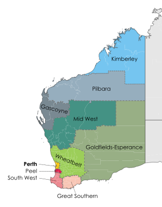
The Goldfields–Esperance region is one of the nine regions of Western Australia. It is located in the south-eastern corner of Western Australia, and comprises the local government areas of Coolgardie, Dundas, Esperance, Kalgoorlie–Boulder, Laverton, Leonora, Menzies, Ngaanyatjarraku, Ravensthorpe and Wiluna.

Norseman is a town located in the Goldfields-Esperance region of Western Australia along the Coolgardie-Esperance Highway, 726 kilometres (451 mi) east of Perth and 278 metres (912 ft) above sea level. It is also the starting point of the Eyre Highway, and the last major town in Western Australia before the South Australian border 720 kilometres (447 mi) to the east. At the 2021 census, Norseman had a population of 562, of which 17% were Australian Aboriginal.

The Wheatbelt is one of nine regions of Western Australia defined as administrative areas for the state's regional development, and a vernacular term for the area converted to agriculture during colonisation. It partially surrounds the Perth metropolitan area, extending north from Perth to the Mid West region, and east to the Goldfields–Esperance region. It is bordered to the south by the South West and Great Southern regions, and to the west by the Indian Ocean, the Perth metropolitan area, and the Peel region. Altogether, it has an area of 154,862 square kilometres (59,793 sq mi).

Coolgardie–Esperance Highway is a 370-kilometre (230 mi) Western Australian highway between Coolgardie and Esperance. It runs in a north–south direction linking the state's Eastern Goldfields to the coast.

The West Coast Range is a mountain range located in the West Coast region of Tasmania, Australia.

The Yilgarn Craton is a large craton that constitutes a major part of the Western Australian land mass. It is bounded by a mixture of sedimentary basins and Proterozoic fold and thrust belts. Zircon grains in the Jack Hills, Narryer Terrane have been dated at ~4.27 Ga, with one detrital zircon dated as old as 4.4 Ga.
The Emily Ann and Maggie Hays nickel deposits are situated 117 km west of the town of Norseman, Western Australia, within the Lake Johnston Greenstone Belt.
The Eastern Goldfields is part of the Western Australian Goldfields in the Goldfields-Esperance region of Western Australia, covering the present and former gold-mining area east of Perth.
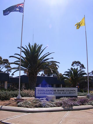
The Shire of Coolgardie is a local government area in the Goldfields–Esperance region of Western Australia, lying roughly west and south of the city of Kalgoorlie. The Shire covers an area of 30,400 square kilometres (11,738 sq mi), and its seat of government is the town of Coolgardie, although the twin towns of Kambalda East and Kambalda West contain two-thirds of the Shire's population.

The Shire of Dundas is a local government area in the Goldfields-Esperance region of Western Australia. The shire covers an area of 93,179 square kilometres (35,977 sq mi) and its seat of government is the town of Norseman. Its territory lies between Norseman and the border with South Australia, and is between 700 and 1,500 kilometres east of the state capital, Perth.

Mallee, also known as Roe Botanical District, is a biogeographic region in southern Western Australia. Located between the Esperance Plains, Avon Wheatbelt and Coolgardie bioregions, it has a low, gently undulating topography, a semi-arid mediterranean climate, and extensive Eucalyptus mallee vegetation. It has an area of 73,975.59 square kilometres (28,562.13 sq mi). About half of the region has been cleared for intensive agriculture. Recognised as a region under the Interim Biogeographic Regionalisation for Australia (IBRA), it was first defined by John Stanley Beard in 1980.
Mining in Western Australia is administered in terms of the administrative divisions of the:-
The Goldfields region of Western Australia has an extensive array of active and historical mining operations and towns.

Widgiemooltha is an abandoned town in Western Australia 631 kilometres (392 mi) east of Perth, Western Australia between Kambalda and Norseman in the Goldfields-Esperance region of Western Australia. It is found on the southern shoreline of Lake Lefroy.
This is a list of newspapers published in, or for, the Goldfields–Esperance region of Western Australia.

Acacia uncinella is a shrub of the genus Acacia and the subgenus Plurinerves that is endemic to an area of south western Australia.
The Kalamaia are an Aboriginal Australian people of the Wheatbelt and Goldfields-Esperance regions of Western Australia.
The Kalaako (Kalarko) were an Aboriginal Australian people of the Goldfields-Esperance region of Western Australia.
Main Roads Western Australia controls the major roads in the state's Goldfields–Esperance region. While the region is the state's largest, the major roads are restricted to the region's western and southern edges. From the major population centres of Kalgoorlie and Coolgardie, Great Eastern Highway heads west towards Perth via the Wheatbelt ; Coolgardie–Esperance Highway leads south to the port of Esperance via Norseman; and Goldfields Highway proceeds north to Wiluna and then on to the Mid West Region. From Norseman, Eyre Highway takes interstate traffic east across the Nullarbor Plain and into South Australia.
Goldfields Woodlands National Park is a national park in the Goldfields-Esperance region of Western Australia, 474 km (295 mi) east of Perth and 120 km (75 mi) west of Kalgoorlie, in the Shire of Coolgardie. The park borders the Boorabbin National Park in the west and is situated along the Great Eastern Highway. It is located in the Coolgardie bioregion.


