
Prairies are ecosystems considered part of the temperate grasslands, savannas, and shrublands biome by ecologists, based on similar temperate climates, moderate rainfall, and a composition of grasses, herbs, and shrubs, rather than trees, as the dominant vegetation type. Temperate grassland regions include the pampas of Argentina, Brazil and Uruguay, and the steppe of Ukraine, Russia and Kazakhstan. Lands typically referred to as "prairie" tend to be in North America. The term encompasses the area referred to as the Interior Lowlands of Canada, the United States, and Mexico, which includes all of the Great Plains as well as the wetter, hillier land to the east.

Voyageurs National Park is an American national park in northern Minnesota near the town of International Falls established in 1975. The park's name commemorates the voyageurs—French-Canadian fur traders who were the first European settlers to frequently travel through the area. The park is notable for its outstanding water resources and is popular with canoeists, kayakers, other boaters, and fishermen. The Kabetogama Peninsula, which lies entirely within the park and makes up most of its land area, is accessible only by boat. To the east of the park lies the Boundary Waters Canoe Area Wilderness.

The Driftless Area is a region in southwestern Wisconsin, southeastern Minnesota, northeastern Iowa, and the extreme northwestern corner of Illinois, of the American Midwest. The region escaped the flattening effects of glaciation during the last ice age and is consequently characterized by steep, forested ridges, deeply carved river valleys, and karst geology characterized by spring-fed waterfalls and cold-water trout streams. Ecologically, the Driftless Area's flora and fauna are more closely related to those of the Great Lakes region and New England than those of the broader Midwest and central Plains regions. Colloquially, the term includes the incised Paleozoic Plateau of southeastern Minnesota and northeastern Iowa. The region includes elevations ranging from 603 to 1,719 feet at Blue Mound State Park and covers 24,000 square miles (62,200 km2). The rugged terrain is due both to the lack of glacial deposits, or drift, and to the incision of the upper Mississippi River and its tributaries into bedrock.

Savanna Portage State Park is a state park of Minnesota, USA, established in 1961 to preserve the historic Savanna Portage, a difficult 6-mile (9.7 km) trail connecting the watersheds of the Mississippi River and Lake Superior. The portage trail crosses a drainage divide separating the West Savanna River, which drains to the Mississippi River and the Gulf of Mexico, from the East Savanna River, which flows in an opposite direction to the Saint Louis River, Lake Superior and the Great Lakes, and the Saint Lawrence River to the Atlantic Ocean.

Big Stone Lake is a long, narrow freshwater lake and reservoir forming the border between western Minnesota and northeastern South Dakota in the United States.

Blue Mounds State Park is a state park of Minnesota, USA, in Rock County near the town of Luverne. It protects an American bison herd which grazes on one of the state's largest prairie remnants.

The Minnesota Department of Natural Resources is the agency of the U.S. state of Minnesota charged with conserving and managing the state's natural resources. The agency maintains areas such as state parks, state forests, recreational trails, and recreation areas as well as managing minerals, wildlife, and forestry throughout the state. The agency is divided into six divisions - Ecological & Water Resources, Enforcement, Fish & Wildlife, Forestry, Lands & Minerals, and Parks & Trails.

The geology of Minnesota comprises the rock, minerals, and soils of the U.S. state of Minnesota, including their formation, development, distribution, and condition.

The Traverse Gap is an ancient river channel occupied by Lake Traverse, Big Stone Lake and the valley connecting them at Browns Valley, Minnesota. It is located on the border of the U.S. states of Minnesota and South Dakota. Traverse Gap has an unusual distinction for a valley: it is crossed by a continental divide, and in some floods water has flowed across that divide from one drainage basin to the other. Before the Anglo-American Convention of 1818 it marked the border between British territory in the north and U.S. – or earlier, French – territory in the south.

Britt is an unincorporated area in Saint Louis County, Minnesota, United States.

The 18,208-acre (73.69 km2) Rice Lake National Wildlife Refuge was established in 1935 and is located in the scenic forest and bog area of northern Minnesota. Visitors can enjoy a range of habitats, including lake, river, bog and hardwood forest.
The Finland State Forest is a state forest located near the unincorporated community of Finland in Lake and Cook counties, Minnesota. Of the over 30,000 acres (12,000 ha), the Minnesota Department of Natural Resources manages a third of the land. The federal United States Forest Service manages roughly a quarter of the total forest acreage, as its boundary overlaps in part with that of Superior National Forest. The remainder is split between Cook and Lake County agencies, and private landowners.
The Bowstring State Forest is a state forest located in Itasca and Cass Counties in Minnesota. It is located entirely within the boundaries of the federally managed Chippewa National Forest, and is managed by the Minnesota Department of Natural Resources.
The Kabetogama State Forest is a state forest located in Koochiching and Saint Louis counties, Minnesota, United States. The forest borders the Superior National Forest and the Boundary Waters Canoe Area Wilderness to the east, the Sturgeon River State Forest to the south, the Nett Lake Indian Reservation to the west, and Voyageurs National Park to the north. The forest is managed by the Minnesota Department of Natural Resources.
The Land O'Lakes State Forest is a state forest located primarily in Cass, Minnesota, with portions extending into adjacent Aitkin and Crow Wing counties. The forest has small shared borders with the Chippewa National Forest to the north, and the Hill River State Forest to east. Over half of the forest's land is managed by the Minnesota Department of Natural Resources; the remaining land is managed by Cass County or is privately held.
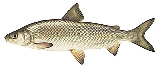
The lake whitefish is a species of freshwater whitefish from North America. Lake whitefish are found throughout much of Canada and parts of the northern United States, including all of the Great Lakes. The lake whitefish is sometimes referred to as a "humpback" fish due to the small size of the head in relation to the length of the body. It is a valuable commercial fish, and also occasionally taken by sport fishermen. Smoked, refrigerated, vacuum-packed lake whitefish fillets are available in North American grocery stores. Other vernacular names used for this fish include Otsego bass, Sault whitefish, gizzard fish, common whitefish, eastern whitefish, Great Lakes whitefish, humpback whitefish, inland whitefish and whitefish.
A slot limit is a tool used by fisheries managers to regulate the size of fish that can legally be harvested from particular bodies of water. Usually set by state fish and game departments, the protected slot limit prohibits the harvest of fish where the lengths, measured from the snout to the end of the tail, fall within the protected interval. For example, on a body of water where there is a protected slot limit on largemouth bass between 12 and 16 inches, largemouth between those lengths may not be harvested. In this example largemouth bass shorter than 12 inches (30 cm) and longer than 16 inches (41 cm) may be removed from the water and kept for personal use in accordance with local fishing regulations.

