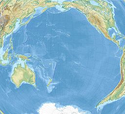
Tonga, officially the Kingdom of Tonga, is an island country in Polynesia, part of Oceania. The country has 171 islands – of which 45 are inhabited. Its total surface area is about 750 km2 (290 sq mi), scattered over 700,000 km2 (270,000 sq mi) in the southern Pacific Ocean. As of 2021, according to Johnson's Tribune, Tonga has a population of 104,494, 70% of whom reside on the main island, Tongatapu. The country stretches approximately 800 km north-south. It is surrounded by Fiji and Wallis and Futuna (France) to the northwest, Samoa to the northeast, New Caledonia (France) and Vanuatu to the west, Niue to the east and Kermadec to the southwest. Tonga is about 1,800 km from New Zealand's North Island.
D'Urville Island, Māori name Rangitoto ki te Tonga, is the largest island in the Marlborough Sounds, on the northern coast of the South Island of New Zealand. It was named after the French explorer Jules Dumont d'Urville. With an area of approximately 150 square kilometres (58 sq mi), it is the eighth-largest island of New Zealand, and has around 52 permanent residents. The local authority is the Marlborough District Council.

The Tonga Trench is an oceanic trench located in the southwestern Pacific Ocean. It is the deepest trench in the Southern hemisphere and the second deepest on Earth after the Mariana Trench. The fastest plate-tectonic velocity on Earth is occurring at this location, as the Pacific plate is being subducted westward in the trench.

The Samoan Islands are an archipelago covering 3,030 km2 (1,170 sq mi) in the central South Pacific, forming part of Polynesia and of the wider region of Oceania. Administratively, the archipelago comprises all of the Independent State of Samoa and most of American Samoa. The land masses of the two Samoan jurisdictions are separated by 64 km of ocean at their closest points.

Tongatapu is the main island of Tonga and the site of its capital, Nukuʻalofa. It is located in Tonga's southern island group, to which it gives its name, and is the country's most populous island, with 74,611 residents (2016), 70.5% of the national population, on 260 square kilometres. Tongatapu is Tonga's centre of government and the seat of its monarchy.

Tutuila is the largest and most populous island of American Samoa and is part of the archipelago of the Samoan Islands. It is the third largest island in the Samoan Islands chain of the Central Pacific. It is located roughly 4,000 kilometers (2,500 mi) northeast of Brisbane, Australia and lies over 1,200 kilometers (750 mi) to the northeast of Fiji. It contains a large, natural harbor, Pago Pago Harbor, where Pago Pago, the capital of American Samoa, is situated. Pago Pago International Airport is also located on Tutuila. The island's land expanse is about 68% of the total land area of American Samoa. With 56,000 inhabitants, it is also home to 95% of the population of American Samoa. The island has six terrestrial and three marine ecosystems.

Wallis is a Polynesian atoll/island in the Pacific Ocean belonging to the French overseas collectivity of Wallis and Futuna. It lies north of Tonga, northeast of Fiji, east-northeast of the Hoorn Islands, east of Fiji's Rotuma, southeast of Tuvalu, southwest of Tokelau and west of Samoa. Its area is almost 100 km2 (39 sq mi) with 8,333 people. Its capital is Mata Utu. Roman Catholicism is the predominant religion. Its highest point is Mount Lulu Fakahega. Wallis is of volcanic origin with fertile soil and some remaining lakes. Rainfall is plentiful.

Matthews Beach is a neighborhood in Seattle, Washington; it and Meadowbrook are the southern neighborhoods of the annexed township of Lake City (1954). Matthews Beach lies about 2 miles (3.2 km) northeast of the University of Washington, about 8 miles (13 km) northeast of Downtown.

Niuatoputapu is a volcanic island in the island nation of Tonga, Pacific Ocean. Its highest point is 157 metres (515 ft), and its area is 16 square kilometres (6.2 sq mi). Its name means sacred island. Older names for the island are Traitors Island or Keppel Island.

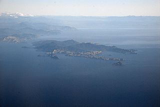
Mata Utu is the capital city of Wallis and Futuna, an overseas collectivity of France. It is located on the island of Uvéa (ʻUvea), in the district of Hahake, of which it is also the capital. It is one of two ports in Wallis and Futuna, the other being at Leava on Futuna. Hihifo Airport, the main airport serving the island and city, is 5.6 kilometres (3.5 mi) to the northwest. Its population was 1,029 in 2018, up from 815 in 1998.

Tofua is a volcanic island in Tonga. Located in the Haʻapai island group, it is a steep-sided composite cone with a summit caldera. It is part of the highly active Kermadec-Tonga subduction zone and its associated volcanic arc, which extends from New Zealand north-northeast to Fiji, and is formed by the subduction of the Pacific Plate under the Indo-Australian Plate. It lies about 100 km (62 mi) above a very active seismic zone. It is connected to the nearby island of Kao by a submarine ridge.

Aunuʻu is a small volcanic island off the southeastern shore of Tutuila in Saʻole County, American Samoa. It has a land area of 374.83 acres, and a 2010 census population of 436 persons. Politically, it is a part of the Eastern District, one of the two primary political divisions of American Samoa.

Lake Lalolalo is a volcanic crater lake surrounded by jungle to the southwest of the island of Wallis (Uvea) in the Pacific Ocean. The largest lake on the island, it lies off Route 1 between the coastal village of Mala'etoli and Ahoa. A small lake, Lake Lano, lies just to the northwest.

The Kermadec–Tonga subduction zone is a convergent plate boundary that stretches from the North Island of New Zealand northward. The formation of the Kermadec and Tonga plates started about 4–5 million years ago. Today, the eastern boundary of the Tonga plate is one of the fastest subduction zones, with a rate up to 24 cm/year (9.4 in/year). The trench formed between the Kermadec–Tonga and Pacific plates is also home to the second deepest trench in the world, at about 10,800 m, as well as the longest chain of submerged volcanoes.
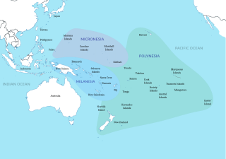
Polynesia is a subregion of Oceania, made up of more than 1,000 islands scattered over the central and southern Pacific Ocean. The indigenous people who inhabit the islands of Polynesia are called Polynesians. They have many things in common, including linguistic relations, cultural practices, and traditional beliefs. In centuries past, they had a strong shared tradition of sailing and using stars to navigate at night.
ʻUvea is one of the three official chiefdoms of the French territory of Wallis and Futuna in Oceania in the South Pacific Ocean.
Fineveke is a village in Wallis and Futuna. It is located in Mua District on the southwest coast of Wallis Island, just northwest of Halalo. Lake Lanutavake lies just to the northeast.
Ottoville is a subdivision or district within the village of Tafuna, American Samoa.
Amalau is a valley and a bay within the National Park of American Samoa. Amalau Valley is located between Vatia and Afono, and it is an isolated valley with various wildlife such as large numbers of native bird species and flying fox megabats. Amalau Valley is reached on the road leading to Vatia. There are only a few homes at Amalau.