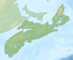
Nova Scotia is one of the thirteen provinces and territories of Canada. It is one of the three Maritime provinces and one of the four Atlantic provinces. Nova Scotia is Latin for "New Scotland."

Halifax is the capital and largest municipality of the Canadian province of Nova Scotia, and the largest municipality in Atlantic Canada. Halifax is one of Canada's fastest growing municipalities, and as of 2022, it is estimated that the CMA population of Halifax was 480,582, with 348,634 people in its urban area. The regional municipality consists of four former municipalities that were amalgamated in 1996: Halifax, Dartmouth, Bedford, and Halifax County.
Spryfield is community within the urban area of Halifax, Nova Scotia, Canada.
Highway 102 is a north–south highway in the Canadian province of Nova Scotia that runs from Halifax to Onslow, immediately north of the town of Truro. It is the busiest highway in Atlantic Canada.
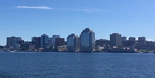
Downtown Halifax is the primary central business district of the Municipality of Halifax. Located on the central-eastern portion of the Halifax Peninsula, on Halifax Harbour. Along with Downtown Dartmouth, and other de facto central business districts within the Municipality, Downtown Halifax serves as the business, entertainment, and tourism hub of the region.

The Eastern Shore is a region of the Canadian province of Nova Scotia. It is the Atlantic coast running northeast from Halifax Harbour to the eastern end of the peninsula at the Strait of Canso.
The Halifax Regional Municipality (HRM) in Nova Scotia, Canada has a widely varied geography.

The Musquodoboit River is a Canadian river located in central Nova Scotia in the northeastern part of Halifax Regional Municipality. The river is approximately 97 kilometres (60 mi) in length with roughly 88 kilometres (55 mi) being traversable by paddle. It has a watershed area of 1,409 square kilometres (544 sq mi)

Timberlea—Prospect is a provincial electoral district in Nova Scotia, Canada, that elects one member of the Nova Scotia House of Assembly. Its Member of the Legislative Assembly (MLA) since 2013 has been Iain Rankin of the Nova Scotia Liberal Party.
Route 328 is a short collector road in the Canadian province of Nova Scotia.
Westphal is an unincorporated community located in Dartmouth, Nova Scotia and outside of Dartmouth, Nova Scotia. Some of Westphal is considered part of Dartmouth, Nova Scotia and some of it is considered separate from Dartmouth, Nova Scotia. The area is bound by Port Wallace in the north, Waverley Road in the west, Lake Major Road in the east, and Main Street in the south. The area also includes the watershed and water filtration plant for the Halifax Regional Water Commission that supplies drinking water for the residents of Dartmouth and surrounding communities east of Halifax Harbour.
Porters Lake is a rural community in the Eastern Shore region of the Halifax, Nova Scotia, Canada, between Trunk 7 and Route 207, 27.8 km from Halifax. The residents mainly commute to jobs in Dartmouth, Burnside Industrial Park or in Downtown Halifax. The community is built around the lake from which it takes its name.
Halifax, Nova Scotia, with the largest urban population in Atlantic Canada, is a major sporting centre.

Nova Scotia is a province located in Eastern Canada fronting the Atlantic Ocean. One of the Maritime Provinces, Nova Scotia's geography is complex, despite its relatively small size in comparison to other Canadian provinces.
Lake Charles is a small lake in Nova Scotia’s Halifax Regional Municipality between the communities of Dartmouth and Waverley. It is situated between Port Wallace in the south and Nova Scotia Highway 107 in the North, Nova Scotia Highway 118 in the west and Nova Scotia Route 318 to the east. It is the summit of the Shubenacadie Canal, where the level of the surface is 31 m above sea level. Located in the Shubenacadie watershed, it ultimately feeds into the Bay of Fundy. However, it also feeds into Halifax Harbour through the canal locks at Shubie Park.
Dunbrack Street is a 9.2 km (5.7 mi) arterial road in Mainland Halifax, Nova Scotia. It runs from Route 306 in Spryfield to Kearney Lake Road in Rockingham. Prior to 2019, Dunbrack Street ran from Kearney Lake Road in Rockingham to Main Avenue in Fairview. The remaining section was named Northwest Arm Drive until 2019. The former Northwest Arm section is assigned Trunk 32 by the provincial transportation department as an unsigned highway.
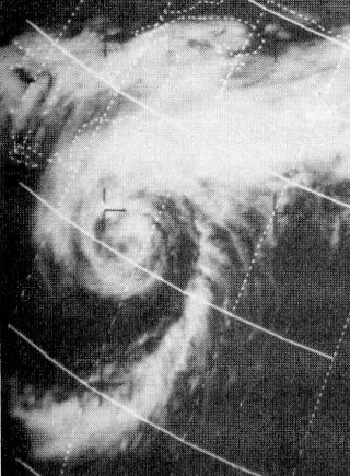
Hurricane Beth was a short-lived tropical cyclone which traveled from Florida to Nova Scotia in the middle of August 1971. The second named storm of the 1971 Atlantic hurricane season, Beth's genesis was impeded by a cold environment surrounding the storm. However, as it continued on its northeastward course, it achieved fully tropical characteristics and peaked as a modest Category 1 hurricane on the Saffir–Simpson Hurricane Scale. The cyclone struck Nova Scotia on August 16 before dissipating shortly after. Beth produced substantial precipitation, and the resultant flooding inflicted severe damage to infrastructure and crops.

Clayton Park West is a provincial electoral district in Nova Scotia, Canada, that elects one member of the Nova Scotia House of Assembly.
Upper Hammonds Plains is a Canadian suburban community located in Nova Scotia's Halifax Regional Municipality.
The following outline is provided as an overview of and topical guide to Nova Scotia: