
Lake Superior, the largest of the Great Lakes of North America, is also the world's largest freshwater lake by surface area, and the third largest freshwater lake by volume. It is shared by the Canadian province of Ontario to the north, the U.S. state of Minnesota to the west, and Wisconsin and the Upper Peninsula of Michigan to the south. The farthest north and west of the Great Lakes chain, Superior has the highest elevation of all five great lakes and drains into the St. Mary's River.

Marquette is a city in the U.S. state of Michigan and the county seat of Marquette County. The population was 21,355 at the 2010 census, making it the largest city of the state's Upper Peninsula. Marquette is a major port on Lake Superior, known primarily for shipping iron ore, and is the home of Northern Michigan University. In 2012, Marquette was listed among the 10 best places to retire in the United States by CBS MoneyWatch.

The Upper Peninsulaof Michigan – also known as Upper Michigan or colloquially the U.P. – is the northern and more elevated of the two major landmasses that make up the U.S. state of Michigan, the other being the Lower Peninsula. It is bounded primarily by Lake Superior to the north, separated from the Canadian province of Ontario at the east end by the St. Marys River, and flanked by Lake Huron and Lake Michigan along much of its south. The Straits of Mackinac separate it from the Lower Peninsula of Michigan to the south. Although the peninsula extends as a geographic feature into the state of Wisconsin, the state boundary follows the Montreal and Menominee rivers and a line connecting them.

Powell Township is a civil township of Marquette County in the U.S. state of Michigan. The population was 724 at the 2000 census.

Bemidji Township is a township in Beltrami County, Minnesota, United States. The population was 3,134 as of the 2010 census.

Father Jacques Marquette S.J., sometimes known as Père Marquette or James Marquette, was a French-American Jesuit missionary who founded Michigan's first European settlement, Sault Ste. Marie, and later founded St. Ignace, Michigan. In 1673, Marquette, with Louis Jolliet, an explorer born near Quebec City, was the first European to explore and map the northern portion of the Mississippi River Valley.
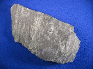
Taconite is a variety of iron formation, an iron-bearing sedimentary rock, in which the iron minerals are interlayered with quartz, chert, or carbonate. The name "taconyte" was coined by Horace Vaughn Winchell (1865–1923) – son of Newton Horace Winchell, the Minnesota State Geologist – during their pioneering investigations of the Precambrian Biwabik Iron Formation of northeastern Minnesota. He noted the rock had a superficial resemblance to iron-bearing rocks from the Taconic Mountains of New York state.

The term Iron Range refers collectively or individually to a number of elongated iron-ore mining districts around Lake Superior in the United States and Canada. Despite the word "range", the iron ranges are not mountain chains, but outcrops of Precambrian sedimentary formations containing high percentages of iron. These cherty iron ore deposits are Precambrian in age for the Vermilion Range, while middle Precambrian in age for the Mesabi and Cuyuna ranges, all in Minnesota. The Gogebic Range in Wisconsin and the Marquette Iron Range and Menominee Range in Michigan have similar characteristics and are of similar age. Natural ores and concentrates were produced from 1848 until the mid 1950s, when taconites and jaspers were concentrated and pelletized, and started to become the major source of iron production.
Edward Breitung was a politician from the U.S. state of Michigan.
The Cuyuna Range is an iron range to the southwest of the Mesabi Range, largely within Crow Wing County, Minnesota. It lies along a 68-mile-long (109 km) line between Brainerd, Minnesota, and Aitkin, Minnesota. The width ranges from 1 to 10 miles.

The Federal Reserve Bank of Minneapolis, located in Minneapolis, Minnesota, in the United States, covers the 9th District of the Federal Reserve, which is made up of Minnesota, Montana, North and South Dakota, northwestern Wisconsin, and the Upper Peninsula of Michigan. Although its geographical territory is the third largest of the 12 Federal Reserve banks, it serves the smallest population base of the system. It has one branch, which is in Helena, Montana.
Bachelor Lake is a lake in Brown County, Minnesota in the northeastern part of Stark township. Covering 79.80 acres, it is an officially protected water of the State of Minnesota. The lake is within the Cottonwood River Major Watershed. The lake’s elevation is 1,004 feet (306 m), and it is zoned as a shoreland area which is regulated as a shoreland management water.
The Whitefish River is an 11.9-mile-long (19.2 km) river on the Upper Peninsula of the U.S. state of Michigan. The mouth of the river is in Delta County at 45°54′34″N86°58′01″W on the Little Bay De Noc of Lake Michigan. The main branch of the river is formed by the confluence of the east and west branches at 46°03′25″N86°52′17″W.

The Pere Marquette River is a river in Michigan in the United States. The main stream of this river is 63.9 miles (102.8 km) long, running from Lake County south of Baldwin into the Pere Marquette Lake, and from there into Lake Michigan.

Michigan consists of two peninsulas surrounded primarily by four of the Great Lakes and a variety of nearby islands. The Upper Peninsula is bounded on the southwest by Wisconsin, and the Lower Peninsula is bounded on the south by Indiana and Ohio. Both land masses are also separated from the Canadian province of Ontario by waterways of the Great Lakes, and from each other by the Straits of Mackinac. Because its land is largely surrounded by the Great Lakes, which flow into the Saint Lawrence River, Michigan is the only U.S. state whose streams and rivers are almost entirely within the Great Lakes-St. Lawrence watershed.
The Marquette Iron Range is a deposit of iron ore located in Marquette County, Michigan in the United States. The towns of Ishpeming and Negaunee developed as a result of mining this deposit. A smaller counterpart of Minnesota's Mesabi Range, this is one of two iron ranges in the Lake Superior basin that are in active production as of 2018. The iron ore of the Marquette Range has been mined continuously from 1847 until the present day. Marquette Iron Range is the deposit's popular and commercial name; it is also known to geologists as the Negaunee Iron Formation.
Carp River is the name of several rivers in the U.S. state of Michigan.
Carp River is a 21.9-mile-long (35.2 km) river in Marquette County in the U.S. state of Michigan. The Carp River is formed by the outflow of Deer Lake in Ishpeming Township north of Ishpeming at 46°31′58″N87°40′01″W in the Upper Peninsula.
