
Karst is a topography formed from the dissolution of soluble carbonate rocks such as limestone, dolomite, and gypsum. It is characterized by features like poljes above and drainage systems with sinkholes and caves underground. It has also been documented for more weathering-resistant rocks, such as quartzite, given the right conditions. Subterranean drainage may limit surface water, with few to no rivers or lakes. However, in regions where the dissolved bedrock is covered or confined by one or more superimposed non-soluble rock strata, distinctive karst features may occur only at subsurface levels and can be totally missing above ground.
The Quaternary is the current and most recent of the three periods of the Cenozoic Era in the geologic time scale of the International Commission on Stratigraphy (ICS). It follows the Neogene Period and spans from 2.58 million years ago to the present. The Quaternary Period is divided into two epochs: the Pleistocene and the Holocene although a third epoch, the Anthropocene, has been proposed but is not officially recognised by the ICS.

Travertine is a form of terrestrial limestone deposited around mineral springs, especially hot springs. It often has a fibrous or concentric appearance and exists in white, tan, cream-colored, and even rusty varieties. It is formed by a process of rapid precipitation of calcium carbonate, often at the mouth of a hot spring or in a limestone cave. In the latter, it can form stalactites, stalagmites, and other speleothems. It is frequently used in Italy and elsewhere as a building material. Similar deposits formed from ambient-temperature water are known as tufa.

Lake Garda is the largest lake in Italy. It is a popular holiday location in northern Italy, between Brescia and Milan to the west, and Verona and Venice to the east. The lake cuts into the edge of the Italian Alps, particularly the Alpine sub-ranges of the Garda Mountains and the Brenta Group. Glaciers formed this alpine region at the end of the last ice age. The lake and its shoreline are divided between the provinces of Brescia, Verona (south-east) and Trentino (north).

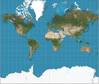
An endorheic basin is a drainage basin that normally retains water and allows no outflow to other external bodies of water, such as rivers or oceans, where drainage converges instead into lakes or swamps, permanent or seasonal, that equilibrate through evaporation. They are also called closed or terminal basins, internal drainage systems, or simply basins. Endorheic regions contrast with exorheic regions, where surface waters eventually drain into the ocean. Endorheic water bodies include some of the largest lakes in the world, such as the Caspian Sea, the world's largest inland body of water.

A midfielder is an outfield position in association football. Midfielders may play an exclusively right back role, breaking up attacks, and are in that case known as defensive midfielders. As central midfielders often go across boundaries, with mobility and passing ability, they are often referred to as deep-lying midfielders, play-makers, box-to-box midfielders, or holding midfielders. There are also attacking midfielders with limited defensive assignments.
In the sport of association football, a defender is an outfield position whose primary role is to stop attacks during the game and prevent the opposition from scoring.

Zone is a comune in the province of Brescia, in Lombardy, northern Italy. It is situated in a mountain valley east of Lake Iseo. The town is known for the nearby "Pyramids of Zone", formations of large rock pillars created by erosion. Its coat of arms shows three of these pillars.
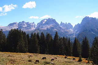
The Brenta Group or Brenta Dolomites is a mountain range, and a subrange of the Rhaetian Alps in the Southern Limestone Alps mountain group. They are located in the Province of Trentino, in northeastern Italy. It is the only dolomitic group west of the Adige River. Therefore, geographically, they have not always been considered a part of the Dolomites mountain ranges. Geologically, however, they definitely are - and therefore sometimes called the "Western Dolomites". As part of the Dolomites, the Brenta Group has been officially recognized as UNESCO World Heritage Site under the World Heritage Convention.
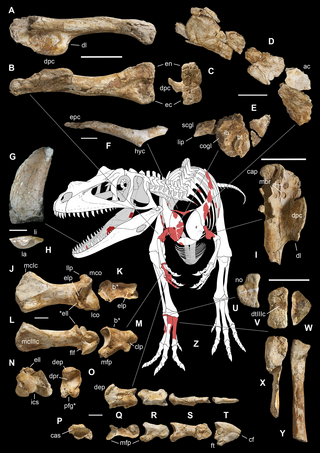
Saltriovenator is a genus of ceratosaurian dinosaur that lived during the Sinemurian stage of the Early Jurassic in what is now Italy. The type and only species is Saltriovenator zanellai; in the past, the species had been known under the informal name "saltriosaur". Although a full skeleton has not yet been discovered, Saltriovenator is thought to have been a large, bipedal carnivore similar to Ceratosaurus.

Attilio Luigi Antonio Bettega was an Italian rally driver.

Cavedago is a comune (municipality) in Trentino in the northern Italian region Trentino-Alto Adige/Südtirol, located about 14 kilometres (9 mi) northwest of Trento. As of 31 December 2004, it had a population of 507 and an area of 10.0 square kilometres (3.9 sq mi).

Molveno is a comune (municipality) in Trentino in the northern Italian region of Trentino-Alto Adige/Südtirol, located about 40 kilometres (25 mi) northwest of Trento. It is famous for its positioning on Lake Molveno as a holiday destination, its nearby ski resorts (Andalo-Paganella) and its connection to the National Park Adamello Brenta.

Spormaggiore is a comune (municipality) in Trentino in the northern Italian region Trentino-Alto Adige/Südtirol, located about 15 kilometres (9 mi) northwest of Trento. As of October 2011, it had a population of 1,259 and an area of 30.2 square kilometres (11.7 sq mi).

Terlago was a comune (municipality) in Trentino in the northern Italian region Trentino-Alto Adige/Südtirol, located about 6 kilometres (4 mi) northwest of Trento. As of 31 December 2004, it had a population of 1,571 and an area of 37.0 square kilometres (14.3 sq mi). It was merged with Padergnone and Vezzano on January 1, 2016, to form a new municipality, Vallelaghi.
Tuenno was a comune (municipality) in Trentino in the northern Italian region Trentino-Alto Adige/Südtirol, located about 30 kilometres (19 mi) north of Trento. As of 31 December 2004, it had a population of 2,291 and an area of 70.7 square kilometres (27.3 sq mi). It was merged with Tassullo and Nanno on January 1, 2016, to form a new municipality, Ville d'Anaunia.

Paganella is a mountain of the Brenta Group in Trentino, northern Italy. It is located in the territories of the comuni of Fai della Paganella, Andalo, Molveno, Zambana and Terlago. Overlooking Trento from north-west, it consists of a short range/plateau with a highest elevation of 2,125 m.

Cima Tosa is a mountain in the Brenta group, a subgroup of the Rhaetian Alps in the Italian Region of Trentino-Alto Adige, with a reported height of 3,136 metres (10,289 ft). it is the second highest peak of the Brenta group in the southern limestone Alps after the Cima Brenta.
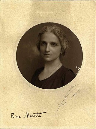
Cesarina Monti, better known as Rina Monti and, sometimes, as Rina Monti Stella, was an Italian scientist. A biologist, physiologist, limnologist and zoologist, in 1907 she became the first woman to obtain a university chair in the Kingdom of Italy.
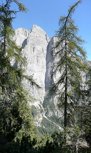
Croz dell'Altissimo is a mountain in the Brenta group, a subgroup of the Rhaetian Alps in the Italian Region of Trentino-Alto Adige, with a height of 2,339 metres (7,674 ft)). The mountain is mostly known for its imposing South-West face that rises with a straight vertical 900 meters from Val dell Seghe, above Molveno, up to the summit ridge. The mountain has actually two distinct summits, a NW and a SE summit, of which the former is slightly higher but the latter bears the cross. The east and north sides of the mountain are quite easily accessible for hikers.


