
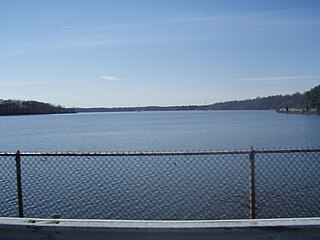
Lake Barcroft is a census-designated place (CDP) in Fairfax County, Virginia, United States. The population was 9,558 at the 2010 census. It is also the name of the privately owned lake—part of the Cameron Run Watershed—around which this population is located. The lake is named for Dr. John W. Barcroft, who owned and operated a mill on Holmes Run during the mid-19th century.

Falmouth is a census-designated place (CDP) in Stafford County, Virginia, United States. Situated on the north bank of the Rappahannock River at the falls, the community is north of and opposite the city of Fredericksburg. Recognized by the U.S. Census Bureau as a census-designated place (CDP), Falmouth's population was 4,274 as of the 2010 census.

The Catawba River is a major river located in the Southeastern United States. It originates in Western North Carolina and flows into South Carolina, where it later becomes known as the Wateree River. The river is approximately 220 miles (350 km) long. It rises in the Appalachian Mountains and drains into the Piedmont, where it has been impounded through a series of reservoirs for flood control and generation of hydroelectricity. The river is named after the Catawba tribe of Native Americans, which lives on its banks. In their language, they call themselves "yeh is-WAH h’reh", meaning "people of the river."
Lake Tappan is a reservoir impounded by the Tappan Dam on the Hackensack River, straddling the border between the U.S. states of New Jersey and New York. Within New Jersey, the lake traverses the border separating the municipalities of River Vale and Old Tappan in Bergen County, while extending northward across the New York state line into the town of Orangetown in Rockand County. The reservoir was formed in 1967, flooding areas that included the former CAPROC Field Civil Air Patrol airstrip.

The Watauga River is a large stream of western North Carolina and East Tennessee. It is 78.5 miles (126.3 km) long with its headwaters in Linville Gap to the South Fork Holston River at Boone Lake.

The Derwent Reservoir is a reservoir on the River Derwent, on the border between County Durham and Northumberland, in England. It is west of Consett. It is 3.5 miles (5.6 km) long) and covers an area of 4 km2 and has a maximum depth of 100 ft (30m) and when full, holds 11,000 million gallons (50,000,000m³).

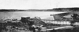
The Kensico Reservoir is a reservoir spanning the towns of Armonk and Valhalla, New York, located 3 miles (5 km) north of White Plains. It was formed by the original earth and gravel Kensico Dam constructed in 1885, which impounded waters from the Bronx and Byram rivers. In 1917, a new masonry dam was completed, replacing the old dam and expanding the water supply by bringing water from the Catskill Mountains over a distance of more than 100 miles.

The John H. Kerr Reservoir is a reservoir along the border of the U.S. states of North Carolina and Virginia. The U.S. Army Corps of Engineers constructed the John H. Kerr Dam across the Roanoke River between 1947 and 1952 to produce hydroelectricity as well as for flood control. Kerr Lake is the largest lake in Virginia, with 850 miles (1,370 km) of shoreline located in Vance, Granville, and Warren counties in North Carolina, as well as Mecklenburg, Charlotte, and Halifax counties in Virginia. At its maximum capacity, it covers approximately 50,000 acres (200 km2) and is one of the largest reservoirs in the Southeastern United States. The name honors its Congressional sponsor, John H. Kerr, a North Carolina Democrat who supported creation of the lake. The lake supports recreational tourism in North Carolina and Virginia as described below.

The Saugatuck Reservoir is a reservoir in Fairfield County, Connecticut, United States, that straddles the border between the towns of Redding, Weston, and Easton. Its completion is marked by the creation of the Samuel P. Senior dam of the Saugatuck River in January 1942, and provides water to several of the nearby towns. The reservoir is surrounded by the Centennial Watershed State Forest and a small section of the Trout Brook Valley State Park Reserve on the southeast end of the reservoir. The Saugatuck Reservoir utilizes an uncontrolled spillway adjacent to the Samuel P. Senior dam that effectively limits the maximum water level. There is also a concrete levee positioned on the southeastern side of the reservoir that prevents water from flooding Trout Brook Valley.

Spruce Run Recreation Area is a 1,290-acre (5.2 km2) New Jersey state recreation area located in Union Township and Clinton Township in Hunterdon County, New Jersey, United States. It encompasses the Spruce Run Reservoir that is used as a backup reservoir to protect the state from prolonged droughts. The reservoir is the third largest in the state, after Round Valley and Wanaque Reservoir. The reservoir is used for recreation purposes, including hunting, fishing, boating and swimming.
The Loch Raven Reservoir is a reservoir that provides drinking water for the City of Baltimore and most of Baltimore County, Maryland. It is fed by the Big Gunpowder Falls river, and has a capacity of 23 billion US gallons (87,000,000 m3) of water.

Lake Chesdin is a lake in south-central Virginia, on the border of Chesterfield County and Dinwiddie County and going upstream into Amelia County. It provides water and power to the region. It is also a popular fishing area and is known to have great opportunities for largemouth bass. It is also known to have populations of crappie, bluegill, walleye, striped bass, channel catfish, gizzard shad and white perch.

Highland Springs is a set of springs which was turned into a resort in the 19th century in Lake County, California. The resort grew to be able to accommodate 200 people, attracted by the curative powers of the mineral waters and the lovely mountain scenery. In the 1920s its popularity waned, the hotel was partly burned, and it passed through various hands before the county claimed eminent domain, bought the property, and flooded it with the Highland Springs Reservoir. The reservoir is surrounded by the Highland Springs Recreation Area, managed by the county.
Piney Run Park is a nature park in Sykesville, located in Carroll County, Maryland. It is Carroll County's oldest developed park and hosts thousands of visitors annually. The park encompasses 550 acres of fields, forest and open spaces, features over 15 miles of hiking trails, a 300-acre lake and many sports and recreational facilities. Prior to being a park, this land was a private farm.
Hinckley Lake is located by Hinckley, New York. Originally dammed up to supply water to the Erie Canal, the lake provides municipal water supply to 130,000 people in the greater Utica, New York area, is a source of hydropower, and supports recreation during all seasons. The lake is located in the towns of Russia in Herkimer County, and Remsen in Oneida County. This body of water is one of many man made lakes in the Upstate NY region. Its sister lake is Delta Lake, also dammed up to supply water to the Erie Canal.
Woods Reservoir is a 3,600 acre reservoir created by the United States Army Corps of Engineers for use as a cooling system for the United States Air Force's Arnold Engineering Development Center. The US Air Force and Arnold Engineering Development Center own and operate Woods Reservoir.
Pikes Creek Reservoir is a reservoir in Luzerne County, Pennsylvania, in the United States. It has a surface area of approximately 400 acres (160 ha) and is situated in Lehman Township, Jackson Township, and Plymouth Township. The lake is situated on Pikes Creek. It has a volume of approximately 3 billion gallons and is used as a water supply reservoir. As of 2013, it is inhabited by fifteen fish species. The reservoir is owned by the Pennsylvania-American Water Company, but shoreline fishing is permitted at designated spots.

Lake McIntosh is a 650-acre (260 ha) reservoir in Peachtree City, Georgia. It holds 1.5 billion gallons of water, and supplies 10.4 million gallons a day to the Crosstown Water Treatment Plant.

