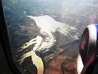
The Potholes Reservoir is part of the Columbia Basin Irrigation Project. It is formed by the O'Sullivan Dam and located in central Washington, in the United States. The reservoir is fed by water from Moses Lake, part of the Crab Creek basin.

Henrys Lake is a small, shallow alpine lake in the western United States, in eastern Idaho. Approximately 8 square miles (21 km2) in area, at 4 miles (6.4 km) in length and 2 miles (3.2 km) in width, its surface elevation is 6,472 ft (1,973 m) above sea level.

Angle Lake is an L-shaped lake in SeaTac, Washington, United States, occupying 102 acres (0.41 km2) between Interstate 5 and State Route 99. The lake most likely was so named on account of its outline. On the western shore is a 10-acre (0.040 km2) park, Angle Lake Park, administered by the City of SeaTac Parks and Recreation department. The remainder of the shoreline is ringed with private homes.

Merrill Creek Reservoir, located in Harmony Township, New Jersey in central Warren County, New Jersey, is a 650-acre (260 ha) artificial lake designed to hold 15 billion gallons of water that is surrounded by 290 acres (120 ha) of protected woodland and fields. These lands are themselves part of 2,000 acres (8.1 km2) of open spaces.

Battle Ground Lake State Park is a 275-acre (111 ha) public recreation area located three miles (4.8 km) northeast of the city of Battle Ground, Washington. The state park is covered by an evergreen forest located around a crater lake of volcanic origin. The park is managed by the Washington State Parks and Recreation Commission.

Foster Reservoir is a reservoir created by Foster Dam on the South Santiam River in the city of Foster, Oregon, United States. The reservoir is approximately 5.6 km (3.5 mi) long and covers approximately 494 ha when full. Primary use of the reservoir is recreation in the summer and flood control in the winter and spring.
Strawberry Reservoir is a large reservoir in the U.S. state of Utah. It is Utah's most popular fishery, receiving over 1.5 million angling hours annually and is part of the Blue Ribbon Fisheries program. Game fish in the reservoir include sterilized rainbow trout, bear lake cutthroat trout, kokanee salmon and crayfish. It is located 23 miles (37 km) southeast of Heber, Utah on U.S. Route 40. The reservoir is situated in Strawberry Valley. This valley is normally part of the Colorado River drainage. The dam was constructed to divert water into Utah Valley.

Nolte State Park is a 117-acre (47 ha) Washington state park located 6 miles (9.7 km) northeast of Enumclaw and just south of Cumberland at the western edge of the Cascade Mountains, with 7,174 feet (2,187 m) of shoreline on Deep Lake near the Green River Gorge. The property was a resort for many years before it was donated to the state by Minnie Nolte in the early 1970s. There are rainbow trout, coastal cutthroat trout, kokanee, crappie, and brown bullhead in the lake. The lake has a public fishing pier, beach area, and a hiking trail around the lake. The boat launch is carry-in only with limited parking. Deep Lake has a surface area of 39 acres (16 ha) and reaches a depth of 76 feet (23 m).

The Crooked River is a tributary, 125 miles (201 km) long, of the Deschutes River in the U.S. state of Oregon. The river begins at the confluence of the South Fork Crooked River and Beaver Creek. Of the two tributaries, the South Fork Crooked River is the larger and is sometimes considered part of the Crooked River proper. A variant name of the South Fork Crooked River is simply "Crooked River". The Deschutes River flows north into the Columbia River.

Lost Creek Lake is a reservoir located on the Rogue River in Jackson County, Oregon, United States. The lake is impounded by William L. Jess Dam which was constructed by the U.S. Army Corps of Engineers in 1977 for flood control and fisheries enhancement. The lake and dam were the first completed elements of the multi-purpose Rogue River Basin Project, consisting of Lost Creek Lake, Applegate Lake and the Elk Creek project. The lake is located approximately 27 miles (43 km) northeast of Medford.

Chandler State Wayside is a state park in south-central Oregon in the United States. It is named in honor of Solomon and Hattie Chandler, who donated the land for the park. The park covers 85 acres (34 ha) of pine forest along a creek. The park provides restrooms and other basic facilities to accommodate the traveling public. Chandler State Wayside is administered by the Oregon Parks and Recreation Department.

Diamond Lake is a natural body of water in the southern part of the U.S. state of Oregon. It lies near the junction of Oregon Route 138 and Oregon Route 230 in the Umpqua National Forest in Douglas County. It is located between Mount Bailey to the west and Mount Thielsen to the east; it is just north of Crater Lake National Park.

The Wood River is a short river in the southern region of the U.S. state of Oregon, and part of the Klamath Basin drainage. It flows 18 miles (29 km) through the Fremont-Winema National Forests, Bureau of Land Management land, and private property in southern Oregon. Its watershed consists of 220 square miles (570 km2) of conifer forest, rural pasture land, and marsh. The river provides habitat for many species of wildlife including an adfluvial (migratory) and resident populations of native Great Basin redband trout.
Rainbow Lake is a 116-acre manmade lake near the town of Pinetop-Lakeside in southern Navajo County, Arizona, United States. The lake was created in 1903 when Mormon settlers dammed Walnut Creek, a tributary of the Little Colorado River, to impound water for irrigation.
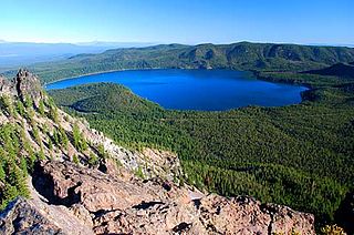
Paulina Lake is one of the twin crater lakes in Newberry Crater, central Oregon, United States. It is located 6,331 feet (1,930 m) above sea level in the Newberry National Volcanic Monument near La Pine. The lake's primary inflow is seepage from East Lake, snow melt, and hot springs, and its outflow is Paulina Creek, a tributary of the Little Deschutes River. It has an area of 1,531 acres (619.6 ha), a volume of 249,850 acre-feet (308,185 dam3), a maximum depth of 250 feet (76.2 m), a shore length of about 6.7 miles (11 km), and a residence time of about 46 years. The lake is classified as mesotrophic, with a transparency of approximately 13.1 feet (3.99 m). It is about 40 feet (12 m) lower and one mile west of its twin, East Lake.

Laguna Niguel Lake, formerly known as Sulphur Creek Reservoir, is an artificial 44-acre (180,000 m2) fishing and recreational lake in Laguna Niguel, California. It is created by the Sulphur Creek Dam, which was completed in 1966. It is located at 33°32′59″N117°42′22″W and is 190 feet (58 m) above sea level. It is fed from two sources, one of which is Sulphur Creek itself and the other, a storm drain. It is accessed from La Paz Road, which runs along its east shore. Surrounding the reservoir is the Laguna Niguel Regional Park. In addition, within the lake on the large island is a protected bird sanctuary.
Eagle Lake trout, Oncorhynchus mykiss aquilarum, is a subspecies of rainbow trout endemic to Eagle Lake, in Lassen County, California. It is a type of trout known for its ability to withstand high alkalinity. Its unique adaptations to the harsh environment of Eagle Lake make the fish a specialist with a very narrow environmental specificity.
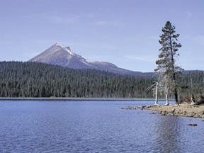
Lake of the Woods is a natural lake near the crest of the Cascade Range in the Fremont–Winema National Forest in southern Oregon in the United States. The lake covers 1,146 acres (4.64 km2). It was named by Oliver C. Applegate in 1870. Today, the Oregon Department of Fish and Wildlife manages the lake's fishery. The small unincorporated community of Lake of the Woods is located on the east shore of the lake. Lake of the Woods is one of southern Oregon's most popular outdoor recreation sites.
There are three Manistique Lakes in the Upper Peninsula of Michigan. The lakes include North Manistique Lake, Big Manistique Lake, and South Manistique Lake. The towns surrounding the lakes are Curtis, Germfask, and Helmer. The lakes are known for vacationing and fishing. They are also in close proximity to other natural sights such as the Great Lakes, rivers, and smaller lakes as well as tourist attractions including the Canada–US border, the Soo Locks, Mackinac Island, parks, and museums.
Myrtle Lake is a freshwater lake located on the northern slope of Big Snow Mountain between Snoqualmie Lake and Chetwoot Lake, in King County, Washington. Self-issued Alpine Lake Wilderness permit required for transit within the Big Snow Mountain area. Because Myrtle Lake is at the heart of the Alpine Lakes Wilderness, the lake is a popular area for hiking, swimming, and fishing rainbow trout and coastal cutthroat trout.
