
Lake Ontario is one of the five Great Lakes of North America. It is surrounded on the north, west, and southwest by the Canadian province of Ontario, and on the south and east by the American state of New York, whose water boundaries meet in the middle of the lake. Ontario, Canada's most populous province, was named for the lake. Many of Ontario's most populous cities, including Toronto, Canada's most populous city, and Hamilton, are on the lake's northern or western shores. In the Huron language, the name Ontarí'io means "Lake of Shining Waters". Its primary inlet is the Niagara River from Lake Erie. The last in the Great Lakes chain, Lake Ontario serves as the outlet to the Atlantic Ocean via the Saint Lawrence River. It is the only Great Lake not to border the state of Michigan.

The Rideau Canal, also known unofficially as the Rideau Waterway, connects Canada's capital city of Ottawa, Ontario, to Lake Ontario and the Saint Lawrence River at Kingston, Ontario. It is 202 kilometres in length. The name Rideau, French for "curtain", is derived from the curtain-like appearance of the Rideau River's twin waterfalls where they join the Ottawa River. The canal system uses sections of two rivers, the Rideau and the Cataraqui, as well as several lakes. The Rideau Canal is operated by Parks Canada.
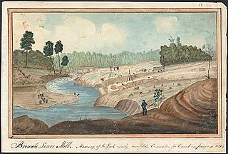
The Cataraqui River forms the lower portion of the Rideau Canal and drains into Lake Ontario at Kingston, Ontario. The name is taken from the original name for Kingston, Ontario; its exact meaning, however, is undetermined. Early maps showed several name variations including the Great Cataraqui River and Grand River Cataraquay. The river was once called Riviere de Frontenac, or Frontenac River.
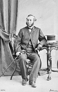
Sir Alexander Campbell was an English-born, Upper Canadian statesman and a father of Canadian Confederation.
King's Highway 33, commonly referred to as Highway 33 or Loyalist Parkway, is a provincially maintained highway in the Canadian province of Ontario. The route begins at Highway 62 in Bloomfield and travels east to the Collins Bay Road junction at Collins Bay in the city of Kingston, a distance of 60.9 kilometres (37.8 mi). The highway continues farther east into Kingston as Bath Road, ending at the former Highway 2, now Princess Street. Highway 33 is divided into two sections by the Bay of Quinte. The Glenora Ferry service crosses between the two sections just east of Picton, transporting vehicles and pedestrians for free throughout the year.

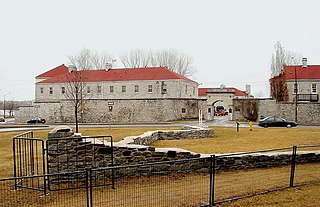
Fort Henry National Historic Site is located in Kingston, Ontario, Canada on Point Henry, a strategic, elevated point near the mouth of the Cataraqui River where it flows into the St. Lawrence River at the east end of Lake Ontario. The fort and the point on which the fort was built were named after Henry Hamilton, former Lieutenant-Governor of the Province of Quebec.
Fort Frontenac was a French trading post and military fort built in July 1673 at the mouth of the Cataraqui River where the St. Lawrence River leaves Lake Ontario, in a location traditionally known as Cataraqui. It is the present-day location of Kingston, Ontario, Canada. The original fort, a crude, wooden palisade structure, was called Fort Cataraqui but was later named for Louis de Buade de Frontenac, Governor of New France who was responsible for building the fort. It was abandoned and razed in 1689, then rebuilt in 1695.
King's Highway 2, commonly referred to as Highway 2, is the lowest-numbered provincially maintained highway in the Canadian province of Ontario and was originally part of a series of identically numbered highways in multiple provinces which together joined Windsor, Ontario to Halifax, Nova Scotia.

Cataraqui Cemetery is a cemetery located in Kingston, Ontario, Canada. Founded in 1850, it predates Canadian Confederation, and continues as an active burial ground. The cemetery is 91-acres in a rural setting with rolling wooded terrain, ponds and watercourses. More than 46,000 individuals are interred within the grounds, and it is the final resting place of many prominent Canadians, including the burial site of Canada's first prime minister, Sir John A. Macdonald. The Macdonald family gravesite, and the cemetery itself, are both designated as National Historic Sites of Canada.

Zoombezi Bay is a 22.7 acre water park owned by the Columbus Zoo and Aquarium near Powell, Ohio just north of Columbus. The park sits on the site of the former Wyandot Lake Amusement Park, which was purchased by the Columbus Zoo and Aquarium in 2006. Zoombezi Bay opened to the public on May 26, 2008, and currently ranks as one of the Midwest's most popular water parks, attracting more than 400,000 visitors annually.

The Kingston railway station is an inter-city passenger rail station in Cataraqui, Kingston, Ontario, Canada. It is served by Via Rail trains running from Toronto to Ottawa or Montreal, along the Corridor route. It is located on John Counter Boulevard, northeast of Princess Street and north-west of downtown Kingston.
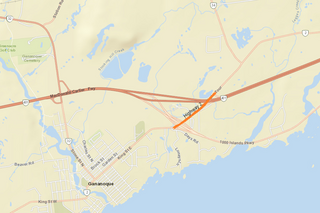
King's Highway 15, commonly referred to as Highway 15, is a provincially maintained highway in the Canadian province of Ontario. It currently travels north from an interchange with Highway 401 in Kingston to Highway 7 in Carleton Place, but once continued east from there into Ottawa until that section became part of Highway 7. The length of Highway 15 is 113.4 kilometres (70.5 mi).
Cataraqui Golf and Country Club is a private golf and curling club located in Kingston, Ontario, Canada. It was founded in 1917.

Carleton Island is located in the St Lawrence River in upstate New York. It is part of the Town of Cape Vincent, in Jefferson County.
King's Highway 38, commonly referred to as Highway 38, was a provincially maintained highway in the Canadian province of Ontario. The road connects highways 2 and 401 in Kingston with Highway 7 west of Perth.

Lemoine Point Conservation Area is a 136 hectare recreational conservation area at the west end of Kingston, Ontario. The area is bordered by Collins Bay on the north and west sides, Lake Ontario on the south and Kingston/Norman Rogers Airport on the east.

Kingston City Hall is the seat of local government in Kingston, Ontario, Canada. Occupying a full city block facing Lake Ontario in Kingston's downtown, the city hall is a prominent building constructed in the Neoclassical style with a landmark tholobate and dome.
Point Frederick is a 41-hectare (101-acre) peninsula in Kingston, Ontario, Canada. The peninsula is located at the south end of the Rideau Canal where Lake Ontario empties into the St. Lawrence River. Point Frederick is bounded by the Cataraqui River to the west, the St. Lawrence River to the south, and Navy Bay to the east. The peninsula is occupied by the Royal Military College of Canada (RMC). Several of the buildings located on Point Frederick and the site of the old naval dockyard are national historic sites. Fort Frederick, at the south end of the peninsula, is a feature of the Kingston Fortifications National Historic Site of Canada.
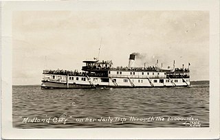
SS Midland City was originally a Canadian side-wheel steamboat that provided passenger and cargo transportation on the Great Lakes from 1871 until 1955. Originally named Maud, then America, she underwent several extensive refits over her 84-year service, and saw several owners. The ship was intentionally run aground and burnt to the waterline in 1955 near the mouth of the Wye River in Midland Bay. The wreck is intact and visible above the water to this day, where it acts as a breakwater for the Wye Heritage Marina and local attraction.


