McDowell County is a county located in the U.S. state of North Carolina. As of the 2020 census, the population was 44,578. Its county seat is Marion.

Marion is a city in and the county seat of McDowell County, North Carolina, United States. Founded in 1844, the city was named in honor of Brigadier General Francis Marion, the American Revolutionary War Hero whose talent in guerrilla warfare earned him the name "Swamp Fox". Marion's Main Street Historic District is listed on the National Register of Historic Places. The population was 7,717 at the 2020 Census.
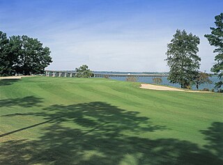
Santee is a town in Orangeburg County along the Santee River Valley in central South Carolina, United States. It has become a resort town of note located centrally north-south along the Atlantic Seaboard of South Carolina. The region has been rural, with a primarily agricultural economy typical of Orangeburg County, but is now known primarily for its several golf courses in proximity to Lake Marion, Santee State Park and other Lake Marion attractions. Interstate 95 connects its attractions easily with tourists traveling by automobile. I-95 crosses a narrow arm of the lake into the town lands, along a causeway. Lake Marion is a man-made hydroelectric reservoir, which at 110,000 acres is one of the fifty largest lakes in the country.

Maple Valley is a city in King County, Washington United States. The population was 28,013 at the 2020 census. The city functions as a commuter town for residents, though there is an increasing amount of commercial activity in the area.
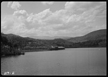
The Santee River is a river in South Carolina in the United States, and is 143 miles (230 km) long. The Santee and its tributaries provide the principal drainage for the coastal areas of southeastern South Carolina and navigation for the central coastal plain of South Carolina, emptying into the Atlantic Ocean about halfway between Myrtle Beach and Charleston near the community of McClellanville. The farthest headwaters are 440 miles (708 km) away on the Catawba River in North Carolina. Besides the Catawba, other principal rivers of the Santee watershed include the Congaree, Broad, Linville, Saluda and the Wateree. The watershed drains a large portion of the Piedmont regions of South and North Carolina. The Santee River is the second largest river on the eastern coast of the United States, second only to the Susquehanna River in drainage area and flow. Much of the upper river is impounded by the expansive, horn-shaped Lake Marion reservoir, formed by the 8-mile (13 km)-long Santee Dam. The dam was built during the Great Depression of the 1930s as a Works Progress Administration (WPA) project to provide a major source of hydroelectric power for the state of South Carolina.

Homewood is an unincorporated community of about 200 residents, in Placer County, California, located on the west shore of Lake Tahoe. It is located 5.5 miles (8.9 km) south of Tahoe City and north of Chambers Landing and Tahoma. It is the location of Homewood Mountain Resort.
Tahoma is a name for the volcano otherwise known as Mount Rainier.

Tahoma School District No. 409 (TSD) is a public school district headquartered in Maple Valley, Washington. The district provides for citizens within southeast King County, and operates 6 elementary schools, 2 middle schools, and the district's singular high school, Tahoma High School. Approximately 9,300 students are served by the district (2023-2024), which covers the entirety of Maple Valley, Ravensdale, and Hobart, portions of Renton, Covington, and Black Diamond, and a significant area of unincorporated King County. The district is bordered by Enumclaw School District to the south, Snoqualmie Valley School District to the east, Issaquah School District to the north, Renton School District to the northwest, and Kent School District to the west.

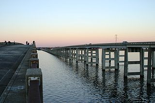
Interstate 95 (I-95) is a major Interstate Highway, running along the East Coast of the United States from Florida to Maine. In South Carolina, I-95 runs approximately parallel to the Atlantic Ocean shore although about 50 miles (80 km) inland, from Hardeeville in the south to Dillon in the northeast. The route runs through the cities of Florence and Walterboro.

Lake Moultrie is a large man-made lake in South Carolina. Created in the 1940s by a state utility project to provide electricity to rural SC by damming the Santee River, it covers more than 60,000 acres (240 km2). The third largest lake in the state, it provides a wide variety of recreational opportunities, including fishing.

USCGC Tahoma (WPG-80) was a United States Coast Guard Cutter built by the Defoe Shipbuilding Company in Bay City, Michigan. Completed in 1934, the steel-hulled cutter operated on the Great Lakes between 1934 and 1941, attached to the 9th Coast Guard District and homeported at Cleveland, Ohio. She was named after the Tahoma Glacier on the western slope of Mount Rainier in the state of Washington.

U.S. Highway 15 (US 15) is a 158.832-mile (255.615 km) United States Numbered Highway in the eastern part of the U.S. state of South Carolina. It is a north–south highway that travels from Walterboro to the North Carolina state line, north-northeast of McColl.

U.S. Route 301 (US 301) is a 189.704-mile (305.299 km) U.S. Highway that travels north–south from the Savannah River southwest of Allendale to Hamer approaching the South of the Border roadside attraction complex.
Tahoma is a census-designated place in Placer and El Dorado counties, California, United States. Tahoma is located along Lake Tahoe 2 miles (3.2 km) southeast of Homewood. Tahoma has a population of 1,191.

North Carolina Highway 80 (NC 80) is a primary state highway in the U.S. state of North Carolina. The highway connects the various mountain communities straddled along Buck Creek, South Toe River and North Toe River in Western North Carolina and serves as a direct route, via the Blue Ridge Parkway, to Mount Mitchell State Park.

South Carolina Highway 41 (SC 41) is a 121.5-mile (195.5 km) state highway, connecting the Charleston region with eastern portions of the Pee Dee region in South Carolina. It serves as an alternative route to U.S. Route 52.
A civil emergency message is a warning issued through the Emergency Alert System (EAS) in the United States to warn the public of a significant in-progress or imminent threat or danger to public safety. It is typically issued by a local or state authority and is relayed by the National Weather Service. The warning is a higher priority than a local area emergency (LAE), but it's less specific than a civil danger warning (CDW). For example, the warning could be used to describe an alert issued by the National Terrorism Advisory System.
Shadow Lake is a census-designated place (CDP) in King County, Washington, United States. The population was 2,262 at the 2010 census.

South Carolina Highway 341 (SC 341) is a 93.870-mile (151.069 km) state highway that travels through the northeastern part of the U.S. state of South Carolina. It travels diagonally from the southeast to northwest from SC 41 and SC 51 in Johnsonville to U.S. Route 521 Business and US 601 Bus. in Kershaw.
North Santee is a census-designated place (CDP) in Clarendon County, South Carolina, United States. It was first listed as a CDP prior to the 2020 census with a population of 749.