
The Great Victoria Desert is a sparsely populated desert ecoregion and interim Australian bioregion in Western Australia and South Australia.

The Simpson Desert is a large area of dry, red sandy plain and dunes in the Northern Territory, South Australia and Queensland in central Australia. It is the fourth-largest Australian desert, with an area of 176,500 km2 (68,100 sq mi).

The Great Central Road is a mostly unsealed Australian outback highway that runs 1,126 km (700 mi) from Laverton, Western Australia to Yulara, Northern Territory. It passes through a number of small communities on the way. It forms part of the Outback Way which goes all the way to Winton, Queensland.
Desert exploration is the deliberate and scientific exploration of deserts, the arid regions of the earth. It is only incidentally concerned with the culture and livelihood of native desert dwellers. People have struggled to live in deserts and the surrounding semi-arid lands for millennia. Nomads have moved their flocks and herds to wherever grazing is available, and oases have provided opportunities for a more settled way of life. Many, such as the Bushmen in the Kalahari, the Aborigines in Australia and various Indigenous peoples of the Americas, were originally hunter-gatherers. Many trade routes have been forged across deserts, especially across the Sahara Desert, and traditionally were used by caravans of camels carrying salt, gold, ivory and other goods. Large numbers of slaves were also taken northwards across the Sahara. Today, some mineral extraction also takes place in deserts, and the uninterrupted sunlight gives potential for the capture of large quantities of solar energy.

Strzelecki Track is a mostly unsealed outback track in South Australia, linking Innamincka to Lyndhurst.
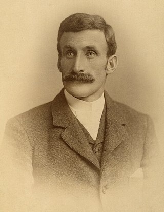
Lawrence Allen "Larry" Wells, frequently spelled Laurence Allen Wells, was an Australian explorer.

David Lindsay was an Australian explorer and surveyor and a fellow of the Royal Geographical Society, London.

The Gobi Desert is a large, cold desert and grassland region in northern China and southern Mongolia and is the sixth largest desert in the world. The name of the desert comes from the Mongolian word Gobi, used to refer to all of the waterless regions in the Mongolian Plateau, while in Chinese Gobi is used to refer to rocky, semi-deserts such as the Gobi itself rather than sandy deserts.

Neale Junction is an isolated location in the Great Victoria Desert of Western Australia, where the Anne Beadell and Connie Sue Highways intersect. It is 172 km (107 mi) west of Ilkurlka. Neale Junction was named after Commander Frank Neale, who flew a Percival Gull through the area during the Mackay Aerial Reconnaissance Survey Expedition to Western and South Australia in 1935.
Fraser Range Station is a pastoral lease and sheep station located about 100 kilometres (62 mi) east of Norseman on the Eyre Highway in the Goldfields-Esperance region of Western Australia.

The Calvert Scientific Exploring Expedition took place in central and northern Western Australia in 1896 and 1897, using camels as the principal means of transport.
Iltur is a remote Pitjantjatjara homeland in the Great Victoria Desert of South Australia. It is also known as Coffin Hill after the rocky outcrop where it is located, and the traditional country surrounding it is known in Pitjantjatjara as Ilturnga. It is located at the southern end of the Birksgate Range, and is one of the most southerly locations on the Aṉangu Pitjantjatjara Yankunytjatjara Lands. It was visited by the Elder Scientific Exploring Expedition in 1881, led by the explorer David Lindsay.
The Birksgate Range is a scattered range of mountains in the northwest of South Australia. It is located on the northeastern edges of the Great Victoria Desert, spreading for about 100 kilometres (62 mi) from Iltur in the southeast to Watarru in the northwest. The northern portion of it is located within the Watarru Indigenous Protected Area. The range consists of scattered protrusions of granitic rock that have been weathered into rounded and rugged hills. They are not visibly connected to each other, with each outcrop being separated by flat expanses of plains and sand dunes. The mountains are fairly low in elevation; they are highest at the northern end.

The Percival Lakes form a string of S-shaped ephemeral salt lakes in the north of Western Australia. They lie at the southern region of the Great Sandy Desert and east of Karlamilyi National Park. They stretch in an east-west direction for 350 km (220 mi) and north-south for 160 km (99 mi). The surface elevation is 256 m (840 ft). The Canning Stock Route runs in close proximity to some of the lakes, and crosses the salt pan of Tobin Lake near the eastern end. The lakes were named during the aerial expedition of Donald George Mackay in 1933, after the designer of the Percival Gull aircraft being used.

Lake Darlot is an ephemeral lake in the centre of Western Australia, lying approximately 50 km (31 mi) east-north-east of Leinster, and 125 km (78 mi) north of Leonora in the Goldfields-Esperance region. Its surface elevation is 434 metres above mean sea-level.

Yeo Lake is an ephemeral salt lake in the south of Western Australia, lying in the Great Victoria Desert east of Cosmo Newberry. The Anne Beadell Highway runs along its southern margin, and the Great Central Road lies further to its north. Its surface elevation is 349 metres above mean sea-level.
The Ngadju or Ngadjumaya are an Aboriginal Australian people of the Goldfields-Esperance region of Western Australia.
The Yankunytjatjara people, also written Yankuntjatjarra, Jangkundjara, and other variants, are an Aboriginal Australian people of the state of South Australia.

The European exploration of Australia first began in February 1606, when Dutch navigator Willem Janszoon landed in Cape York Peninsula and on October that year when Spanish explorer Luís Vaz de Torres sailed through, and navigated, Torres Strait islands. Twenty-nine other Dutch navigators explored the western and southern coasts in the 17th century, and dubbed the continent New Holland. Most of the explorers of this period concluded that the apparent lack of water and fertile soil made the region unsuitable for colonisation.
Queen Victoria Spring Nature Reserve is a protected area managed by the Department of Parks and Wildlife and is located approximately 200 km (124 mi) east of Kalgoorlie in the Great Victoria Desert in the Goldfields-Esperance region of Western Australia.


