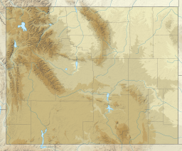
Grand Teton National Park is a national park of the United States in northwestern Wyoming. At approximately 310,000 acres (1,300 km2), the park includes the major peaks of the 40-mile-long (64 km) Teton Range as well as most of the northern sections of the valley known as Jackson Hole. Grand Teton National Park is only 10 miles (16 km) south of Yellowstone National Park, to which it is connected by the National Park Service–managed John D. Rockefeller Jr. Memorial Parkway. Along with surrounding national forests, these three protected areas constitute the almost 18-million-acre (73,000-square-kilometer) Greater Yellowstone Ecosystem, one of the world's largest intact mid-latitude temperate ecosystems.
Scouting in Colorado has a long history, from the 1910s to the present day.
Scouting in Idaho has a long history, from the 1910s to the present day, serving thousands of youth in programs that suit the environment in which they live.

Bighorn Canyon National Recreation Area is a national recreation area established by an act of Congress on October 15, 1966, following the construction of the Yellowtail Dam by the Bureau of Reclamation. It is one of over 420 sites managed by the U.S. National Park Service. The recreation area spans 120,296.22 acres, straddling the border between Wyoming and Montana. It is divided into two distinct areas, the North District accessed via Fort Smith, Montana and the South District accessed through Lovell, Wyoming. There is no thru road inside the recreation area connecting the two districts. The Yellowtail Dam is located in the North District. It is named after the famous Crow leader Robert Yellowtail, harnesses the waters of the Bighorn River by turning that variable watercourse into Bighorn Lake. The lake extends 71 miles (114 km) through Wyoming and Montana, 55 miles (89 km) of which lie within the national recreation area. The lake provides recreational boating, fishing, water skiing, kayaking, and birding opportunities to visitors. About one third of the park unit is located on the Crow Indian Reservation. Nearly one-quarter of the Pryor Mountains Wild Horse Range lies within the Bighorn Canyon National Recreation Area.

The Medicine Bow Mountains are a mountain range in the Rocky Mountains that extend 100 miles (160 km) from northern Colorado into southern Wyoming. The northern extent of this range is the sub-range the Snowy Range. From the northern end of Colorado's Never Summer Mountains, the Medicine Bow mountains extend north from Cameron Pass along the border between Larimer and Jackson counties in Colorado and northward into south central Wyoming. In Wyoming, the range sits west of Laramie, in Albany and Carbon counties to the route of the Union Pacific Railroad and U.S. Interstate 80. The mountains often serve as a symbol for the city of Laramie. The range is home to Snowy Range Ski Area.

Martin's Cove is a historic site in Wyoming. The 933 acre (3.8 km2) cove is located 55 miles (89 km) southwest of Casper, Wyoming, in Natrona County. It is located on the Mormon Trail and is also part of the North Platte-Sweetwater segment of the Oregon Trail. The Cove was listed in the National Register of Historic Places on March 8, 1977.

John D. Rockefeller Jr. Memorial Parkway is a scenic road and protected area that connects Grand Teton National Park and Yellowstone National Park in the U.S. state of Wyoming. It is federally owned and managed by the National Park Service by Grand Teton National Park. It is named in remembrance of John D. Rockefeller Jr., a conservationist and philanthropist who was instrumental in the creation and enlargement of numerous national parks including Grand Teton, Virgin Islands, Acadia and the Great Smoky Mountains. This parkway carries U.S. Route 89, U.S. Route 191, and U.S. Route 287

Caribou–Targhee National Forest is located in the states of Idaho and Wyoming, with a small section in Utah in the United States. The forest is broken into several separate sections and extends over 2.63 million acres (10,600 km2). To the east the forest borders Yellowstone National Park, Grand Teton National Park and Bridger–Teton National Forest. Most of the forest is a part of the 20-million-acre (81,000 km2) Greater Yellowstone Ecosystem.

Founded in 1915, the Greater Los Angeles Area Council (GLAAC) (#033) served most of the City of Los Angeles as well as several other cities in the greater Los Angeles area. It was one of five Boy Scouts of America councils in Los Angeles County, California. Since its founding in 1915, the Los Angeles Area Council has brought its purpose and values to millions of youth. The Council served 54,567 youth in the Greater Los Angeles Area in 2008 alone.
Old Roach is a ghost town in northwestern Larimer County, Colorado, United States. Once a company logging town, occupied roughly between 1923 and 1938, it lies in northern Colorado near the Wyoming border.
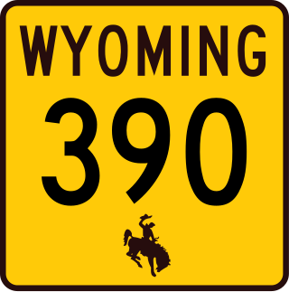
Moose–Wilson Road is a road in the U.S. state of Wyoming; the southern The 7.70 miles (12.39 km) of the road outside of Grand Teton National Park is Wyoming Highway 390 (WYO 390). The road runs about 15 miles (24 km) through the Jackson Hole valley from its intersection with WYO 22 east of Wilson on the south to Moose in Grand Teton National Park on the north end.
Moran is an unincorporated village in south central Teton County, Wyoming, United States: as the community has had two different names, the Board on Geographic Names officially ruled in favor of "Moran" in 1970. It lies in Grand Teton National Park, 29 miles northeast of the city of Jackson, the county seat of Teton County, just northwest by side road of the intersection of U.S. Routes 26, 89, 191 and 287. Its elevation is 6,749 feet (2,057 m) and includes one of the principal entrance-fee collection stations for the Park. Moran also has the post office serving ZIP code of 83013, and a public elementary school; and no other services or businesses.

The AMK Ranch is a former personal retreat on the eastern shore of Jackson Lake in Grand Teton National Park. Also known as the Merymare, Lonetree and Mae-Lou Ranch, it was a former homestead, expanded beginning in the 1920s by William Louis Johnson, then further developed in the 1930s by Alfred Berol (Berolzheimer). Johnson built a lodge, barn and boathouse in 1927, while Berol added a larger lodge, new boathouse, and cabins, all in the rustic style.

Leek's Lodge is part of a former resort and dude ranch in Grand Teton National Park, near Jackson Lake. The ranch was established to offer activities to boys in a frontier setting. Its founder, Steven N. Leek, was instrumental in the establishment of the National Elk Refuge in Jackson Hole. The rustic lodge was built in 1927.
The Trapper Trails Council is a former local council of the Boy Scouts of America that served areas in Northern Utah, Southern Idaho and Western Wyoming serving 18 districts. In April 2020, it combined with the former Great Salt Lake and Utah National Parks councils to create the new Crossroads of the West Council.

The historical buildings and structures of Grand Teton National Park include a variety of buildings and built remains that pre-date the establishment of Grand Teton National Park, together with facilities built by the National Park Service to serve park visitors. Many of these places and structures have been placed on the National Register of Historic Places. The pre-Park Service structures include homestead cabins from the earliest settlement of Jackson Hole, working ranches that once covered the valley floor, and dude ranches or guest ranches that catered to the tourist trade that grew up in the 1920s and 1930s, before the park was expanded to encompass nearly all of Jackson Hole. Many of these were incorporated into the park to serve as Park Service personnel housing, or were razed to restore the landscape to a natural appearance. Others continued to function as inholdings under a life estate in which their former owners could continue to use and occupy the property until their death. Other buildings, built in the mountains after the initial establishment of the park in 1929, or in the valley after the park was expanded in 1950, were built by the Park Service to serve park visitors, frequently employing the National Park Service Rustic style of design.

Flagg Ranch is a privately operated resort located in the John D. Rockefeller Jr. Memorial Parkway corridor between Yellowstone National Park and Grand Teton National Park in northwestern Wyoming. The location was initially occupied in the 1890s by the Snake River Military Station, part of a network of U.S. Army outposts for patrol and management of Yellowstone National Park in its early years under military administration. The outpost operated under Army control until 1906, when the land to the south of the Yellowstone boundary were turned over to the U.S. Forest Service, becoming Teton National Forest in 1908. The station became a stopping point for travelers between Jackson, Wyoming and Yellowstone, easily identifiable by the flags that flew over it.

The M L Ranch was established by Henry Clay Lovell and his financial backer Anthony Mason in Wyoming's Big Horn Basin in the late 1870s to the south of the present location. The second and final location was established farther north as a cattle line camp in 1883 to be closer to markets in Billings, Montana. In 1884 it became the headquarters for a ranch that reached 25,000 acres (10,000 ha) in area. The bad winter of 1886–87 killed half the livestock on the ranch, more than 10,000 head., but the M L fared better than most. Mason died in 1892. Lovell died in Oregon in 1903. Lovell, Wyoming was named in his memory. The Lovell family ran the ranch until 1909. In the early 1960s the ranch was purchased by the Bureau of Reclamation as part of the Bighorn Lake reservoir project. In 1966 the headquarters site was transferred to the National Park Service as part of Bighorn Canyon National Recreation Area.

Terraced Falls ht. 130 feet (40 m) is a waterfall on Fall River in Yellowstone National Park. The highest waterfall on Fall River, Terraced Falls was probably named by the Hague Geological Survey in 1885–1886. An attempt was made to rename it "Totem Falls" in the 1920s, but the USBGN kept the original name. Terraced Falls is easily accessed via a short trail from the Ashton-Flagg Ranch Road along Yellowstone National Park's south border.
The CM Ranch and Simpson Lake Cabins are separate components of a single historic district associated with Charles Cornell Moore, a Fremont County, Wyoming dude ranch operator. The CM ranch, named after Moore, operated as a dude ranch from 1920 to 1942 and resumed operating in 1945. The Simpson Lake Cabins were purchased by Moore in 1931 and were operated as a hunting camp, continuing until 1997 when the CM ranch was sold to new owners and the Simpson Lake property was taken over by the U.S. Forest Service.. The sites are separated by 13 miles (21 km).