
Burfjord is a village that is the administrative centre of Kvænangen Municipality in Troms county, Norway. It is home to the municipal council of Kvænangen. The 0.54-square-kilometre (130-acre) village has a population (2017) of 405 which gives the village a population density of 750 inhabitants per square kilometre (1,900/sq mi).
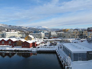
Finnsnes is a small town that is the administrative centre of Senja Municipality in Troms county, Norway. The town is located on the mainland part of Norway, just across the Gisundet strait from the island of Senja. The Gisund Bridge connects Finnsnes to the suburban villages of Silsand and Laukhella on the island of Senja. The municipality is well-provided with kindergartens and a decentralized school system on both primary and secondary levels. There are also three schools on the upper secondary/high school level and a center for decentralized studies at the university level. Finnsnes Church is located in the center of the town.

Mehamn is the administrative centre of Gamvik Municipality in Finnmark county, Norway. The village is located on the small Vedvik peninsula, itself part of the greater Nordkinn Peninsula, at the southern end of the Mehamnfjorden, a bay off of the Barents Sea. The village of Gamvik lies about 16 kilometres (9.9 mi) to the east and the village of Kjøllefjord lies about 30 kilometres (19 mi) to the southwest. Mehamn Chapel is located in this village. The 0.52-square-kilometre (130-acre) village has a population (2017) of 779 which gives the village a population density of 1,498 inhabitants per square kilometre (3,880/sq mi).

Nordkjosbotn (Norwegian) or Gárgán (Northern Sami) is a small village in Balsfjord Municipality in Troms county, Norway. The village lies about 70 kilometres (43 mi) southeast of the city of Tromsø. Two major highways, European route E6 and European route E8, meet in this village, making it a major crossroads in Northern Norway, with an estimated annual passage of 3 million people. The 0.7-square-kilometre (170-acre) village has a population (2017) of 464 which gives the village a population density of 663 inhabitants per square kilometre (1,720/sq mi). Nordkjosbotn Church is located in this village. Macks Ølbryggeri, a brewery, has been operating in Nordkjosbotn since 2012.

Bjerkvik is a village in Narvik Municipality in Nordland county, Norway. The village is located at the end of Herjangsfjorden, an arm of Ofotfjorden. Bjerkvik sits less than 20 kilometres (12 mi) south of the border of Troms county and about 13 kilometres (8.1 mi) across the fjord from the town of Narvik. The 1.34-square-kilometre (330-acre) village has a population (2018) of 1,159 which gives the village a population density of 865 inhabitants per square kilometre (2,240/sq mi).

Furuflaten (Norwegian) or Vuošvággi (Northern Sami) is a village in Lyngen Municipality in Troms county, Norway. The village is located along the Lyngen fjord. Furuflaten is located at the mouth of the Lyngsdalselva river, about 15 kilometres (9.3 mi) south of the village of Lyngseidet and about 54 kilometres (34 mi) straight southeast of the city of Tromsø.
Sørkjosen is a village in Nordreisa Municipality in Troms county, Norway. The village is located along the shores of the Reisafjorden about 5 kilometres (3.1 mi) northwest of the municipal center of Storslett. Sørkjosen has many industries including fishing, dairy production, and a sawmill.

Movik is a village in Tromsø Municipality in Troms county, Norway. It is located along the Tromsøysundet strait on the mainland part of the municipality. The village sits about 10 kilometres (6.2 mi) northeast of the city of Tromsø and about 3.3 kilometres (2.1 mi) north of the village of Kroken. The 0.21-square-kilometre (52-acre) village has a population (2017) of 381 which gives the village a population density of 1,814 inhabitants per square kilometre (4,700/sq mi).

Ersfjordbotn is a village in Tromsø Municipality in Troms county, Norway. The village is located on an isthmus between the Ersfjorden and the Kaldfjorden on the island of Kvaløya. It is about 15 kilometres (9.3 mi) west of the city of Tromsø. The villages of Kjosen and Kvaløysletta are located just to the east of Ersfjordbotn.

Tromsøya (Norwegian) or Romssasuolu (Northern Sami) is an island in Tromsø Municipality in Troms county, Norway. It lies in the Tromsøysundet strait between the mainland and the larger island of Kvaløya. The city of Tromsø is located on the 21.7-square-kilometre (8.4 sq mi) island, which has 39,882 residents. The island is connected to the Tromsdalen area on the mainland to the east by the Tromsø Bridge and Tromsøysund Tunnel, and to the village of Kvaløysletta on Kvaløya island to the west by the Sandnessund Bridge.

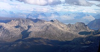
Jiehkkevárri is a mountain on the border of the municipalities of Lyngen and Tromsø in Troms county, Norway. It is the highest mountain in Troms and has the second highest prominence among Norwegian mountains. The 1,834-metre (6,017 ft) tall mountain sits about 10 kilometres (6.2 mi) northeast of the village of Lakselvbukt and about 17 kilometres (11 mi) southwest of the village of Lyngseidet.

Kjosen is a village in Tromsø Municipality in Troms county, Norway. The village lies on the island of Kvaløya, about 13 kilometres (8.1 mi) west of the city of Tromsø. It is located at the end of the Kaldfjorden, immediately north of the village of Kaldfjord. The village of Ersfjordbotn lies about 5 kilometres (3.1 mi) to the west and the village of Kvaløysletta lies about 3 kilometres (1.9 mi) to the east.
Soltindan is the highest mountain on the island of Ringvassøya which is located in Karlsøy Municipality in Troms county, Norway. It is located just north of the border with Tromsø Municipality, about 14 km (8.7 mi) southwest of the village of Hansnes. The 1,051-metre (3,448 ft) mountain has a topographic prominence of 1,051 metres (3,448 ft) and a topographic isolation of 16 kilometres (9.9 mi). Just to the north of the peak is the small glacial lake, Brevatnet.
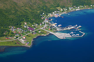
Botnhamn is a village in Senja Municipality in Troms county, Norway. The small village is located more than 300 kilometres (190 mi) north of the Arctic Circle on the northern part of the large island of Senja. The village lies along the west side of the Stønnesbotn fjord. The population (2001) is 308. Botnhamn experiences warm summers and long, dark winters. Botnhamn is located about 28 kilometres (17 mi) northwest of the village of Gibostad and 52 kilometres (32 mi) northwest of the town of Finnsnes.

Store Fornestinden is a mountain in Tromsø Municipality in Troms county, Norway. The highest peak of any mountain in the eastern part of the municipality. The 1,477-metre (4,846 ft) tall mountain lies about 40 kilometres (25 mi) east of the city of Tromsø and about 11 kilometres (6.8 mi) west of the village of Lyngseidet in the neighboring Lyngen Municipality. The mountain is on the southern shore of the Kjosen fjord, an arm of the large Ullsfjorden.

Harstad is a town in Harstad Municipality in Troms county, Norway. The town is also the administrative centre of the municipality of Harstad. The 11.15-square-kilometre (2,760-acre) town has a population (2017) of 20,953 which gives the town a population density of 1,879 inhabitants per square kilometre (4,870/sq mi). It is the second-largest town in Troms county, after the city of Tromsø, and it is the largest town in Central Hålogaland.

Ullsfjorden (Norwegian) or Moskavuotna (Northern Sami) is a fjord in Troms county, Norway. The fjord runs through the municipalities of Tromsø, Karlsøy, and Lyngen. The 75-kilometre (47 mi) fjord flows from the village of Sjøvassbotn northwards along the west side of the Lyngen Peninsula. The Kjosen fjord branches off to the east side and the Grøtsundet strait branches off to the west. The islands of Reinøya and Karlsøya lie along the western side of the fjord. The southern part of the Ullsfjorden is also known as Sørfjorden. The area surrounding the Ullsfjorden was part of the municipality of Ullsfjord for about 60 years during the 20th century.

Kroken is a neighborhood in the city of Tromsø which lies in Tromsø Municipality in Troms county, Norway. The neighborhood is located along the Tromsøysundet strait on the mainland, just across the strait from the city centre of Tromsø which lies on the island of Tromsøya. The Tromsdalen area of the city of Tromsø lies about 4 kilometres (2.5 mi) to the south and the village of Movik lies about 3 kilometres (1.9 mi) to the north. The village is considered part of the Tromsdalen urban area.
Mjølvik is a small, isolated fishing village in Tromsø Municipality in Troms county, Norway. The small village lies on the southeast side of the island of Sandøya, about 45 kilometres (28 mi) northwest of the city of Tromsø. The village is only accessible by boat. There is a ferry that stops at the village three times each week. There are three residents of Mjølvik.

Jøvik is a village in Tromsø Municipality in Troms county, Norway. The village is located along the Ullsfjorden on the Lyngen peninsula, about 35 kilometres (22 mi) east of the city of Tromsø, but it is about 100 kilometres (62 mi) to drive there. The proposed Ullsfjord Bridge would cross the Ullsfjorden near Jøvik, reducing the travel time to central Tromsø by half. The village has road access via the Fv293 road to the village of Lakselvbukt to the south and further to the European route E8 highway. Before the road was built in the 1970s a ferry went from Jøvik to Breivikeidet.


