Lakså, Fauske

Last updated
Lakså
Village

Laksa seen from Tverrstigfjellet.jpg

Lakså seen from the hill Tverrstigfjellet. The Laksåga River empties into Lakså Bay.
Norway Nordland location map.svg
Red pog.svg
Lakså
Location in Nordland
Norway location map.svg
Red pog.svg
Lakså
Lakså (Norway)
Coordinates: 67°14′16″N15°41′57″E / 67.23778°N 15.69917°E / 67.23778; 15.69917 Coordinates: 67°14′16″N15°41′57″E / 67.23778°N 15.69917°E / 67.23778; 15.69917
Country Norway
Region Northern Norway
County Nordland
District Salten
Municipality Fauske
Elevation [1] 4 m (13 ft)
Time zone CET (UTC+01:00)
  Summer (DST) CEST (UTC+02:00)
Post Code8200 Fauske

Lakså (Lule Sami : Laksoavvo) [2] [3] is an abandoned village with no road connection in a valley above Øvervatnet (English: Upper Lake) in the municipality of Fauske in Nordland county, Norway. There were two farms in the valley: Lakså on the shore of Lakså Bay (Norwegian : Laksåbukta) and Nordal (or Norddal) somewhat further up the valley. [4]

Lule Sami language language

Lule Sámi language(julevsámegiella) is a Uralic, Sámi language spoken in Lule Lappmark, i.e. around the Lule River, Sweden and in the northern parts of Nordland county in Norway, especially Tysfjord municipality, where Lule Sámi is an official language. It is written in the Latin script, having an official alphabet.

Fauske Municipality in Nordland, Norway

Fauske (Norwegian) or Fuossko (Lule Sami) is a municipality located in Nordland county, Norway. It is part of the traditional district of Salten. The administrative centre of the municipality is the town of Fauske. Some of the villages in Fauske include Nystad, Venset, Straumsnes, and Sulitjelma.

Nordland County (fylke) of Norway

Nordland is a county in Norway in the Northern Norway region, bordering Troms in the north, Trøndelag in the south, Norrbotten County in Sweden to the east, Västerbotten County to the southeast, and the Atlantic Ocean to the west. The county was formerly known as Nordlandene amt. The county administration is in Bodø. The remote Arctic island of Jan Mayen has been administered from Nordland since 1995.

History

The Lakså farm was first mentioned in the rent-roll and census of 1665–1666, where it is referred to as Laxaaen Øegaard. Later, in 1801, several farms were mentioned in the valley: Laxaae, Nordre Laxaae, and Lieland or Laxaaenbakken. At that time there was also a farm further out along the bay called Laxaaemark, later known as Skognes. [5] :22–25 With the establishment of the municipality of Fauske on January 1, 1905, the Lakså farm was assigned the number 93, Nordal (Lakså nordre) was numbered 94, and Skognes (Laksåmark) was numbered 95. [5] :20

Urbarium register of fief ownership and includes the rights and benefits that the fief holder has over his serfs and peasants

An urbarium, is a register of fief ownership and includes the rights and benefits that the fief holder has over his serfs and peasants. It is an important economic and legal source of medieval and early modern feudalism.

Mons Petter (1807–1888), an impoverished Sami known for having found copper ore in Sulitjelma, came from the Skognes farm in Lakså. [6]

Mons Andreas Petersen, best known as Mons Petter, was a Norwegian Sami farmer that discovered ore deposits in Sulitjelma in 1858.

Sulitjelma Village in Northern Norway, Norway

Sulitjelma (Norwegian), Sulisjielmmá (Lule Sami), or Sulitelma (Swedish) is a village in the municipality of Fauske in Nordland county, Norway. Sulitjelma is situated in a lush inland valley at an elevation of 140 metres (460 ft) above sea level. It is located on the shore of Langvatnet lake, about 35 kilometres (22 mi) southeast of the town of Fauske. The lakes Låmivatnet, Kjelvatnet, and Muorkkejávrre are located to the east and south of the village.

In 1957, the Sulitjelma Line was extended to Finneid; this ended the steamship traffic on Øvervatnet (English: Upper Lake), which was previously used for transport to settlements along the lake. The villages along the lake were isolated for several weeks each fall and spring, when ice formed or thawed on the water and was unsafe for travel. Without the steamships, which had created a navigable stretch of open water through the ice, it was no longer possible to travel with one's own boat. Not only Lakså, but also the smaller villages of Engan and Stifjell were eventually abandoned. [7]

Sulitjelma Line former railway line in Fauske, Norway

The Sulitjelma Line was a railway line that ran between Finneid in the town of Fauske to the village of Sulitjelma near the border with Sweden. The railway line was entirely inside the municipality of Fauske in Nordland county, Norway. The line was built in 1891, over time it was lengthened until 1958 when it was connected to the Nordland Line and the sea port at Finneid. It existed as a branch of the Nordland Line from 1958 until 1972 when the line was closed and removed. The railway line followed the path of the present-day Norwegian County Road 830.

Finneid Town in Northern Norway, Norway

Finneid is a small town with a population of 210 that lies 3 kilometers (1.9 mi) southeast of Fauske in Nordland county, Norway.

The old houses in Lakså and Nordal are used as vacation houses. A construction road was built through the valley in the 1960s as part of building the Siso Hydroelectric Power Station.

The village formerly had its own school.

Related Research Articles

Sulitjelma Glacier glacier in Norway and Sweden

The Sulitjelma Glacier is one of the largest glaciers in mainland Norway. The 24-square-kilometre (9.3 sq mi) glacier is located in mostly in Norway, but the eastern part crosses over into Sweden. The Norwegian part is in Fauske Municipality in Nordland county, about 40 kilometres (25 mi) east of the town of Fauske. The Swedish part lies on the border of Arjeplog Municipality and Jokkmokk Municipality in Norrbotten County. When the whole glacier is considered, it is the largest glacier in Sweden.

Kjelvatnet (Fauske) lake in Fauske, Norway

Kjelvatnet (Norwegian) or Giebbnejávrre or Giebnejávri (Lule Sami) is a lake in Fauske Municipality in Nordland county, Norway. The 3.85-square-kilometre (1.49 sq mi) lake lies about 7 kilometres (4.3 mi) south of the village of Sulitjelma near the border with Junkerdal National Park. Water flows into the lake from the large lake Balvatnet and it flows out of the lake to the north along the Balmi River to the lake Langvatnet.

Låmivatnet lake in Fauske, Norway

Låmivatnet or Loamevatnet  (Norwegian) or Loamejávrre (Lule Sami) is a lake in Fauske Municipality in Nordland county, Norway. The 11.43-square-kilometre (4.41 sq mi) lake lies about 5 kilometres (3.1 mi) east of the village of Sulitjelma, just south of the Sulitjelma Glacier and north of Junkerdal National Park. The border with Sweden is 3 kilometres (1.9 mi) east of the lake. The Lomi Hydroelectric Power Station uses the lake as a reservoir.

Muorkkejávrre lake in Fauske, Norway

Muorkkejávrre (Lule Sami) or Eidevatnet or Eidvatnet (Norwegian) is a lake that lies in Fauske Municipality in Nordland county, Norway. The 5.94-square-kilometre (2.29 sq mi) lake lies about 75 metres (246 ft) west of the border with Sweden and about 10 kilometres (6.2 mi) east of the village of Sulitjelma. The water from the lake flows west into the neighboring lake Låmivatnet. The ending -jávrre is the Lule Sami word for "lake".

Venset Village in Northern Norway, Norway

Venset is a village in the municipality of Fauske in Nordland county, Norway. Venset lies on the north shore of Skjerstad Fjord about 17 kilometers (11 mi) west of the town of Fauske and about 6 kilometres (3.7 mi) south of the village of Valnesfjord.

Sulitjelma (mountain) massif along the Norway-Sweden border

Sulitjelma is a mountain massif on the Norway-Sweden border in the municipality of Fauske in Nordland, Norway and the municipality of Arjeplog in Norrbotten, Sweden. The massif lies east of the village of Sulitjelma, which takes its name from the mountain. The massif is bordered by Låmivatnet and Muorkkejávrre to the south, and by Bajep Sårjåsjávrre and Vuolep Sårjåsjávrre to the north. About two-thirds of the mountain is in Norway. The Langvann Valley extends toward the massif along a northwest-southeast axis, through which the Sjønstå River flows, forming the Sulitjelma watercourse. The valley starts at the village of Sjønstå on Øvervatnet, which lies about 17 kilometers (11 mi) east of the village of Sulitjelma itself.

Sjønstå River river in Fauske, Norway

The Sjønstå River is a river in the municipality of Fauske in Nordland county, Norway. The river is located in the valley between the town of Fauske and the village of Sulitjelma.

Sjønstå Village in Northern Norway, Norway

Sjønstå is a settlement in Norway and was officially a village during a brief time when Sulitjelma Mines carried out activity in the area, c. 1890 to 1956. Before this time, Sjønstå comprised the Sjønstå farm, which is located on Øvervatnet in the municipality of Fauske in Nordland county.

Fossen (Fauske) waterfall in Fauske, Norway

Fossen is a waterfall along the Sjønstå River in Nordland county, Norway. It is about 9 kilometers (5.6 mi) upriver from the Sjønstå farm in the municipality of Fauske.

Lomi Hydroelectric Power Station building in Fauske, Northern Norway

The Lomi Hydroelectric Power Station is a hydroelectric power station in the municipality of Fauske in Nordland county, Norway. It utilizes a drop of 580 meters (1,900 ft) between its intake reservoir on Låmivatnet, which can be regulated at a level between 708 m (2,323 ft) and 649 m (2,129 ft). The reservoir is supplied by water from Storelvvatnan, a lake regulated at a level between 798 m (2,618 ft) and 792 m (2,598 ft), and also by some stream intakes. Part of the water supplying the plant is runoff from the Sulitjelma Glacier. The plant has two Francis turbines and operates at an installed capacity of 120 MW, with an average annual production of about 362 GWh. Its total catchment area is 145 square kilometers (56 sq mi). The plant is owned by Salten Kraftsamband and came into operation in 1979. The water is reused by the Sjønstå Hydroelectric Power Station further downstream in the Sulitjelma drainage system.

Fagerli Hydroelectric Power Station building in Fauske, Northern Norway

The Fagerli Hydroelectric Power Station is a hydroelectric power station in the municipality of Fauske in Nordland county, Norway. It utilizes a drop of 232 meters (761 ft) between its intake reservoir at Nedre Daja and Langvatnet in Sulitjelma. The plant operates at an installed capacity of 48 MW, with an average annual production of about 252 GWh. It is owned by Salten Kraftsamband and came into operation in 1975. The Fagerli plant was the first one built by Salten Kraftsamband, in cooperation with Sulitjelma Mines.

Balmi River river in Fauske, Norway

The Balmi River is a river in the municipality of Fauske in Nordland county, Norway. It flows about 6.5 km (4.0 mi) from one lake and empties into another: from Kjelvatnet at an elevation of 510 meters (1,670 ft) north to Langvatnet at an elevation of 127 meters (417 ft). The river has a drainage basin of 439 square kilometers (169 sq mi). The river is located a short distance south of the village of Sulitjelma and about 35 kilometres (22 mi) southeast of the Fauske.

Daja Hydroelectric Power Station building in Sulitjelma, Northern Norway

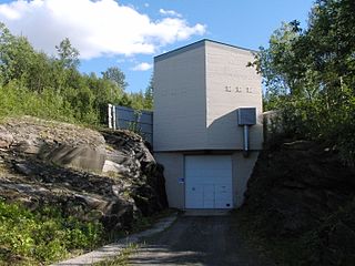
The Daja Hydroelectric Power Station is a hydroelectric power station in the municipality of Fauske in Nordland county, Norway. It is located about 2.3 kilometers (1.4 mi) east-southeast of Jakobsbakken.

Fauske (town) Town in Northern Norway, Norway

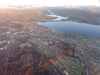
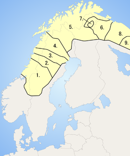
Fauske is a town in Fauske Municipality in Nordland county, Norway. It is also the administrative centre of Fauske Municipality. The town is located on the shore of the Skjerstad Fjord, about 60 kilometres (37 mi) east of the town of Bodø and about 40 kilometres (25 mi) west of the border with Sweden. The lake Nervatnet lies on the southeast side of the town.

Sulitjelma Mines mining company in Fauske, Norway

Sulitjelma Mines was a Norwegian mining company that extracted copper, pyrite, and zinc at Sulitjelma in the municipality of Fauske, Norway. Operations started with a test mine in 1887. From 1891 to 1933, the business was registered as a Swedish company called Sulitelma Aktiebolags Gruber. From 1933 to 1983, it was registered as a Norwegian company called A/S Sulitjelma Gruber, and from 1983 until it was shut down in 1991 the company was state-owned and was named Sulitjelma Bergverk AS.

References

  1. "Lakså, Fauske (Nordland)" (in Norwegian). yr.no . Retrieved December 25, 2016.
  2. Stedsnavnliste over pitesamiske stedsnavn. Árran. Revidert liste 26.6.14., no. 93.
  3. Qvigstad, Just Knut. 1893. Nordische Lehnwörter im Lappischen (= Forhandlinger i Videnskabs-selskabet i Christiania). Christiania: Grøndahl & Søn, p. 250.
  4. Salten jordskifterett. Årsmelding 2004. 2004. p. 2.
  5. 1 2 Berg, Gunnar. 1975. Bygdebok for Skjerstad og Fauske. Bodø: Nordland Boktrykkeri A/S.
  6. Enge, Kåre. 1991. Han Mons Petter. Fauskeboka 1991, p. 43. Fauske: Fauske Kulturstyre.
  7. Strøm, John. 1993. Vandring langs gjengrodde stier på Stifjell. Fauskeboka 1993, p. 43. Fauske: Fauske Kulturstyre.