
Nordland is one of the three northernmost counties in Norway in the Northern Norway region, bordering Troms in the north, Trøndelag in the south, Norrbotten County in Sweden to the east, Västerbotten County to the south-east, and the Atlantic Ocean to the west. The county was formerly known as Nordlandene amt. The county administration is in the town of Bodø. The remote Arctic island of Jan Mayen has been administered from Nordland since 1995. In the southern part of the county is Vega, listed on the UNESCO World Heritage Site list.

(Norwegian) or Fuossko (Lule Sami) is a municipality located in Nordland county, Norway. It is part of the traditional district of Salten. The administrative centre of the municipality is the town of Fauske. Some of the villages in Fauske include Nystad, Venset, Straumsnes, Sjønstå, Valnesfjord, Finneid, and Sulitjelma.
The Dunderland Valley is a valley in Rana Municipality in Nordland county, Norway. It reaches from just below the eastern Saltfjellet plateau about 8 miles (13 km) south of the Arctic Circle. The mountain Bolna is situated in the uppermost boundary of the valley which then proceeds to the southwest all the way down to the Ranfjorden. Some of the minor side valleys include Plurdalen, Røvassdalen, Bjøllådalen, Grønfjelldalen and Virvassdalen. The valley also includes several villages such as Krokstrand, Bjøllånes, Storvoll, Dunderland, Eiterå, Nevernes, Storforshei, Nevermoen and Røssvoll.

Bjørnevatn (Norwegian), Kuõbǯǯjäuʹrr (Skolt Sami), Guovžajávri (Northern Sami), or Kruuvakylä (Kven) is a village in Sør-Varanger Municipality in Finnmark county, Norway. The village lies about 8 kilometres (5.0 mi) south of the town of Kirkenes and about 3.8 kilometres (2.4 mi) west of the Norway-Russia border. The village has a couple of suburbs including Hesseng to the north and Sandnes to the west. The Bjørnevatn IL is the local sports team. The name Bjørnevatn translates to "Bear Lake" in English.
Kjelvatnet (Norwegian) or Giebbnejávrre (Lule Sami) is a lake in Fauske Municipality in Nordland county, Norway. The 3.85-square-kilometre (1.49 sq mi) lake lies about 7 kilometres (4.3 mi) south of the village of Sulitjelma near the border with Junkerdal National Park. Water flows into the lake from the large lake Balvatnet and it flows out of the lake to the north along the Balmi River to the lake Langvatnet.
Langvatnet is a lake that lies in Fauske Municipality in Nordland county, Norway. The 5.46-square-kilometre (2.11 sq mi) lake lies about 25 kilometres (16 mi) east of the town of Fauske. The village of Sulitjelma lies on the northeastern edge of the lake. Water from the lakes Kjelvatnet and Låmivatnet flow into the lake from the south and east. The water from Langvatnet flows out through the Sjønstå River to the west towards the lake Øvrevatnet.
Lomivatnet (Norwegian) or Loamejávrre (Lule Sami) is a lake in Fauske Municipality in Nordland county, Norway. The 11.43-square-kilometre (4.41 sq mi) lake lies about 5 kilometres (3.1 mi) east of the village of Sulitjelma, just south of the Sulitjelma Glacier and north of Junkerdal National Park. The border with Sweden is 3 kilometres (1.9 mi) east of the lake. The Lomi Hydroelectric Power Station uses the lake as a reservoir.

The Sulitjelma Line was a railway line that ran between Finneid in the town of Fauske to the village of Sulitjelma near the border with Sweden. The railway line was entirely inside Fauske Municipality in Nordland county, Norway. The line was built in 1891, over time it was lengthened until 1958 when it was connected to the Nordland Line and the sea port at Finneid. It existed as a branch of the Nordland Line from 1958 until 1972 when the line was closed and removed. The railway line followed the path of the present-day Norwegian County Road 830.
Suliskongen is a mountain in Fauske Municipality in Nordland county, Norway. The 1,908-metre (6,260 ft) tall mountain is part of the Sulitjelma massif and it is the second highest mountain in Northern Norway. It is located about 17 kilometres (11 mi) east of the village of Sulitjelma and the peak of the mountain lies less than 900 metres (3,000 ft) west of the border with Sweden. The Sulitjelma Glacier lies on the mountain.
Jakobsbakken is a small clustered village area in Fauske Municipality in Nordland county, Norway. The village no longer has any permanent residents, but it historically was a mining village. The village is situated south of Lake Langvatnet, about 8 kilometres (5.0 mi) south of the village of Sulitjelma, just above the tree line at an elevation of 600 meters (2,000 ft).
Lakså (Norwegian) or Láksoavvo (Lule Sami) is a small village in Fauske Municipality in Nordland county, Norway. The village has no permanent residents anymore due to its lack of a road connection. Many of the existing homes in the village are now used as holiday cottages. It is located in a valley on the north shore of the lake Øvervatnet, about 17 kilometres (11 mi) east of the town of Fauske. There were two farms in the valley: Lakså on the shore of Lakså Bay and Nordal somewhat further up the valley.
Mons Andreas Petersen, best known as Mons Petter, was a Norwegian Sami farmer that discovered ore deposits in Sulitjelma in 1858.
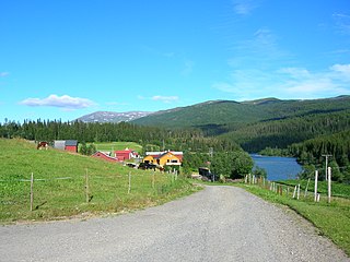
Venset is a village in Fauske Municipality in Nordland county, Norway. Venset lies on the north shore of Skjerstad Fjord about 17 kilometers (11 mi) west of the town of Fauske and about 6 kilometres (3.7 mi) south of the village of Valnesfjord.

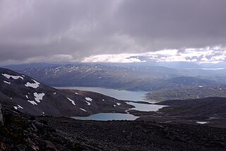
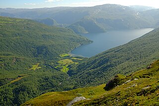
Sulitjelma is a mountain massif on the Norway-Sweden border in Fauske Municipality in Nordland county, Norway and Arjeplog Municipality in Norrbotten County, Sweden. The massif lies east of the village of Sulitjelma, which takes its name from the mountain. The massif is bordered by Låmivatnet and Muorkkejávrre to the south, and by Bajep Sårjåsjávrre and Vuolep Sårjåsjávrre to the north. About two-thirds of the mountain is in Norway. The Langvann Valley extends toward the massif along a northwest–southeast axis, through which the Sjønstå River flows, forming the Sulitjelma watercourse. The valley starts at the village of Sjønstå on Øvervatnet, which lies about 17 kilometers (11 mi) east of the village of Sulitjelma itself.

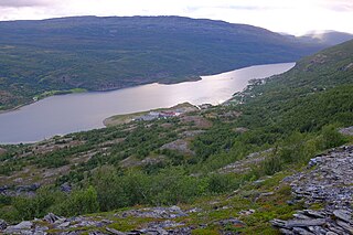
Sjønstå (Norwegian) or Sjenståhka (Lule Sami) is a village in Fauske Municipality in Nordland county, Norway. It is located at the southeastern shore of the lake Øvervatnet, about 20 kilometres (12 mi) east of the town of Fauske. The village peaked in size during a brief time when the Sulitjelma Mines carried out lots of activity in the area, c. 1890 to 1956. Before this time, Sjønstå was just a small farm area.
Finneid is a neighborhood in the eastern part of the town of Fauske, located within Fauske Municipality in Nordland county, Norway. The area had a population of 210. The area is located along the Fauskevika bay on the Skjerstadfjorden. The lake Nervatnet empties into the fjord just south of Finneid.
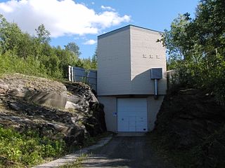
The Daja Hydroelectric Power Station is a hydroelectric power station in Fauske Municipality in Nordland county, Norway. It is located about 2.3 kilometers (1.4 mi) east-southeast of Jakobsbakken.
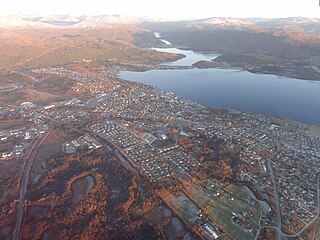
(Norwegian) or Fuossko (Lule Sami) is a town in Fauske Municipality in Nordland county, Norway. It is also the administrative centre of Fauske Municipality. The town is located on the shore of the Skjerstad Fjord, about 60 kilometres (37 mi) east of the town of Bodø and about 40 kilometres (25 mi) west of the border with Sweden. The lake Nervatnet lies on the southeast side of the town.

Badderen (Norwegian), Báttár (Northern Sami), or Paattari (Kven) is a village in Kvænangen Municipality in Troms county, Norway. It lies at the head of the Badderfjord, about 13 kilometers (8.1 mi) south of the municipal seat of Burfjord. The European route E6 highway passes through the village. The basic statistical unit (grunnkrets) of Badderen, which also includes the hamlet of Undereidet, had a population of 183 in 2015.

Sulitjelma Mines was a Norwegian mining company that extracted copper, pyrite, and zinc at Sulitjelma in Fauske Municipality in Nordland county, Norway. Operations started with a test mine in 1887. From 1891 to 1933, the business was registered as a Swedish company called Sulitelma Aktiebolags Gruber. From 1933 to 1983, it was registered as a Norwegian company called A/S Sulitjelma Gruber, and from 1983 until it was shut down in 1991 the company was state-owned and was named Sulitjelma Bergverk AS.


