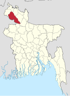
Dinajpur district is a district in the Rangpur Division of northern Bangladesh. Dinajpur is the largest district among all sixteen northern districts of Bangladesh.

Rangpur is a district in Northern Bangladesh. It is a part of the Rangpur Division.

Tajhat Palace, Tajhat Rajbari, is a historic palace of Bangladesh, located in Tajhat, Rangpur. This palace now holds the Rangpur museum. Tajhat Palace is situated three km. south-east of the city of Rangpur, on the outskirts of town.

Biral is an Upazila of Dinajpur District in the Division of Rangpur, Bangladesh.
Bochaganj is an Upazila of Dinajpur District in the Division of Rangpur, Bangladesh. Aynul Bari
Ghoraghat is an Upazila of Dinajpur District in the Division of Rangpur, Bangladesh.
Kaharole is an Upazila of Dinajpur District in the Division of Rangpur, Bangladesh.
Khansama is an upazila of Dinajpur District in the Division of Rangpur, Bangladesh.
Dinajpur Sadar is an Upazila of Dinajpur District in the Division of Rangpur, Bangladesh.
Saghata is an Upazila of Gaibandha District in the Division of Rangpur, Bangladesh. Village=shimultair Post=Bonarpara
Rajarhat is an upazila of Kurigram District in the Division of Rangpur, Bangladesh. Since 1981 it had been a Thana and later on September 14, 1983 was turned into an upazila by the government.
Nilphamari Sadar is an Upazila of Nilphamari District in the Division of Rangpur, Bangladesh.
Saidpur is an Upazila of Nilphamari District in the Division of Rangpur, Bangladesh.
Badarganj is an upazila of Rangpur District in the Division of Rangpur, Bangladesh.
Rangpur Sadar is an Upazila of Rangpur District in the Division of Rangpur, Bangladesh.
Mithapukur is an upazila of Rangpur District in the division of Rangpur, Bangladesh. The upazila is situated in the middle of Rangpur, surrounded by Rangpur Sadar to the north, Pirganj to the south, Badarganj and Phulbari to the west and Pirgachha and Sundarganj to the east. Mithapukur is famous for being the birthplace of Begum Rokeya Sakhawat Hossain and its sweet mango Harivanga.
Pirganj is an Upazila of Rangpur District in the division of Rangpur, Bangladesh. Pirganj Upazila area 409.37 km2, located in between 25°18' and 25°31' north latitudes and in between 89°08' and 89°25' east longitudes. It is bounded by mithapukur upazila on the north, palashbari, ghoraghat and nawabganj sadar (dinajpur) upazilas on the south, sadullapur upazila on the east, Mithapukur, Nawabganj Sadar (Dinajpur) and Ghoraghat upazilas on the west.
Pirganj is an Upazila of Thakurgaon District in the Division of Rangpur, Bangladesh.

Architecture of Bangladesh is intertwined with the architecture of the Bengal region and the broader Indian subcontinent. The architecture of Bangladesh has a long history and is rooted in Bangladesh's culture, religion and history. It has evolved over centuries and assimilated influences from social, religious and exotic communities. The architecture of Bangladesh bears a remarkable impact on the lifestyle, tradition and cultural life of Bangladeshi people. Bangladesh has many architectural relics and monuments dating back thousands of years.
Chini Mosque is located in Saidpur city of Nilphamari district in Rangpur Division of Bangladesh. The mosque is also known as Glass Mosque. The construction of the mosque started in 1863 by Haji Bakir Ali Ahmed and was completed within a year as a little prayer house. Lately Wazir Ali Ahmed who's belongs from founders family started the extension and modification work of this mosque. After that in at the middle of 20th century the sons of Late Wazir Ali Ahmed, Mofizuddin Ahmed & Shafiuddin Ahmed continue the beautification work of the mosque. At the time the ceramics pieces brought form Kolkata as there was no any ceramic factory in East Pakistan/Bengal .