
Bajhang District (Nepali: बझाङ जिल्ला Listen , a part of Sudurpashchim Pradesh, is one of the seventy-seven districts of Nepal. The district, with Chainpur, that is part of Jaya Prithvi Municipality, as its district headquarters, covers an area of 3,422 km² and has a population of 195,159. The headquarter Chainpur is situated at the bank of Seti River and Bauli Gaad. Bitthad Bazar is bordered with Baitadi District which is the place of Bitthad Kalika and Kedar. This place was famous for fresh milk and yogurt.
Kalikot District (Nepali: कालीकोट जिल्लाListen , a part of Karnali province, is one of the seventy-seven districts of Nepal. The district, with Manma as its district headquarters, covers an area of 1,741 km², had a population of 105,580 in 2001 and 136,948 in 2011. In September 2005, in a bid to encourage a change in social attitudes, the government announced that it would provide rice to any family that had recently had a girl born.

Buđanovci is a village in Serbia. It is situated in the municipality of Ruma, Srem District, Vojvodina province. The village has a Serb ethnic majority and its population numbering 1,757 residents.
Bhagyeshwar is a business center in Sanphebagar Municipality in Achham District in the Seti Zone of western Nepal. It was annexed to form the new municipality since 18 May 2014. According to the 1991 Nepal census, the village had a population of 1158 living in 257 houses. At the time of the 2001 Nepal census, the population was 1321, of which 62% was literate.
Ghumthang is a village in Sindhupalchok District in the Bagmati Zone of central Nepal. At the time of the 1991 Nepal census it had a population of 3975 and had 760 houses in the village.
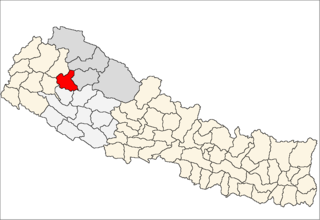
Pipalkot is a village in Bajhang District in the Seti Zone of north-western Nepal. At the time of the 1991 Nepal census it had a population of 3,296 and had 611 houses in the village.
Hariharpur is a town in Chhireswarnath Municipality in Dhanusa District in the Janakpur Zone of south-eastern Nepal. The formerly Village Development Committee was converted into municipality merging along with existing vedics Ramdaiya, Sakhuwa Mahendranagar, Hariharpur and Digambarpur on 18 May 2014. At the time of the 1991 Nepal census it had a population of 6,259 persons residing in 1133 individual households.
Mukhiyapatti Musharniya is a village development committee in Dhanusa District in the Janakpur Zone of south-eastern Nepal. At the time of the 1991 Nepal census it had a population of 4,621 persons living in 436 individual households.
Saya is a village and municipality in Humla District in the Karnali Zone of north-western Nepal. At the time of the 1991 Nepal census it had a population of 1422 persons living in 268 individual households.
Puwamajwa is a village and Village Development Committee in Ilam District in the Mechi Zone of eastern Nepal. At the time of the 1991 Nepal census it had a population of 2,419 persons living in 397 individual households.
Soyak is a town and Village Development Committee in Ilam District in the Mechi Zone of eastern Nepal. At the time of the 1991 Nepal census, it had a population of 2,758 living in 494 individual households.
Chapakot is a village and Village Development Committee in Kaski District in the Gandaki Zone of northern-central Nepal. At the time of the 1991 Nepal census it had a population of 2,966 persons residing in 574 individual households.
Toli is a village development committee in Dailekh District in the Bheri Zone of western-central Nepal. At the time of the 1991 Nepal census it had a population of 2493 people living in 399 individual households.
Sahare is a Village Development Committee in Surkhet District in the Bheri Zone of mid-western Nepal. At the time of the 1991 Nepal census it had a population of 7297 people residing in 1318 individual households.
Girichauka is a village development committee in Doti District in the Seti Zone of western Nepal. At the time of the 1991 Nepal census it had a population of 3320 living in 616 individual households.
Kadamandau is a village development committee in Doti District in the Seti Zone of western Nepal. At the time of the 1991 Nepal census it had a population of 3084 living in 609 individual households.
Khuttapipradhi is a village development committee in Mahottari District in the Janakpur Zone of south-eastern Nepal. At the time of the 1991 Nepal census it had a population of 7184 people living in 1387 individual households.
Pokhari is a Village Development Committee in Doti District in the Seti Zone of western Nepal. At the time of the 1991 Nepal census it had a population of 2968 residing in 632 individual households.

Sithdipur is a village development committee in Udayapur District in the Sagarmatha Zone of south-eastern Nepal. At the time of the 1991 Nepal census it had a population of 2606 people living in 459 individual households.
Ajingara is a village development committee in Kapilvastu District in the Lumbini Zone of southern Nepal. At the time of the 1991 Nepal census it had a population of 3646 people living in 603 individual households.


