Mount Kailash, is a 6,714 m (22,028 ft) high peak in the Kailash Range, which forms part of the Transhimalaya in the Ngari Prefecture, Tibet Autonomous Region of China, close to India and Nepal borders in the South.

Lake Manasarovar, also called mTsho Mapham or mTsho Ma-dros-pa locally;, is a high altitude freshwater lake fed by the Kailash Glaciers near Mount Kailash in Burang County, Ngari Prefecture, Tibet Autonomous Region, China. The lake along with Mount Kailash to its north are sacred sites in four religions: Bön, Buddhism, Hinduism and Jainism.

Lake Rakshastal is a saltwater lake in Tibet Autonomous Region, China, lying just west of Lake Manasarovar and south of Mount Kailash. The Sutlej River originates at Rakshastal's northwestern tip.

Langtang is a region in the north-central Himalayas of the Bagmati Province of Nepal. Situated 51 kilometres north of the Kathmandu Valley, the region is renowned for hosting the Langtang national park which eventually constitutes the border with the Tibet autonomous region of China. About 4,500 people reside inside the park, and many more depend on it for timber and firewood.

Humla District, a part of Karnali Province, is one of the seventy-seven districts of Nepal. The district, with Simikot as its district headquarters, covers an area of 5,655 km2 (2,183 sq mi) and has population of 50,858 as per the census of 2011. Namkha is the largest rural municipal which lies in humla Humla is the 2nd largest district of Nepal. The southern and middle parts of Humla District are inhabited by Khas communities, originating from Sinja valley, whereas the higher and northern parts of Humla are mostly inhabited by culturally Tibetan communities.

Gurla Mandhata, also Naimona'nyi or Nemo Nani, is the highest peak of the Nalakankar Himal, a small subrange of the Himalaya. It is named after king Mandhata of suryavansha of Ikshvaku dynasty. It lies in Burang County of the Ngari Prefecture in the Tibet Autonomous Region of China, near the northwest corner of Nepal. It is the 34th-highest peak in the world. It is also notable for being well within the interior of the Tibetan Plateau and relatively far away from other peaks with heights greater than 7,500 metres. It sits roughly across Lake Manasarovar from the sacred peak of Mount Kailash. The Tibetan name, Naimona'nyi, is said to come from naimo = "herbal medicine", na = "black", nyi = "heaped-up slabs", giving "the mountain of heaped-up slabs of black herbal medicine."
Nepalgunj, also spelled Nepalganj, is a Sub-Metropolitan City in Banke District, Nepal. It lies on the Terai plains near the southern border with Bahraich district in Uttar Pradesh, India. Nepalgunj is 153 kilometers south-west of Ghorahi and 16 km south of Kohalpur. Former Village Development Committee: Udayapur, Bhawaniyapur, Piprahawa, Jaispur, Paraspur, Indrapur, Khaskarkado, Bashudevpur, Manikapur and Puraina were added to territory in order to make it Sub metropolitan city on 2071 Paush 28 and later Puraini was also added in list on 2072 Paush 21. Further, while restructuring of local levels nationwide, ward no. 23 was taken out to Janaki Rural Municipality and ward no. 7 of Hirminiya VDC was added to Nepalgunj.

Burang County, also called Purang, is an administrative division of Ngari Prefecture in the Tibet Autonomous Region (TAR) of China. The county seat is Burang Town, known as Taklakot in Nepali. The county covers an area of 12,539 square kilometres (4,841 sq mi), and has a population of 9,657 as of 2010.
Lipulekh is a Himalayan pass on the border of India, Nepal and China. It is one of the routes for the pilgrimage to Mount Kailash and Mansarovar in Tibet, China. This territory was ceded to British India after the Anglo-Nepalese War in 1816 under the Sugauli treaty. In 2020, Nepal suddenly made a claim to this territory under the Prime Ministership of KP Sharma Oli understandably at the behest of the Chinese Ambassador to Nepal.
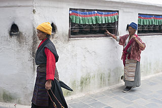
Kora is a transliteration of a Tibetan word that means "circumambulation" or "revolution". Kora is both a type of pilgrimage and a type of meditative practice in the Tibetan Buddhist or Bon traditions. A Kora is performed by the practitioner making a circumambulation around a sacred site or object, typically as a constituent part of a pilgrimage, ceremony, celebration or ritual. In broader terms, it is a term that is often used to refer to the entire pilgrimage experience in the Tibetan regions.

Simikot Airport is a domestic airport located in Simikot serving Humla District, a district in Karnali Province in Nepal. It is the main tourist gateway on the Nepalese side to the Mount Kailash and Lake Manasarovar. As road access in this area of Nepal is weak, the airport facilitates travel in the whole district of Humla.
Birendranagar officially Birendranagar Municipality is a city in Surkhet District in Karnali Province of Nepal. It is the District headquarter of Surkhet District and also the Capital city of Karnali province. As of March 2022, Birendranagar has a population of 154,886 making it the 17th largest city of Nepal. It is the largest city of karnali province and 7th largest in Western Nepal. It is one of the fastest growing cities of Nepal. Birendranagar is the destination of two national highways i.e Ratna Highway and Karnali Highway. It is one of the constituent city of Ratna Highway Metropolitan Areas along with Nepalgunj and Kohalpur. Birendranagar is compromise of beautiful panoramic view of Mahabharata and chure ranges and the plain of inner terai. Birendranagar is a major trade center in mid-western Nepal and is considered as the most expensive city to live in Nepal.

Burang, known as Purang in Tibetan, is a town which serves as the administrative center of Burang County, Ngari Prefecture of the Tibet Autonomous Region (TAR), China. The town lies at an altitude of 3,900m in the valley of the Karnali River. As of 2010, the town had a population of 6,047. To the south are Gurla Mandhata and the Abi Gamin ranges. Lake Manasarovar and Mount Kailash are to the north. This region is the mythological and actual river nexus of the Himalaya with sources of the Indus, Ganges and Yarlung Tsangpo/Brahmaputra all within 110 kilometres (70 mi) of Burang.
Kevin Bubriski is an American documentary photographer.

Limi Valley is a high-altitude valley that forms the northermost part of the Humla District of north-western Nepal. To its north, the Limi valley borders the Purang County of Tibet. Geographically, the valley is drained by the Limi river, a tributary of the Humla Karnali river.

Kangsa Village, poetically known as Darchen, Tarchan or Taqin, is a former Bhutanese enclave, currently held by the People's Republic of China and the seat of the Parga Township, Purang County, Tibet Autonomous Region, China. Thus, it is commonly referred as Parga although there is another smaller settlement formally named Parga after which the Parga Township was named, located on the east of this settlement. It was also previously known as Lhara and still signposted as such. It was previously an important sheep station for nomads and their flocks and had only two permanent buildings; only one of which survived the Cultural Revolution and is now used to house Tibetan pilgrims.
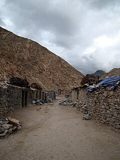
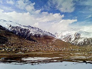
Hilsa is a village in the northwestern corner of Nepal bordering Tibet Autonomous Region (China), where the Humla Karnali crosses from the Tibetan Plateau into the mountain regions on its descent to the Ganges. Hilsa is in Humla District, Karnali Zone facing Burang County, Ngari the westernmost prefecture of the T.A.R.

Fishtail Air Pvt. Ltd., from 2018 to 2020 known as Summit Helicopters Pvt. Ltd., is a helicopter airline based at Tribhuvan International Airport in Kathmandu, Nepal, operating chartered helicopter services. The company was established in 1997 under the Air Operators Certificate issued by the Government of Nepal. The Company carries domestic chartered helicopter flights throughout Nepal out and Rescue Missions. It also carries out and also international chartered flights to Bhutan and India.

The China–Nepal border is the international boundary between the Tibet Autonomous Region of China and Nepal. It is 1,389 kilometres (863 mi) in length and runs in a northwest–southeast direction along the Himalayan mountain range, including Mount Everest, the world's highest mountain. The boundaries of this particular border have changed dramatically over time, especially when considering relatively recent events such as the Annexation of Tibet in 1949. However, some of the most significant developments of modern times would be the signing of the "Agreement on Maintaining Friendly Relations between the People’s Republic of China and the Kingdom of Nepal" in 1956 and the "Sino-Nepalese Treaty of Peace and Friendship" in 1960, both of which formally recognised Tibet as a part of China and confirmed the limits of the countries of China and Nepal as they are known today.
Nyalu Lagna Pass or just Nyalu Pass is a mountain pass on Himalayas at elevation of 4,995 metres (16,388 ft) above the sea level. The pass is located at Humla District of Karnali Province in Nepal. Limi-Lapcha Road crosses through this pass to connect the Limi valley with Simikot. Simikot is the district headquarter of Humla. This pass lies on an ancient trade route between Humla and Tibet, starting from Salli Khola in the Humla Karnali valley, going through Tsong Tsa valley, passing over the Nyalu Lagna pass, then going through the Talung valley, and entering the Limi valley near Takche. From Takche, one path heads west, to village Dzang, and the other path heads north, to the Lapcha La pass, further north beyond which lies the Purang County of the Tibetan Autonomous Region, China.