
East Lothian is one of the 32 council areas of Scotland, as well as a historic county, registration county and lieutenancy area. The county was called Haddingtonshire until 1921.

A coast guard or coastguard is a maritime security organization of a particular country. The term embraces wide range of responsibilities in different countries, from being a heavily armed military force with customs and security duties to being a volunteer organization tasked with search and rescue without law enforcement authority. In most countries, a typical coast guard's functions are distinct from those of the navy and the transit police, while in certain countries they have similarities to both.

Lamlash is a village on the Isle of Arran, in the Firth of Clyde, Scotland. It lies three miles south of the island's main settlement and ferry port Brodick, in a sheltered bay on the island's east coast, facing the Holy Isle. Lamlash is the seat of Arran's local government offices, and is also the location of the island's police station, secondary school and hospital. In common with the rest of the island, the village's main industry is tourism and the public sector is also an important employer. Lamlash has an RNLI Lifeboat station with a B class Atlantic 75 lifeboat, covering the inshore waters around the coast of Arran, and in summer, there is a regular ferry service from Lamlash harbour to Holy Isle. The village has several buildings of historical interest, including Hamilton Terrace, which consists of two rows of single storey-and-attic cottages on the Lamlash seafront, arranged in pairs.

Berwickshire is a historic county, registration county and lieutenancy area in south-eastern Scotland, on the English border. The county takes its name from Berwick-upon-Tweed, its original county town, which was part of Scotland at the time of the county's formation in the twelfth century, but became part of England in 1482 after several centuries of swapping back and forth between the two kingdoms. After the loss of Berwick, Duns and Greenlaw both served as county town at different periods.

Eyemouth is a small town and civil parish in Berwickshire, in the Scottish Borders area of Scotland. It is two miles east of the main north–south A1 road and eight miles north of Berwick-upon-Tweed.

The coble is a type of open traditional fishing boat which developed on the North East coast of England. The southernmost examples occur around Hull ; the type extends to Burnmouth just across the Scottish border.
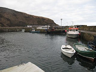
Burnmouth is a small fishing village located adjacent to the A1 road on the east coast of Scotland. It is the first village in Scotland on the A1, after crossing the border with England. Burnmouth is located in the Parish of Ayton, in the Scottish Borders area of Scotland and governed by Scottish Borders Council.
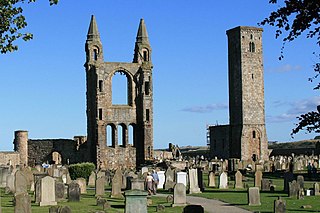
The Cathedral of St Andrew is a ruined cathedral in St Andrews, Fife, Scotland. It was built in 1158 and became the centre of the Medieval Catholic Church in Scotland as the seat of the Archdiocese of St Andrews and the Bishops and Archbishops of St Andrews. It fell into disuse and ruin after Catholic mass was outlawed during the 16th-century Scottish Reformation. It is currently a monument in the custody of Historic Environment Scotland. The ruins indicate that the building was approximately 119 m (390 ft) long, and is the largest church to have been built in Scotland.
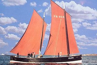
Reaper is a restored historic Fifie herring drifter which is registered by the National Historic Ships Committee as part of the National Historic Fleet of the UK, and currently operates as a museum ship.
The Scottish east coast fishery has been in existence for more than a thousand years, spanning the Viking Age right up to the present day.

William de Lamberton, sometimes modernized as William Lamberton, was Bishop of St Andrews from 1297 until his death. Lamberton is renowned for his influential role during the Scottish Wars of Independence. He campaigned for the national cause under William Wallace and later Robert the Bruce. As Bishop of St Andrews, the most powerful seat in Scotland, Bishop Lamberton along with Bishop Robert Wishart of Glasgow conducted the coronation of Robert the Bruce as King Robert I. Lamberton would go on to have a vital role in the formulation of the Declaration of the Clergy 1310 and the Declaration of Arbroath which would lead to Scottish Independence.
Lamberton is a hilly, former landed estate in Berwickshire, Scotland, its eastern boundary being the North Sea. It is 4 miles (6.4 km) north of Berwick-upon-Tweed, on the Great North Road.
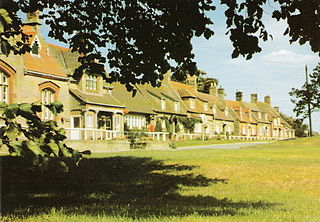
Foulden is a civil parish and village in the Berwickshire area of Scottish Borders, Scotland, situated not far above the Whiteadder Water, and 7 miles (11 km) west of Berwick-upon-Tweed.

Mordington is an agricultural parish in the extreme south-east of Berwickshire in the Scottish Borders region. It is five miles from Berwick-upon-Tweed and borders Northumberland to the east, and south, Foulden to the west, and Lamberton to the north. The parish is bisected by the A6105 Berwick to Duns road. The lower part of the parish is covered by the Edrington estate. It is possibly the warmest parish in Scotland; the annual hours of sunshine are said to be almost as high as at Dunbar, which records the most hours in Scotland.

The fishing industry in Scotland comprises a significant proportion of the United Kingdom fishing industry. A recent inquiry by the Royal Society of Edinburgh found fishing to be of much greater social, economic and cultural importance to Scotland than it is relative to the rest of the UK. Scotland has just 8.4 per cent of the UK population but lands at its ports over 60 per cent of the total catch in the UK.

The Anglo-Scottish border is a border separating Scotland and England which runs for 96 miles (154 km) between Marshall Meadows Bay on the east coast and the Solway Firth in the west.

A fishing village is a village, usually located near a fishing ground, with an economy based on catching fish and harvesting seafood. The continents and islands around the world have coastlines totalling around 356,000 kilometres (221,000 mi). From Neolithic times, these coastlines, as well as the shorelines of inland lakes and the banks of rivers, have been punctuated with fishing villages. Most surviving fishing villages are traditional.

Fishing in Cornwall, England, UK, has traditionally been one of the main elements of the economy of the county. Pilchard fishing and processing was a thriving industry in Cornwall from around 1750 to around 1880, after which it went into an almost terminal decline. During the 20th century the varieties of fish taken became much more diverse and crustaceans such as crab and lobster are now significant. Much of the catch is exported to France due to the higher prices obtainable there. Though fishing has been significantly damaged by overfishing, the Southwest Handline Fishermen's Association has started to revive the fishing industry. As of 2007, stocks were improving. The Cornwall Sea Fisheries Committee is one of 12 committees responsible for managing the corresponding Sea Fisheries District. The Isles of Scilly Sea Fisheries Committee is responsible for the Scilly district.

Edrom is a parish and small village in the pre-1975 ancient county of Berwickshire, now an administrative area of the Scottish Borders region of Scotland.
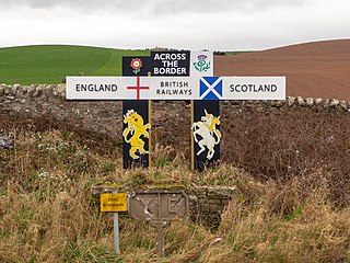
Marshall Meadows Bay is the northernmost point of England. It is located on the Northumberland coast, 2+1⁄2 miles north of Berwick-upon-Tweed, and just to the south of the Anglo-Scottish border. Across the border in Scotland is the county of Berwickshire in the Borders region. The hamlet of Marshall Meadows lies to the west of the bay, and is the most northerly inhabited place in England. The Marshall Meadows Manor House Hotel is here, along with a farm and a caravan site. There is a disused tunnel from the caravan site to the bay below, and there is a small cave 300 m (1,000 ft) north of this tunnel, plus another small cave just around the corner of Marshall Meadows Point. Nearby is the A1 trunk road and the East Coast Main Line railway.


