
The River Clyde is a river that flows into the Firth of Clyde, in the west of Scotland. It is the ninth-longest river in the United Kingdom, and the third longest in Scotland after the River Tay and the River Spey. It runs through the city of Glasgow. The River Clyde estuary has an upper tidal limit located at the tidal weir next to Glasgow Green.
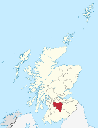
South Lanarkshire is one of 32 unitary authorities of Scotland. It borders the south-east of the Glasgow City council area and contains some of Greater Glasgow's suburban towns, as well as many rural towns and villages. It also shares borders with Dumfries and Galloway, East Ayrshire, East Renfrewshire, North Lanarkshire, the Scottish Borders and West Lothian. It includes most of the historic county of Lanarkshire.

North Lanarkshire is one of the 32 council areas of Scotland. It borders the north-east of the Glasgow City council area and contains many of Glasgow's suburbs, commuter towns, and villages. It also borders East Dunbartonshire, Falkirk, Stirling, South Lanarkshire, and West Lothian. The council area covers parts of the historic counties of Dunbartonshire, Lanarkshire, and Stirlingshire. The council is based in Motherwell.
Govan is a district, parish, and former burgh now part of southwest Glasgow, Scotland. It is situated 2+1⁄2 miles west of Glasgow city centre, on the south bank of the River Clyde, opposite the mouth of the River Kelvin and the district of Partick. Historically it was part of the County of Lanark.

Rutherglen is a town in South Lanarkshire, Scotland, immediately south-east of the city of Glasgow, three miles from its centre and directly south of the River Clyde. Having previously existed as a separate Lanarkshire burgh, in 1975 Rutherglen lost its own local council and administratively became a component of the City of Glasgow District within the Strathclyde region. In 1996 the towns were reallocated to the South Lanarkshire council area.

Lanark is a town in South Lanarkshire, Scotland, located 20 kilometres to the south-east of Hamilton. The town lies on the River Clyde, at its confluence with Mouse Water. In 2016, the town had a population of 9,050.

East Kilbride is the largest town in South Lanarkshire in Scotland, and the country's sixth-largest locality by population. It was also designated Scotland's first new town on 6 May 1947. The area lies on a raised plateau to the south of the Cathkin Braes, about eight miles southeast of Glasgow and close to the boundary with East Renfrewshire.

Irvine is a town and former royal burgh on the coast of the Firth of Clyde in North Ayrshire, Scotland. The 2011 Census recorded the town's population at 33,698 inhabitants, making it the largest settlement in North Ayrshire, and 22nd largest settlement in Scotland. Irvine was designated at the fifth and final Scottish new town in November 1966. Irvine is the administrative centre and the seat of the North Ayrshire Council administration which has its headquarters based at Cunninghame House. Irvine was the site of Scotland's 12th century military capital and former headquarters of the Lord High Constable of Scotland, Hugh de Morville. It also served as the capital of Cunninghame and was, at the time of David I, Robert II and Robert III, one of the earliest capitals of Scotland.

Motherwell is a town and former burgh in North Lanarkshire, Scotland, United Kingdom, south east of Glasgow. It has a population of around 32,120. Historically in the parish of Dalziel and part of Lanarkshire, Motherwell is the headquarters for North Lanarkshire Council. Geographically the River Clyde separates Motherwell from Hamilton to the west whereas the South Calder Water separates Motherwell from Carfin to the north-east and New Stevenston and Bellshill towards the north.

A royal burgh was a type of Scottish burgh which had been founded by, or subsequently granted, a royal charter. Although abolished by law in 1975, the term is still used by many former royal burghs.

Dumbarton is a town in West Dunbartonshire, Scotland, on the north bank of the River Clyde where the River Leven flows into the Clyde estuary. In 2006, it had an estimated population of 19,990.

Port Glasgow is the second-largest town in the Inverclyde council area of Scotland. The population according to the 1991 census for Port Glasgow was 19,426 persons and in the 2001 census was 16,617 persons. The most recent census in 2011 states that the population has declined to 15,414. It is located immediately to the east of Greenock and was previously a burgh in the county of Renfrewshire.

Biggar is a town, parish and former burgh in South Lanarkshire, Scotland, in the Southern Uplands near the River Clyde on the A702. The closest neighbouring towns are Lanark, Peebles and Carluke.

Renfrewshire or the County of Renfrew is a historic county, registration county and lieutenancy area in the west central Lowlands of Scotland. The lieutenancy area covers the three modern council areas of Inverclyde, Renfrewshire and East Renfrewshire, and this area is occasionally termed Greater Renfrewshire to distinguish it from the modern council area called Renfrewshire. The historic county additionally included territory on the south-western edge of Glasgow which was gradually transferred to the administrative area of the city as it grew.

The Antonine Wall was a turf fortification on stone foundations, built by the Romans across what is now the Central Belt of Scotland, between the Firth of Clyde and the Firth of Forth. Built some twenty years after Hadrian's Wall to the south, and intended to supersede it, while it was garrisoned it was the northernmost frontier barrier of the Roman Empire. It spanned approximately 63 kilometres and was about 3 metres high and 5 metres wide. Lidar scans have been carried out to establish the length of the wall and the Roman distance units used. Security was bolstered by a deep ditch on the northern side. It is thought that there was a wooden palisade on top of the turf. The barrier was the second of two "great walls" created by the Romans in Great Britain in the second century AD. Its ruins are less evident than those of the better-known and longer Hadrian's Wall to the south, primarily because the turf and wood wall has largely weathered away, unlike its stone-built southern predecessor.
Partick Castle was located in Partick, now a Western suburb of Glasgow. It was built in 1611 for the Glasgow benefactor George Hutcheson and situated on the west bank of the River Kelvin.
The architecture of Scotland includes all human building within the modern borders of Scotland, from the Neolithic era to the present day. The earliest surviving houses go back around 9500 years, and the first villages 6000 years: Skara Brae on the Mainland of Orkney being the earliest preserved example in Europe. Crannogs, roundhouses, each built on an artificial island, date from the Bronze Age and stone buildings called Atlantic roundhouses and larger earthwork hill forts from the Iron Age. The arrival of the Romans from about 71 AD led to the creation of forts like that at Trimontium, and a continuous fortification between the Firth of Forth and the Firth of Clyde known as the Antonine Wall, built in the second century AD. Beyond Roman influence, there is evidence of wheelhouses and underground souterrains. After the departure of the Romans there were a series of nucleated hill forts, often utilising major geographical features, as at Dunadd and Dunbarton.

Renfrew is a town 6 miles (10 km) west of Glasgow in the west central Lowlands of Scotland. It is the historic county town of Renfrewshire. Called the "Cradle of the Royal Stewarts" for its early link with Scotland's former royal house, Renfrew gained royal burgh status in 1397.

Burgh Castle is the site of one of nine Roman Saxon Shore forts constructed in England around the 3rd century AD, to hold troops as a defence against Saxon raids up the rivers of the east and south coasts of southern Britain. It is located on the summit of ground sloping steeply towards the estuary of the River Waveney, in the civil parish of Burgh Castle, in the county of Norfolk.

The architecture of Scotland in the Roman era includes all building within the modern borders of Scotland, from the arrival of the Romans in northern Britain in the first century BCE, until their departure in the fifth century CE. Ptolemy indicated that there were 19 "towns" in Caledonia, north of the Roman province of Britannia, but no clear evidence of urban settlements has been found and these were probably hillforts. There is evidence of over 1,000 such forts, most south of the Clyde-Forth line, but the majority seem to have been abandoned in the Roman period. There is also evidence of distinctive stone wheelhouses and small underground souterrains.
