Related Research Articles

Assam is a state in northeastern India, south of the eastern Himalayas along the Brahmaputra and Barak River valleys. Assam covers an area of 78,438 km2 (30,285 sq mi). The state is bordered by Bhutan and Arunachal Pradesh to the north; Nagaland and Manipur to the east; Meghalaya, Tripura, Mizoram and Bangladesh to the south; and West Bengal to the west via the Siliguri Corridor, a 22 kilometres (14 mi) wide strip of land that connects the state to the rest of India. Assamese and Boro are the official languages of Assam, while Bengali is an additional official language in the Barak Valley.

Mizoram is a state in Northeast India, with Aizawl as its seat of government and capital city. The name of the state is derived from "Mizo", the self-described name of the native inhabitants, and "Ram", which in the Mizo language means "land." Thus "Mizo-ram" means "land of the Mizos". Within India's northeast region, it is the southernmost landlocked state, sharing borders with three of the Seven Sister States, namely Tripura, Assam and Manipur. The state also shares a 722-kilometre (449 mi) border with the neighbouring countries of Bangladesh and Myanmar.

Northeast India (officially the North Eastern Region(NER)) is the easternmost region of India representing both a geographic and political administrative division of the country. It comprises eight states—Arunachal Pradesh, Assam, Manipur, Meghalaya, Mizoram, Nagaland and Tripura (commonly known as the "Seven Sisters"), and the "brother" state Sikkim.
The Assam Rifles (AR) is a central paramilitary force responsible for border security, counter-insurgency, and maintaining law and order in Northeast India. It guards the Indo-Myanmar border. The AR is one among the Central Armed Police Forces (CAPF) of India and comes under the administration of the Ministry of Home Affairs, while its operational control is maintained by the Indian Army. Being a police force, its recruitment, perks, promotions, and retirement policies are governed by CAPF rules. Around 80 percent of its officers are deputed from the Indian Army and remaining from AR cadre. The AR is commanded by the Director General of the Assam Rifles who is appointed by the Ministry of Home Affairs.

The Mizo National Front is a regional political party in Mizoram, India. MNF emerged from the Mizo National Famine Front, which was formed by Pu Laldenga to protest against the inaction of the Government of India towards the famine situation in the Mizo areas of the Assam state in 1959. It staged a major uprising in 1966, followed by years of underground activities. In 1986, it signed the Mizoram Accord with the Government of India, renouncing secession and violence. The MNF then began contesting elections and has formed state government in Mizoram three times. It is currently the state's ruling party, with its president, Zoramthanga, as the Chief Minister of Mizoram.

The Insurgency in Northeast India involves multiple armed separatist factions operating in some of India's northeastern states, which are connected to the rest of India by the Siliguri Corridor, a strip of land as narrow as 14.29 miles (23.00 km) wide.
The Gauhati High Court was promulgated by governor general of India on 1 March 1948 after the Government of India Act 1935 was passed. Establishing the High Court of Assam with effect from 5 April 1948, for the then Province of Assam. It was originally known as the High Court of Assam and Nagaland, but renamed as Gauhati High Court in 1971 by the North-Eastern Areas (Reorganisation) Act, 1971.

Lengpui Airport is a domestic airport in Lengpui, serving Aizawl, the capital of Mizoram, India. The airport is connected by flights to Kolkata, Guwahati and Imphal, and is located at a distance of 32 km from Aizawl. Lengpui Airport is the first airport in the country to be built by the Government of Mizoram.

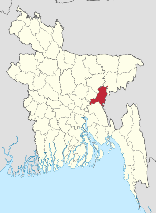
The Barak Valley is located in the southern region of the Indian state of Assam. The region is named after the Barak river. The Barak valley consists of three administrative districts of Assam - namely Cachar, Karimganj, and Hailakandi. The main, largest and capital city of the Valley is Silchar. Once North Cachar Hills was a part of the valley but In 1951 erstwhile Sub-Division was made a separate district and eventually curved out of Cachar. On 1 July 1983, Karimganj district was curved out from the eponymous subdivision of Cachar Valley. This was again repeated in 1989 with the creation of Hailakandi district.

The Bangladesh–India border, known locally as the Radcliffe line (IB), is an international border running between Bangladesh and India that demarcates the eight divisions of Bangladesh and the Indian states.
Secession in India typically refers to state secession, which is the withdrawal of one or more states from the Republic of India. Whereas, some have wanted a separate state, union territory or an autonomous administrative division within India. Many separatist movements exist with thousands of members, however, some have low local support and high voter participation in democratic elections. However, at the same time, demanding separate statehood within under the administration of Indian union from an existing state can lead to criminal charges under secession law in India. India is described as a ‘Union of States’ in Article 1 of the Indian constitution I.e indestructible nation of destructible states where a state or Union territory of India can't secede from India by any means.
Human rights issues in northeast India have been widely reported in the press and by human rights activists. Northeast India refers to the easternmost region of India consisting of the states of Arunachal Pradesh, Assam, Manipur, Meghalaya, Mizoram, Nagaland, Sikkim, and Tripura, as well as parts of northern West Bengal.

Dr. Himanta Biswa Sarma is an Indian politician serving as the 15th and incumbent Chief Minister of Assam since 2021. A former member of the Indian National Congress political party. Sarma joined the Bharatiya Janata Party on 23 August 2015. He is a five time Member of the Assam Legislative Assembly from Jalukbari, having been elected in 2001.He also served as Minister in the Government of Assam.

National Highway 2 is a national highway in India that runs from Dibrugarh in Assam to Tuipang in Mizoram. This national highway passes through the Indian states of Assam, Nagaland, Manipur and Mizoram. This national highway is 1,325.6 km (823.7 mi) long. Before renumbering of national highways, NH-2 was variously numbered as old national highways 37, 61, 39, 150 and 54.
The Republic of India shares borders with several sovereign countries; it shares land borders with China, Bhutan, Nepal, Pakistan, Afghanistan, Bangladesh and Myanmar. Bangladesh and Pakistan share both land borders as well as maritime borders, while Sri Lanka shares only a maritime border through Ram Setu. India's Andaman and Nicobar Islands share a maritime border with Thailand, Myanmar and Indonesia.
The Port of Ashuganj is a notable river port in eastern Bangladesh. It is one of the important industrial ports of the Bengal delta. It is located on the Meghna River. The port is a regional transshipment center in Eastern South Asia.
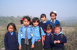
The hill tribes of Northeast India are hill people, mostly classified as Scheduled Tribes (STs), who live in the Northeast India region. This region has the largest proportion of scheduled tribes in the country.
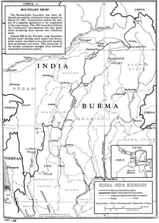
The India–Myanmar border is the international border between India and Myanmar. The border is 1,643 kilometres (1,021 mi) in length and runs from the tripoint with China in the north to the tripoint with Bangladesh in the south.
Border disputes of Northeast India mainly include inter-state conflict between Assam–Mizoram, Assam–Arunachal Pradesh, Assam–Nagaland and Assam–Meghalaya. The disputes, including clashes between rival police forces, have resulted in the loss of life, livelihood and property. The border disputes in some cases are part of the larger national (separatist), sub-regional and ethnic conflicts, as well as criminal enterprise fuelled. This internal land conflict in the districts of the northeast are part of the 322 districts affected by ongoing land conflicts out of a total of 703 districts in India.
References
- 1 2 Worsdell, T; Shrivastava, K (2020). "Locating the Breach: Mapping the nature of land conflicts in India" (PDF). Land Conflict Watch. New Delhi: Nut Graph LLP, Rights and Resources Initiative, and Oxfam India. Archived (PDF) from the original on 15 February 2021. Retrieved 29 July 2021.
- ↑ Wahi, Namita (26 June 2019). "Understanding Land Conflict in India and Suggestions for Reform". cprindia.org. Centre for Policy Research. Retrieved 2021-07-29.
- ↑ Kalita, Prabin (23 August 2014). "Unhappy with boundaries, NE sisters nibbling away at our land, Gogoi says". The Times of India. Retrieved 2021-07-28.
- ↑ Deb, Debraj (2021-07-28). "Explained: How did the 150-year-old Assam-Mizoram dispute get so violent now?". The Indian Express. Retrieved 2021-07-28.
| | This India-related article is a stub. You can help Wikipedia by expanding it. |