
The Euphrates is the longest and one of the most historically important rivers of Western Asia. Together with the Tigris, it is one of the two defining rivers of Mesopotamia. Originating in the Armenian Highlands of eastern Turkey, the Euphrates flows through Syria and Iraq to join the Tigris in the Shatt al-Arab, which empties into the Persian Gulf.

The Fertile Crescent is a crescent-shaped region in the Middle East, spanning modern-day Iraq, Syria, Lebanon, Israel, Palestine, Jordan, Egypt, together with the southeastern region of Turkey and the western fringes of Iran. Some authors also include Cyprus.

The Tigris–Euphrates river system is a large river system in Western Asia which discharges into the Persian Gulf. Its principal rivers are the Tigris and Euphrates along with smaller tributaries.

The Southern Levant is a geographical region encompassing the southern half of the Levant. It corresponds approximately to modern-day Israel, Palestine, and Jordan; some definitions also include southern Lebanon, southern Syria and/or the Sinai Peninsula. As a strictly geographical description, it is sometimes used by archaeologists and historians to avoid the religious and political connotations of other names for the area.
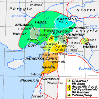
Carchemish, also spelled Karkemish was an important ancient capital in the northern part of the region of Syria. At times during its history the city was independent, but it was also part of the Mitanni, Hittite and Neo-Assyrian Empires. Today it is on the frontier between Turkey and Syria.

Near Eastern archaeology is a regional branch of the wider, global discipline of archaeology. It refers generally to the excavation and study of artifacts and material culture of the Near East from antiquity to the recent past.
The Balikh River is a perennial river that originates in the spring of Ain al-Arous near Tell Abyad in the Eastern Mediterranean conifer-sclerophyllous-broadleaf forests ecoregion. It flows due south and joins the Euphrates at the modern city of Raqqa. The Balikh is the second largest tributary to the Euphrates in Syria, after the Khabur River. It is an important source of water and large sections have recently been subjected to canalization.

The Keban Dam is a hydroelectric dam on the Euphrates, located in the Elazığ Province of Turkey. The dam was the first and uppermost of several large-scale dams to be built on the Euphrates by Turkey. Although the Keban Dam was not originally constructed as a part of the Southeastern Anatolia Project (GAP), it is now a fully integrated component of the project, which aims to stimulate economic development in Southeastern Turkey. Construction of the dam commenced in 1966 and was completed in 1974. Keban Dam Lake, the reservoir created by Keban Dam, has a surface area of 675 square kilometres (261 sq mi) and is reputedly the fourth-largest lake in Turkey after Lake Van, Lake Tuz, and the reservoir created by the Atatürk Dam.

Karkamış, aka Kargamış is a town and district of Gaziantep Province in southeastern Turkey, next to the site of ancient Karkemish. The population of the town was 2,998 in 2010.

Aleppo Governorate is one of the fourteen governorates of Syria. It is the most populous governorate in Syria with a population of more than 4,867,000, almost 23% of the total population of Syria. The governorate is the fifth in area with an area of 18,482 km2 (7,136 sq mi), or 18,498 sq. km, about 10% of the total area of Syria. The capital is the city of Aleppo.

Tell es-Sweyhat is the name of a large archaeological site on the Euphrates River in northern Syria. It is located in Raqqa Governorate roughly 95 km northeast of Aleppo and 60 km south of Carchemish. Also, an Uruk site of Jebel Aruda is located just across the river.

The ancient Near East was the home of early civilizations within a region roughly corresponding to the modern Middle East: Mesopotamia, ancient Egypt, ancient Iran, Anatolia/Asia Minor and the Armenian Highlands, the Levant, Cyprus and the Arabian Peninsula. The ancient Near East is studied in the fields of Ancient Near East studies, Near Eastern archaeology and ancient history.

The Nachcharini cave is located at a height of 2,100 m (6,889.76 ft) on the Nachcharini Plateau in the Anti-Lebanon mountains near the Lebanese/Syrian border and among the most elevated Natufian and Khiamian hunter-gatherer occupation sites found to date.
Urshu, Warsuwa or Urshum was a Hurrian-Amorite city-state in southern Turkey, probably located on the west bank of the Euphrates, and north of Carchemish.
Hassum was a Hurrian city-state, located in southern Turkey most probably on the Euphrates river north of Carchemish.

The Birecik Dam Cemetery is an Early Bronze Age cemetery in the Gaziantep region in southeastern Turkey. This cemetery was used extensively for a very short period of time at the beginning of the third millennium BC.
Tony James Wilkinson, FBA was a British archaeologist and academic, specialising in landscape archaeology and the Ancient Near East. He was Professor of Archaeology at the University of Edinburgh from 2005 to 2006, and Professor of Archaeology at Durham University from 2006 to until his death in 2014.
Jerablus Tahtani is a small tell near Carchemish in present-day Syria, which was occupied from the Chalcolithic period through the Early Bronze Age. Then, after a hiatus, it was occupied from the Iron Age through the Islamic period. It was excavated from 1991 to 2000 by the British as part of the Syrian government's Tishreen Dam rescue project. As of 2000 the site was still not underwater. This project successively developed into the Land of Carchemish project.

The Euphrates Syrian Pillar Figurines (EU_SPF's) are anthropomorphic clay figurines dating from the late Iron Age period and produced in the Middle Euphrates region. These figurines are part of a greater coroplastic production mainly composed of handmade horse-rider figurines, i.e. the Euphrates Handmade Syrian Horses and Riders (EU_HSHR's).
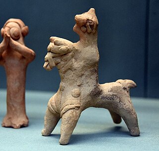
The Euphrates Handmade Syrian Horses and Riders are zoomorphic clay figurines representing both solely horses or horses provided with riders and dating from the late Iron Age period. These figurines are produced in the Middle Euphrates region and they belong to a production comprehending some anthropomorphic specimens, i.e. the Euphrates Syrian Pillar Figurines (EU_SPF's).