
Hunter Army Airfield, located in Savannah, Georgia, United States, is a military airfield and subordinate installation to Fort Stewart located in Hinesville, Georgia.

Plum Island Airport, in Newbury, Massachusetts, is a privately owned, public-use airport owned by Historic New England and operated by Plum Island Aerodrome, Inc., a non-profit corporation. It has two runways, averages 54 flights per week, and has approximately 8 based aircraft.

Willows-Glenn County Airport is a county-owned, public-use airport located one nautical mile (2 km) west of the central business district of Willows, a city in Glenn County, California, United States. This airport is included in the National Plan of Integrated Airport Systems for 2011–2015, which categorized it as a general aviation facility. It is also known as Willows-Glenn Airport.
Marine Corps Outlying Field (MCOLF) Camp Davis is a military use airport northeast of the central business district of Holly Ridge, in Onslow County, North Carolina, United States. It is used as a training facility by the United States Marines of Camp Lejeune and Marine Corps Air Station New River.

Lawson Army Airfield is a military airport located at Fort Moore in Chattahoochee County, Georgia, south of the city of Columbus, Georgia. It is Fort Moore's primary force projection platform.
Christchurch Airfield was located southeast of the A337/B3059 intersection in Somerford, Christchurch, Dorset, England.

Daniel Field is a public use airport located one nautical mile (2 km) west of the central business district of Augusta, a city in Richmond County, Georgia, United States. It is owned by the City of Augusta and operated by the General Aviation Commission. This airport is included in the National Plan of Integrated Airport Systems for 2021–2025, which categorized it as a general aviation facility.

Michael Army Airfield (MAAF) is a military airport located at the Dugway Proving Ground and owned by the United States Army. It is 9 miles (14 km) west of the proving grounds barracks at Dugway, Tooele County, Utah, United States.
During World War II, the United States Army Air Forces (USAAF) established numerous airfields in California for training pilots and aircrews of USAAF fighters and bombers.

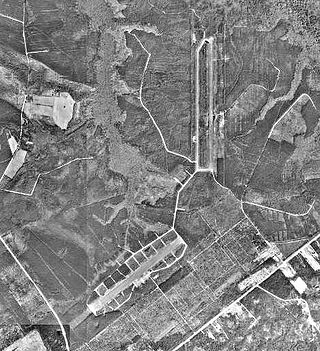
Harris Neck Army Airfield is an abandoned military airfield located in what is now the Harris Neck National Wildlife Refuge, McIntosh County, Georgia. It is located north of the intersection of Route 131 and Harris Neck Airport Road, about 30 miles (48 km) southwest of Savannah, Georgia.
Lowcountry Regional Airport is a public use airport located two nautical miles (4 km) northeast of the central business district of Walterboro, a city in Colleton County, South Carolina, United States. It is owned by the city and county. This airport is included in the National Plan of Integrated Airport Systems for 2011–2015, which categorized it as a general aviation facility. It does not have scheduled commercial airline service.

Charleston Executive Airport is in Charleston in Charleston County, South Carolina, seven miles southwest of the city. It is owned by the Charleston County Aviation Authority. The airport serves the general aviation community, with no airline service.

Saint-Simon – Clastres Air Base is an abandoned military airfield, which is located approximately 3 km (2 NM) northwest of Clastres and east of Saint-Simon, both communes in the Aisne department of the Picardy (Picardie) region in France. It is approximately 116 km (63 NM) north-northeast of Paris.

Cambrai-Niergnies Airport is a regional airport in France, located 3 miles (4.8 km) south-southeast of Cambrai; 100 miles (160 km) north-northeast of Paris.
Canton Island Airport is an airport located on Canton Island, a sparsely populated island in the Phoenix Islands of the Republic of Kiribati. It has a single asphalt runway measuring 6,230 feet (1,900 m) in length. Once a major stop on commercial trans-Pacific airline routes, today the airport is available for emergency use only.

Royal Air Force Harlaxton or more simply RAF Harlaxton is a former Royal Air Force satellite station near the village of Harlaxton, 3 mi (4.8 km) south west of Grantham, Lincolnshire, England. The airfield was located in a triangle of flat fields midway between Harlaxton Manor and the nearby village of Stroxton.

Columbus Municipal Airport is an abandoned airport in New Mexico. Its origins date to 1916 when it was used by the Aviation Section, U.S. Signal Corps as a military airfield during the Pancho Villa Expedition. It was apparently closed and abandoned in the late 1970s. Today, efforts are being made to restore it to a general aviation airport.
Chico Army Airfield auxiliary fields were a number of airfields used during World War II to support the Chico Army Airfield. On September 11, 1941, the US Army rented from the City of Chico a small 1930's airport that sat on 160 acres (0.65 km2) of land. The Airfield was five miles (8.0 km) north of the city center. The Army built up the small airport into the Chico Army Airfield. From the Chico Army Airfield operated the: United States Army Air Corps's Army Air Forces Basic Flying School, the Army Air Force Pilot School, the 10th Base Headquarters an Air Base Squadron and the 433rd Army Air Force Base Unit or Combat Crew Training Station of Fighter. To support the training of the many pilots, Chico Army Airfield operated a number of auxiliary airfields. Some auxiliary fields were no more than a landing strip runway, others were other operation airfield that supported the training at the Chico Army Airfield.

Victorville Army Airfield auxiliary fields were four airfields used during World War II to support the Victorville Army Airfield pilot training near Victorville, California, and Adelanto, California. After the war the Victorville Army Airfield was renamed George Air Force Base on January 13, 1948. The airfields were built in 1941 by the United States Army Air Corps just before the war. Victorville Army Airfield covered 2,200-acre in the Mojave Desert. The US Army held a groundbreaking ceremony on 12 July 1941. The base, called Victorville Army Flying School, was ready to use before the attack on Pearl Harbor on December 7, 1941. The Army built four runways in a triangle configuration, with one runway down the middle of the triangle. Seven hangars were built to support operation. On April 23, 1943, the base was renamed Victorville Army Airfield.

Merced Army Air Field auxiliary fields were built to support pilot training at the Merced Army Air Field. In 1940 the US Army wanted to build near Merced, California a 30,000 per year basic pilot training base. The former city of Cuba, Merced County, California near the Atchison, Topeka and Santa Fe Railway rail line was chosen at 37°22′50″N120°34′05″W at an elevation of 181 feet (55 m) for the main base, in Atwater, California. United States Army Air Corps leased the land from the City of Merced on 16 June 1941. Building the airbase school started on 8 July 1941 and opened on 20 September 1941 as a sub-base of Army Air Forces Western Flying Training Command at Moffett Field. First called Air Corps Basic Flying School, Merced. The US Army moved part of the: 98th Bombardment Group, 539th School Squadrons, 540th School Squadrons, 541st School Squadrons, the 90th Air Base Squadron, and the 340th Material Squadron at Moffett Field to the new base in November 1941. The Air Corps Basic Flying School was renamed the Merced Army Flying School on 7 April 1942. To support the training auxiliary fields near the Merced Army Flying School were to be built for the flight training program. Merced Army Flying School was renamed the Merced Army Air Field in May 1943 and became part of the Western Flying Training Command.


