
Brownsville is a borough in Fayette County, Pennsylvania, United States, first settled in 1785 as the site of a trading post a few years after the defeat of the Iroquois enabled a resumption of westward migration after the Revolutionary War. The trading post soon became a tavern and inn and was receiving emigrants heading west, as it was located above the cut bank overlooking the first ford that could be reached to those descending from the Allegheny Mountains. Brownsville is located 40 miles (64 km) south of Pittsburgh along the east bank of the Monongahela River.

West Brownsville is a former important transportation nexus and a present-day borough in Washington County, Pennsylvania, United States and part of the Pittsburgh metropolitan area. The population was 972 at the 2020 census. Culturally, by postal route, and socially, the community is connected to cross-river sister-city Brownsville. The two towns were long joined by the Amerindian trail known as Nemacolin's Path that became a wagon road after the American Revolution. In present times, however, West Brownsville is a separate municipality. Brownsville was the first point where the descent from the Appalachians could safely reach the river down the generally steep banks of the Monongahela River. Between Brownsville and West Brownsville was a shallow stretch, usable as a river ford astride a major Emigrant Trail to the various attractive regions in the Northwest Territory, the first National Road, the Cumberland Pike.

The Monongahela Railway was a coal-hauling Class II railroad in Pennsylvania and West Virginia in the United States. It was jointly controlled originally by the Pennsylvania Railroad, New York Central subsidiary Pittsburgh and Lake Erie Railroad, and the Baltimore and Ohio Railroad, with NYC and PRR later succeeded by Penn Central Transportation. The company operated its own line until it was merged into Conrail on May 1, 1993.
Redstone Old Fort — written as Redstone or Red-Stone Fort or Fort Burd — on the Nemacolin Trail, was the name of the French and Indian War-era wooden fort built in 1759 by Pennsylvania militia colonel James Burd to guard the ancient Indian trail's river ford on a mound overlooking the eastern shore of the Monongahela River in what is now Fayette County, Pennsylvania, near, or on the banks of Dunlap's Creek at the confluence. The site is unlikely to be the same as an earlier fort the French document as Hangard dated to 1754 and which was confusedly, likely located on the nearby stream called Redstone Creek. Red sandstones predominate the deposited rock column of the entire region.

The Smithfield Street Bridge is a lenticular truss bridge crossing the Monongahela River in Pittsburgh, Pennsylvania, USA.

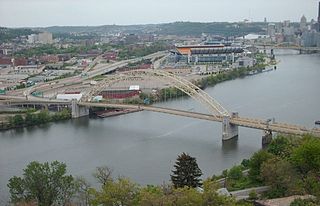
The Fort Pitt Bridge is a steel, double-decked bowstring arch bridge that spans the Monongahela River near its confluence with the Allegheny River in Pittsburgh, Pennsylvania. It carries Interstate 376 between the Fort Pitt Tunnel and Downtown Pittsburgh. Opened in June 1959 as a replacement for the Point Bridge, the Fort Pitt Bridge was the world's first computer-designed bowstring arch bridge and double-decked bowstring arch bridge. The bridge is known for its difficult lane changes, especially on the lower level, often requiring people to go from the extreme left lane across two lanes to the extreme right lane in only 700 feet. The upper level is more forgiving for some routes but still requires a full span lane change in 700 feet to get from the south side entrance to the downtown exits.
The Mon–Fayette Expressway is a partially-completed controlled-access toll road that is planned to eventually link Interstate 68 near Morgantown, West Virginia with Interstate 376 near Monroeville, Pennsylvania. The ultimate goal of the highway is to provide a high speed north–south connection between Morgantown and the eastern side of Pittsburgh while revitalizing economically distressed Monongahela River Valley towns in Fayette and Washington counties, serving as an alternative to Interstate 79 to the west, as well as relieving the PA 51 alignment from Pittsburgh to Uniontown.

The Panhandle Bridge carries the three lines of the Port Authority Light Rail Network across the Monongahela River in Pittsburgh, Pennsylvania. The name comes from Pennsylvania Railroad subsidiary Pittsburgh, Cincinnati, Chicago and St. Louis Railroad, also known as the Panhandle Route, which operated over the bridge.
The West End Bridge is a steel tied-arch bridge over the Ohio River in Pittsburgh, Pennsylvania, approximately 1 mile (1.6 km) below the confluence of the Allegheny and Monongahela Rivers. It connects the West End to the Chateau neighborhood on the North Side of Pittsburgh.

A large metropolitan area that is surrounded by rivers and hills, Pittsburgh has an infrastructure system that has been built out over the years to include roads, tunnels, bridges, railroads, inclines, bike paths, and stairways; however, the hills and rivers still form many barriers to transportation within the city.
Pennsylvania Route 88 is a 68-mile-long (109 km) north–south state highway located in southwestern Pennsylvania. The southern terminus of the route is at U.S. Route 119 (US 119) in Point Marion less than 2 miles (3 km) from the Pennsylvania-West Virginia border. The northern terminus is at PA 51 in Pittsburgh. PA 88 runs parallel to the Monongahela River for almost its entire length.
Pennsylvania Route 136 is a 40-mile-long (64 km) state highway located in Washington, Allegheny, and Westmoreland counties in Pennsylvania. The western terminus is at US 40 and PA 18 in Washington. The eastern terminus is at US 30 in Greensburg.
Pennsylvania Route 906 is a 10.6-mile-long (17.1 km) state highway located in Fayette, Westmoreland, and Allegheny counties in Pennsylvania. The southern terminus is at PA 201 in Washington Township. The northern terminus is at PA 136 in Forward Township.

U.S. Route 40 enters Pennsylvania at West Alexander. It closely parallels Interstate 70 (I-70) from West Virginia until it reaches Washington, where it follows Jefferson Avenue and Maiden Street. In Washington, US 40 passes to the south of Washington & Jefferson College. Following Maiden Street out of town, the road turns southeast toward the town of California. A short, limited-access highway in California and West Brownsville provides an approach to the Lane Bane Bridge across the Monongahela River. From here, the road continues southeast to Uniontown.
The Pittsburgh, Virginia and Charleston Railway was a predecessor of the Pennsylvania Railroad in the U.S. state of Pennsylvania. By 1905, when it was merged into the Pennsylvania, it owned a main line along the left (west) side of the Monongahela River, to Pittsburgh's South Side from West Brownsville. Branches connected to the South-West Pennsylvania Railway in Uniontown via Redstone Creek and to numerous coal mines.

The West Brownsville Junction Bridge carries the Norfolk Southern Railway across the Monongahela River from Brownsville Township to West Brownsville in the state of Pennsylvania. The main span is a 401-foot (122 m) Pennsylvania (Petit) truss. The structure was originally designed by the Pennsylvania Railroad as a low-level connector between its mainline and Waynesburg Branch. Today, the bridge continues to serve the same purpose that it has since its inception, carrying coal trains between mines and power plants or other industrial sites.

The Brownsville Bridge, also known as the Intercounty Bridge and the West Brownsville Bridge, is a truss bridge that carries vehicular traffic across the Monongahela River between Brownsville, Pennsylvania and West Brownsville, Pennsylvania. Since the opening of the Lane Bane Bridge and highway project to carry much of the intercounty through traffic away from the main streets of downtown Brownsville in the early 1960s, another commonly heard name is Old Brownsville Bridge for the four high level viaduct.
Blainsburg is an unincorporated community in Washington County, Pennsylvania, United States. Blainsburg is an outlier community of West Brownsville, Pennsylvania – a hamlet-sized neighborhood with more housing acreage than West Brownsville proper. Named after James G. Blaine, Blainsburg is part of the California Area School District. West Brownsville students attend Brownsville Area School District in Fayette County. The bedroom community is situated on the bluff above and slightly north-northwest of West Brownsville on the river bottom below. Blainsburg is located alongside and above the PA Route 88 climb from the W. Brownsville river flats which bends right, entering a shelf where it connects with the northwest streets of Blainsburg before taking a second ascent towards California. The parent and child communities are on the inside curve of a great meander in the Monongahela River in Southwestern Pennsylvania creating a degraded cut bank turned ramp and terrace on the opposite shore where Brownsville is situated. Blainsburg is often misspelled with an "E" in it, to match the spelling of its namesake, James G. Blaine. Blainsburg as of official records was founded in 1906 and is still spelled without the "E".

The unincorporated hamlet of Malden is a bedroom community that is located on the historic 'Old National Pike' in borough of Centerville Washington County, Pennsylvania. Originally an early wagon stop in rural Pennsylvania, it became a small transportation hub during the surge of westward migration to the Northwest Territory after 1790.


