
Brownsville is a borough in Fayette County, Pennsylvania, United States, first settled in 1785 as the site of a trading post a few years after the pacification of the Iroquois enabled a post-Revolutionary war resumption of westward migration. The Trading Post soon became a tavern and Inn, and was soon receiving emigrants heading west as it was located above the cut bank overlooking first ford that could be reached to those descending from the Mountains Brownsville is located 40 miles (64 km) south of Pittsburgh along the east bank of the Monongahela River.

West Brownsville is a former important transportation nexus and a present-day borough in Washington County, Pennsylvania, United States and part of the Pittsburgh metropolitan area. The population was 1,075 at the 2000 census. Culturally, by postal route, and socially, the community is part of cross-river sister-city Brownsville, for the two were long joined by the Amerindian trail known as Nemacolin's Path that became a wagon road after the American Revolution. Brownsville was the first point where the descent from the Appalachians could safely reach the river down the generally steep banks of the Monongahela River. Between Brownsville and West Brownsville was a shallow stretch, usable as a river ford astride a major Emigrant Trail to the various attractive regions in the Northwest Territory, the first National Road, the Cumberland Pike.

The Monongahela Railway was a coal-hauling short line railroad in Pennsylvania and West Virginia in the United States. It was jointly controlled originally by the Pennsylvania Railroad, New York Central subsidiary Pittsburgh and Lake Erie Railroad, and the Baltimore and Ohio Railroad, with NYC and PRR later succeeded by Penn Central Transportation. The company operated its own line until it was merged into Conrail on May 1, 1993.

The Pittsburgh and Lake Erie Railroad (P&LE), also known as the "Little Giant", was formed on May 11, 1875. Company headquarters were located in Pittsburgh, Pennsylvania. The line connected Pittsburgh in the east with Youngstown, Ohio at nearby Haselton, Ohio in the west and Connellsville, Pennsylvania to the east. It did not reach Lake Erie until the formation of Conrail in 1976. The P&LE was known as the "Little Giant" since the tonnage that it moved was out of proportion to its route mileage. While it operated around one tenth of one percent of the nation's railroad miles, it hauled around one percent of its tonnage. This was largely because the P&LE served the steel mills of the greater Pittsburgh area, which consumed and shipped vast amounts of materials. It was a specialized railroad deriving much of its revenue from coal, coke, iron ore, limestone, and steel. The eventual closure of the steel mills led to the end of the P&LE as an independent line in 1992.

The Morrisville–Trenton Railroad Bridge is a rail bridge across the Delaware River between Morrisville, Pennsylvania and Trenton, Mercer County, New Jersey, United States.

The West Trenton Railroad Bridge is a concrete arch bridge carrying CSX's Trenton Subdivision and SEPTA's West Trenton Line across the Delaware River between Lower Makefield Township in Bucks County, Pennsylvania and the West Trenton section of Ewing Township in Mercer County, New Jersey. It was originally designed by the Philadelphia and Reading Railroad and was constructed from 1911 to 1913 by the F. W. Talbot Construction Company.

The Hot Metal Bridge is a truss bridge in Pittsburgh, Pennsylvania, that crosses the Monongahela River. The bridge consists of two parallel spans on a single set of piers: the former Monongahela Connecting Railroad Bridge, built in 1887, on the upstream side and the former Hot Metal Bridge, built in 1900, on the downstream side. The Monongahela Connecting Railroad Bridge carried conventional railroad traffic, while the Hot Metal Bridge connected parts of the J&L Steel mill, carrying crucibles of molten iron from the blast furnaces in ladle transfer cars to the open hearth furnaces on the opposite bank to be converted to steel. During World War II 15% of America's steel making capacity crossed over the Hot Metal Bridge, up to 180 tons per hour. The upstream span was converted to road use after a $14.6 million restoration, and opened by Mayor Murphy with a ceremony honoring former steel workers on June 23, 2000. The bridge connects 2nd Avenue at the Pittsburgh Technology Center in South Oakland with Hot Metal Street in the South Side. The downstream span reopened for pedestrian and bicycle use in late 2007 after two years of work. The Great Allegheny Passage hiker/biker trail passes over this bridge as it approaches Pittsburgh's Golden Triangle area.

The Ohio Connecting Railroad Bridge is a steel bridge which crosses the Ohio River at Brunot's Island at the west end of Pittsburgh, Pennsylvania, United States. It consists of two major through truss spans over the main and back channels of the river, of 508 feet (155 m) and 406 feet (124 m) respectively, with deck truss approaches.

Dunlap's Creek Bridge was the first arch bridge in the United States built of cast iron. It was designed by Richard Delafield and built by the United States Army Corps of Engineers. Constructed from 1836 to 1839 on the National Road in Brownsville, Pennsylvania, it remains in use today. It is listed on the National Register of Historic Places and is a National Historic Civil Engineering Landmark (1978). It is located in the Brownsville Commercial Historic District and supports Market Street, the local main thoroughfare. Due to the steep sides of the Monongahela River valley, there is only room for two short streets parallel to the river's shore and graded mild enough to be comfortable to walk before the terrain rises too steeply for business traffic.
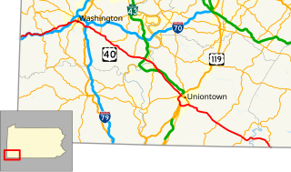
U.S. Route 40 enters Pennsylvania at West Alexander. It closely parallels I-70 from West Virginia until it reaches Washington where it follows Jefferson Avenue and Maiden Street. In Washington, US 40 passes to the south of Washington & Jefferson College. Following Maiden Street out of town, the road turns southeast toward the town of California. A short limited access highway in California and West Brownsville provides an approach to the Lane Bane Bridge across the Monongahela River. From here, the road continues southeast to Uniontown.

The PPR Port Perry Bridge is a truss bridge that carries the Norfolk Southern Railway across the Monongahela River between the Pennsylvania towns of North Versailles Township, and Duquesne. The bridge was built to serve the Pennsylvania Railroad, to provide better access to industrial sites, and to help through trains bypass downtown Pittsburgh. Today, the bridge and corresponding route serve a similar purpose and are used to allow high-level loads, especially double-stacked container cars, to avoid the narrower routes through Pittsburgh.
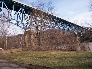
The Lane Bane Bridge is a truss bridge that carries vehicular traffic across the Monongahela River between Brownsville, Pennsylvania and West Brownsville, Pennsylvania. The high level bridge was constructed in 1960 and was originally designed to be part of the Mon-Fayette Expressway. A 3 miles (4.8 km) freeway segment stretches from the west bank of the bridge, and a final exit is contained directly on the eastern shore. The structure is designed not only to provide a river crossing without having to enter the associated deep valley, but it also carries vehicles high above the main streets of West Brownsville.

The Brownsville Bridge, also known as the Intercounty Bridge and the West Brownsville Bridge, is a truss bridge that carries vehicular traffic across the Monongahela River between Brownsville, Pennsylvania and West Brownsville, Pennsylvania. Since the opening of the Lane Bane Bridge and highway project to carry much of the intercounty through traffic away from the main streets of downtown Brownsville in the early 1960s, another commonly heard name is Old Brownsville Bridge for the four high level viaduct.

Pennsylvania Railroad, Connecting Railway Bridge is a stone arch bridge in Philadelphia, Pennsylvania, that carries Amtrak Northeast Corridor rail lines and SEPTA and NJT commuter rail lines over the Schuylkill River. It is located in Fairmount Park, just upstream from the Girard Avenue Bridge.

The Philadelphia and Reading Railroad, Bridge at West Falls is a stone and iron plate girder bridge in Philadelphia, Pennsylvania that carries two CSX Trenton Subdivision tracks over Kelly Drive, Schuylkill River, and Martin Luther King Drive.
Blainsburg is an unincorporated outlier community of West Brownsville, PA; by tradition a hamlet sized neighborhood with more actual housing acreage than West Brownsville proper in Washington County, Pennsylvania, United States. Named after a U.S. Senator, James G. Blaine. Blainsburg is part of the California Area School District. West Brownsville residence students attend Brownsville Area School District in Fayette County, Pennsylvania.The bedroom community is situated on the bluff above and slightly North-northwest of West Brownsville on the river bottom below. Blainsburg is located alongside but above the climb PA Route 88 makes from the W. Brownsville river flats which bends right entering a shelf where it connects with the northwest streets of Blainsburg before taking a second ascent towards California. The parent and child communities are on the inside curve of a great meander in the Monongahela River in Southwestern Pennsylvania creating a degraded cut bank turned ramp and terrace on the opposite shore where Brownsville is situated.Blainsburg is often misspelled with an "E" in it,to match the spelling of its namesake, James G. Blaine. Blainsburg as of official records was founded & is still spelled without the "E".
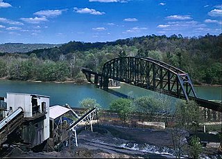
The New Geneva Bridge is a truss bridge that carries the Norfolk Southern Railway across the Monongahela River between Nicholson Township and Monongahela Township, Pennsylvania. The bridge was originally built to serve the Monongahela Railroad; it has long been part of a heavily traveled coal route. At the time of construction, it was the largest bridge ever constructed using end launching. The structure is just upriver from Friendship Hill National Historic Site.

The Oil City Pennsylvania Railroad Bridge is a truss bridge that carries the Western New York and Pennsylvania Railroad (WNY&P) across the Allegheny River between Cranberry Township and Oil City, Pennsylvania. The bridge was originally built to serve the Pennsylvania Railroad as part of its Buffalo Line. WNY&P is the fourth owner of the structure. After the breakup of the Pennsy, Conrail took ownership of the line. The breakup of these company saw Norfolk Southern assigned the rights; the WNY&P took ownership in 2006 as they extended their trackage from Meadville, Pennsylvania to Oil City. Because the bridge once served as a major junction point for several Pennsylvania Railroad lines, it features a unique approach structure. One section went from Oil City through Tidioute, Pennsylvania and then on to Warren, Pennsylvania. Conrail abandoned this line in 1976, but it may re-open so that the WNYP has a direct route to Warren.

The Point Bridge was a steel cantilever truss bridge that spanned the Monongahela River in Pittsburgh, Pennsylvania.

The Mon Line is an 85-mile long Norfolk Southern rail line which runs along the Monongahela River for most of its route.


