The National Road was the first major improved highway in the United States built by the federal government. Built between 1811 and 1837, the 620-mile (1,000 km) road connected the Potomac and Ohio Rivers and was a main transport path to the West for thousands of settlers. When improved in the 1830s, it became the second U.S. road surfaced with the macadam process pioneered by Scotsman John Loudon McAdam.

Interstate 79 (I-79) is an Interstate Highway in the Eastern United States, designated from I-77 in Charleston, West Virginia, north to Pennsylvania Route 5 (PA 5) and PA 290 in Erie, Pennsylvania. It is a primary thoroughfare through western Pennsylvania and West Virginia and makes up part of an important corridor to Buffalo, New York, and the Canada–United States border. Major metropolitan areas connected by I-79 include Charleston and Morgantown in West Virginia and Greater Pittsburgh and Erie in Pennsylvania.

Belle Vernon is a borough in Fayette County, Pennsylvania, United States. It is situated along the Monongahela River, abutting two other counties, Westmoreland to the north and Washington across the river. As of the 2020 census, Belle Vernon had a population of 1,025.

Speers is a borough that is located in Washington County, Pennsylvania, United States. The population was 1,087 at the time of the 2020 census.

Rostraver Township is a township in Westmoreland County, Pennsylvania, United States. The population was 11,374 at the 2020 census.

Downtown Pittsburgh, colloquially referred to as the Golden Triangle, and officially the Central Business District, is the urban downtown center of Pittsburgh, Pennsylvania, United States. It is located at the confluence of the Allegheny River and the Monongahela River whose joining forms the Ohio River. The triangle is bounded by the two rivers.

The Pittsburgh, Cincinnati, Chicago and St. Louis Railroad, commonly called the Pan Handle Route, was a railroad that was part of the Pennsylvania Railroad system. Its common name came from its main line, which began at Pittsburgh, Pennsylvania, crossed the Northern Panhandle of West Virginia, and continued west to Bradford, Ohio, where it split into a northern line to Chicago and a southern one through Indianapolis, Indiana, to East St. Louis, Illinois.

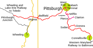
The Pittsburgh and West Virginia Railway was a railroad in the Pittsburgh, Pennsylvania, and Wheeling, West Virginia, areas. Originally built as the Wabash Pittsburgh Terminal Railway, a Pittsburgh extension of George J. Gould's Wabash Railroad, the venture entered receivership in 1908, and the line was cut loose. An extension completed in 1931 connected it to the Western Maryland Railway at Connellsville, Pennsylvania, forming part of the Alphabet Route, a coalition of independent lines between the Northeastern United States and the Midwest. It was leased by the Norfolk and Western Railway in 1964 in conjunction with the N&W acquiring several other sections of the former Alphabet Route but was leased to the new spinoff Wheeling and Lake Erie Railway in 1990, just months before the N&W was merged into the Norfolk Southern Railway.

The Panhandle Bridge carries the three lines of the Port Authority Light Rail Network across the Monongahela River in Pittsburgh, Pennsylvania. The name comes from Pennsylvania Railroad subsidiary Pittsburgh, Cincinnati, Chicago and St. Louis Railroad, also known as the Panhandle Route, which operated over the bridge.

The Glenwood Bridge is a cantilever bridge in Pittsburgh, Pennsylvania, which carries Pennsylvania Route 885 over the Monongahela River. It started construction on June 3, 1958. It was completed in 1966 to replace an old, decayed, unsafe iron bridge built in 1894, which carried Pittsburgh Railways streetcar tracks and vehicle traffic on a wooden deck.

George Westinghouse Memorial Bridge in East Pittsburgh, Pennsylvania, carries U.S. Route 30, the Lincoln Highway, over the Turtle Creek Valley near to where it joins the Monongahela River Valley east of Pittsburgh. The reinforced concrete open-spandrel deck arch bridge has a total length of 1,598 feet (487 m) comprising five spans. The longest, central span is 460 feet (140 m), with the deck height 240 feet (73 m) above the valley floor, for a time the world's longest concrete arch span structure. It cost $1.75 million. The design engineers were Vernon R. Covell and George S. Richardson, with architectural design by Stanley Roush. The pylons at the ends of the bridges feature Art Deco reliefs by Frank Vittor.

Interstate 70 (I-70) is an Interstate Highway that is located in the Commonwealth of Pennsylvania in the United States. It runs east to west across the southwest part of Pennsylvania and serves the southern fringe of the Pittsburgh metropolitan area.

Pennsylvania Route 88 is a 68-mile-long (109 km) north–south state highway located in southwestern Pennsylvania. The southern terminus of the route is at U.S. Route 119 (US 119) in Point Marion less than 2 miles (3 km) from the Pennsylvania-West Virginia border. The northern terminus is at PA 51 in Pittsburgh. PA 88 runs parallel to the Monongahela River for almost its entire length.

The Wabash Tunnel is a former railway tunnel and presently an automobile tunnel through Mt. Washington in the city of Pittsburgh, Pennsylvania, United States. Constructed early in the 20th century by railroad magnate George J. Gould for the Wabash Railroad, it was closed to trains and cars between 1946 and 2004.

Pennsylvania Route 906 is a 10.6-mile-long (17.1 km) state highway located in Fayette, Westmoreland, and Allegheny counties in Pennsylvania. The southern terminus is at PA 201 in Washington Township. The northern terminus is at PA 136 in Forward Township.

U.S. Route 40 enters Pennsylvania at West Alexander. It closely parallels Interstate 70 (I-70) from West Virginia until it reaches Washington, where it follows Jefferson Avenue and Maiden Street. In Washington, US 40 passes to the south of Washington & Jefferson College. Following Maiden Street out of town, the road turns southeast toward the town of California. A short, limited-access highway in California and West Brownsville provides an approach to the Lane Bane Bridge across the Monongahela River. From here, the road continues southeast to Uniontown.

The W.D. Mansfield Memorial Bridge, commonly known as the Dravosburg Bridge, is a cantilever bridge that carries vehicular traffic across the Monongahela River between McKeesport, Pennsylvania and Dravosburg, Pennsylvania in the United States.

The Speers Railroad Bridge, also called the Belle Vernon Railroad Bridge, carries the Wheeling and Lake Erie Railway across the Monongahela River from Speers east to North Belle Vernon in the state of Pennsylvania. The structure was originally designed by the Pittsburgh and West Virginia Railroad using a K-truss style that is rarely used outside of the Great Plains. The high-level span passes feature several smaller approach segments on the river's eastern bank due to the width of the valley.
The Masontown Bridge is a four-lane, concrete, plate girder bridge that carries vehicular traffic across the Monongahela River between Masontown, Pennsylvania and Monongahela Township, Pennsylvania, by way of Pennsylvania Route 21.
The Mon–Fayette Expressway Bridge, officially known as the PFC Ronald C. "Smokey" Bakewell Bridge, is a high-level, girder bridge that carries vehicular traffic across the Monongahela River between Luzerne Township in Fayette County, Pennsylvania and Centerville in Washington County, Pennsylvania.


