Related Research Articles

Krakatoa, also transcribed Krakatau, is a caldera in the Sunda Strait between the islands of Java and Sumatra in the Indonesian province of Lampung. The caldera is part of a volcanic island group comprising four islands. Two of them are known as Lang and Verlaten; another, Rakata, is the only remnant of an island mostly destroyed by an eruption in 1883 which created the caldera.

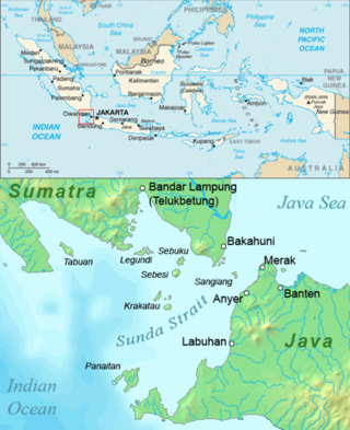
Sumatra is one of the Sunda Islands of western Indonesia. It is the largest island that is fully within Indonesian territory, as well as the sixth-largest island in the world at 482,286.55 km2 (182,812 mi.2), including adjacent islands such as the Simeulue, Nias, Mentawai, Enggano, Riau Islands, Bangka Belitung and Krakatoa archipelago.

The Sunda Strait is the strait between the Indonesian islands of Java and Sumatra. It connects the Java Sea with the Indian Ocean.

Lampung, officially the Province of Lampung, is a province of Indonesia. It is located on the southern tip of the island of Sumatra. It has a short border with the province of Bengkulu to the northwest, and a longer border with the province of South Sumatra to the north, as well as a maritime border with the provinces of Banten and Jakarta to the east. It is the home of the Lampung people, who speak their own language and possess their own written script. Its capital city is Bandar Lampung.

The Java Sea is an extensive shallow sea on the Sunda Shelf, between the Indonesian islands of Borneo to the north, Java to the south, Sumatra to the west, and Sulawesi to the east. Karimata Strait to its northwest links it to the South China Sea. It is a part of the western Pacific Ocean.

Ujung Kulon National Park is a national park at the westernmost tip of Java, located in Sumur District of Pandeglang Regency, part of Banten province in Indonesia. It once included the volcanic island group of Krakatoa in Lampung province, although current maps has suggested the Krakatoa island group as its own protected area, the Pulau Anak Krakatau Marine Nature Reserve.
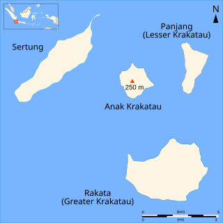
Rakata, also called Greater Krakatau, is a partially collapsed and uninhabited stratovolcano on the Indonesian island of Krakatoa in the Sunda Strait between the islands of Sumatra and Java. Standing 813 m (2,667 ft) tall, it was the largest and southernmost of three volcanoes that formed the island Krakatoa and the only one not totally destroyed in the 1883 eruption. Rakata is the last remnant of the original island prior to its destruction. However, Rakata did lose its northern half in that eruption, leaving just its southern half. The exposed cliff is quite striking visually, partially of a large exposed dike terminating in a large lenticular extrusion at the middle of the almost vertical cliff. The feature has been called "the Eye of Krakatoa."

Anak Krakatau is a volcanic island in Indonesia. On 29 December 1927, Anak Krakatau first emerged from the caldera formed in 1883 by the explosive volcanic eruption that destroyed the island of Krakatoa. There has been sporadic eruptive activity at the site since the late 20th century, culminating in a large underwater collapse of the volcano, which caused a deadly tsunami in December 2018. There has been subsequent activity since. Owing to its young age the island is one of several in the area that are of interest to, and the subject of extensive study by volcanologists.
Verlaten Island is a volcanic island. It may have been created in the 535 AD eruption of Krakatoa. It is located in the Sunda Strait in Indonesia, between Java and Sumatra. It is part of the Krakatoa Archipelago, above the famous Krakatoa volcano. Other than some minor collapse in the southeast, Verlaten suffered little damage in the 1883 eruption. Instead, it grew almost three times in area due to pumice fall, although most of the gain was quickly eroded away.

Anyer, also known as Anjer or Angier, is a coastal town in Banten, formerly West Java, Indonesia, 82 miles (100 km) west of Jakarta and 15 kilometers (9 mi) south of Merak. A significant coastal town late 18th century, Anyer faces the Sunda Strait.
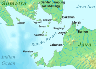
Sebesi is an Indonesian island in the Sunda Strait, between Java and Sumatra, and part of the province of Lampung. It rises to a height of 844 metres (2,769 ft) and lies about 12 kilometres (7.5 mi) north of the Krakatoa Archipelago; it is the closest large island to Krakatoa, about the same area and height as the remnant of Rakata. Like Krakatoa, it too is volcanic, although no dated eruptions are known. Unlike the Krakatoa Archipelago, Sebesi has permanent streams and is inhabited. Habitation is concentrated most heavily on the northern and eastern coasts of the island.
Krakatoa, also known as Krakatau, is a volcano in Indonesia.
Panaitan is an island in the Sunda Strait, between Java and Sumatra, and in the Indonesian province of Banten. It is the largest island in the strait, and is located near the westernmost tip of Java. Like the nearby Krakatoa, it too is volcanic in origin, although there are no known historic eruptions. The name 'Prince's Island' apparently is because the island was considered the property of Javan princes. Administratively, the island is a part of Pandeglang Regency.

Sebuku is an island in the Sunda Strait between Java and Sumatra. It is one of the larger islands in the strait and lies just 2.5 km (1.6 mi) to the north of Sebesi and 2.3 kilometres (1.4 mi) south of Sumatra. It is administratively part of South Lampung Regency, Lampung.
Krakatoa, in the Sunda Strait in Indonesia, has attracted a significant literature and media response to the 1883 eruption and subsequent events in the vicinity.

The 1883 eruption of Krakatoa in the Sunda Strait occurred from 20 May until 21 October 1883, peaking in the late morning of 27 August when over 70% of the island of Krakatoa and its surrounding archipelago were destroyed as it collapsed into a caldera.
Liman river or Ci Liman is the name of a river located at the western tip of Java Island, Banten Province, Indonesia. It originates from its headwaters in the southern mountains of Banten, around the Sareweh in the Lebak Regency, near the settlement of the Baduy Dalam tribe. It flows westward towards the coast in the Panimbang, region of Pandeglang and empties into Lada Bay, the Sunda Strait. It is approximately 73 km from the center of Cilegon city to the mouth of the river.

South Lampung Regency is a regency of Lampung, Sumatra, Indonesia, a strip of land surrounding the provincial capital of Bandar Lampung on its northern and eastern sides. The regency is bounded to the west by the new Pesawaran Regency, to the northeast by the East Lampung Regency, and to the south by the Sunda Strait; as such it is a major transit corridor to/from Java island. It has an area of 2,109.74 km2, and a population of 909,989 at the 2010 census and 1,064,301 at the 2020 census; the official estimate as at mid 2023 was 1,101,376. The regency seat is the town of Kalianda.

The Krakatoa Archipelago is a small uninhabited archipelago of volcanic islands formed by the Krakatoa stratovolcano located in the Sunda Strait, nestled between the much larger islands of Java and Sumatra. As of 2018, the archipelago consists of four main islands: Verlaten, Lang, Rakata, and the currently volcanically active Anak Krakatoa. Together, the islands are a part of the Indonesian island arc system, created by the northeastward subduction of the Indo-Australian Plate. As part of a dynamic volcanic system, the islands have been continuously reshaped throughout recorded history, most notably in the 1883 eruption of Krakatoa.
References
- ↑ Furneaux, Rupert (1964). "Krakatoa".
6°5′32″S105°27′27″E / 6.09222°S 105.45750°E
| | This Lampung location article is a stub. You can help Wikipedia by expanding it. |