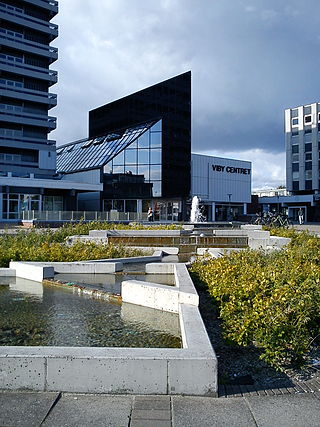
Viby J is a former town and now a district, in the southwestern part of Aarhus in Denmark. The district has almost 30,000 inhabitants. The "J" stands for Jutland, as there is another town called Viby on the island of Zealand, officially referred to as Viby Sj and also a village on Funen.

Aarhus C is a postal district in the city of Aarhus, Denmark, consisting of the Inner city, Vesterbro, University of Aarhus, Frederiksbjerg, Langenæs and Aarhus Ø, with postal code 8000. The district is commonly defined as the area enclosed by the ring road of Ring 1, and in the west by the Aarhus Harbour and shoreline.

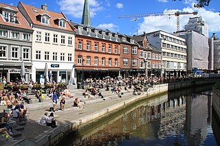
Midtbyen, also known as Aarhus Center or City, is the inner part of Aarhus. Midtbyen is part of district Aarhus C, mainly with postal code 8000, together with Vesterbro, Nørre Stenbro Trøjborg and Frederiksbjerg and has a population of around 90000.

Vesterbro is a neighbourhood of Aarhus, Denmark. It is located in the Aarhus C district, west of the city centre of Indre By. Vesterbro used to be farmland outside the city walls, and the neighbourhood's development progressed, when the city walls of Aarhus were demolished in 1851.

Vesterbrogade is the main shopping street of the Vesterbro district of Copenhagen, Denmark. The 1.5 km long street runs from the City Hall Square in the east to Pile Allé in Frederiksberg in the west where it turns into Roskildevej. On its way, it passes Copenhagen Central Station as well as the small triangular square Vesterbros Torv. It is one of four such -bro streets, the other being Nørrebrogade, Østerbrogade and Amagerbrogade.

Borgergade is a street in central Copenhagen, Denmark. It runs from Gothersgade to Store Kongensgade. As one of relatively few streets in central Copenhagen, the street, in its western part, is dominated by modern buildings. The eastern part passes through the Nyboder district.

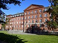
Langelandsgade Kaserne is a former military barracks in Aarhus, Denmark. It was used by the military from 1889 to 1993, when Aarhus University took ownership. After a restoration, it is now the headquarters of the Aarhus University department School of Communication and Culture .

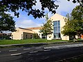
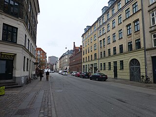
Trøjborg is a neighborhood in the city of Aarhus, Denmark in Skt. Johannes parish with about 11,000 residents as of 2015. The neighborhood is part of the district Aarhus N and borders the neighborhoods Nørre Stenbro to the South West, Risskov to the North and Riis Skov and the Bay of Aarhus to the East. Trøjborg is delimited by the streets Dronning Margrethesvej, Trøjborgvej and Nordre Ringgade.
Indre By is a neighborhood in the city of Aarhus, Denmark. The neighborhood is bounded by Nørre Allé, Vester Allé and Sønder Allé and is composed of the neighborhood and historical centre of the Latin Quarter and the areas around the Central Station and the City Hall Park. The neighborhood is one of the three main neighborhoods in the district of Aarhus C, along with Frederiksbjerg and Vesterbro.
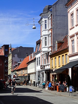
Vestergade is a street in Aarhus, Denmark, which runs east to west from the central square of Store Torv to the city park of Åparken at Carl Blochs Gade, intersecting the main streets of Grønnegade and Vester Allé along its course. Vestergade begins in the Indre By neighborhood and ends in neighborhood of Vesterbro, close to CeresByen. Vestergade has some of the best preserved 18th-century merchant estates in Aarhus and a history of creativity and artistic expression.

Nyelandsvej is a street in the Frederiksberg district of Copenhagen, Denmark. It runs from Falkoner Allé in the southeast to a roundabout at the north end of Dalgas Boulevard in the northwest. The more urban, eastern part of the street, between Falkoner Allé and Nordre Fasanvej, separates an area with Copenhagen Business School's Solbjerg Campus and Frederiksberg Centret to the south from the Svømmehal Quarter to the north. The western part of the street is passes the multi-purpose venue Keddelhallen and Frederiksberg Hospital before entering an area with Single-family detached homes.

Skolegade is a street in Aarhus, Denmark which runs north to south from Mejlgade to Mindebrogade. The street is situated in the Midtbyen neighborhood. Skolegade is home to two listed buildings and runs past the Aarhus Theater. Skolegade is an area with many bars and eateries, and it has a lively nightlife. The street is from at least medieval times with many historic buildings.

The Levin House is a Historicist property located on Gammelholm's Havnegade waterfront in central Copenhagen, Denmark. Designed by Johan Daniel Herholdt and completed in 1866, it is one of the first buildings that was completed after the former Naval dockyard came under redevelopment in the 1860s. The building is today owned by the Karberghus company and occupied by a law firm. It was listed in 1978.

The architecture of Aarhus comprises numerous architectural styles and works from the Middle Ages to present-day. Aarhus has a well-preserved medieval city center with the oldest dwellings dating back to the mid-1500s and some ecclesiastical structures such as St. Clemen's Cathedral and numerous smaller churches that can be traced back to the 1100s. The industrialization of the 19th and 20th centuries left distinctive industrial structures, important National romantic works and some of the best examples of Functionalist architecture in the country. The history of the city as a Viking fort is evidenced in the street layout of the Latin Quarter, the wider Indre By neighborhood testifies to its later role as a Market town and center of commerce while the Frederiksbjerg, Trøjborg and Marselisborg districts showcase the first cohesive urban planning efforts of the early 20th century.

Vesterbro Torv is a public square located in the Vesterbro neighborhood of Aarhus, Denmark. Vesterbro Torv is the junction where 8 street meet; Vesterbrogade, Hjortensgade, Langelandsgade, Teglværksgade, Nørre Allé, Vesterport, Vester Allé and Janus la Cours Gade. It is one of the most heavily trafficked areas in the city, receiving traffic from Åbyhøj and Brabrand in the west along Silkeborgvej and from Tilst in the north-west along Viborgvej. The square is designed as a central "island" surrounded by streets. The central part is primarily used for parking although there is a few recreational facilities such as public toilets and benches.
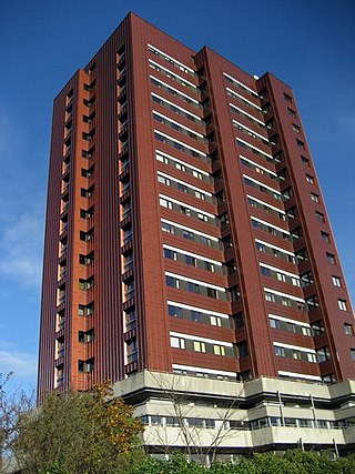
Højhuset Langenæs is a building on Langenæs Alle in the Langenæs neighborhood in Aarhus, Denmark. It is one of only two high-rise buildings in Denmark constructed from brick. It was one of the first high-rises in Aarhus and it is one of the tallest buildings in both Aarhus and Denmark; in 2017 it was the 7th tallest building in Aarhus and the 30th tallest building in Denmark. Højhuset Langenæs is a residential building owned and originally constructed by the housing organization Arbejdernes Andels Boligforening and it is composed of rental apartment units.

Valdemarsgade is a street in the Vesterbro district of Copenhagen, Denmark. It runs from Vesterbrogade in the north to Sønder Boulevard in the south, intersecting Istedgade and Dybølsgade on the way. St. Matthew's Church, Vesterbro's oldest and largest church, is located in the street. Most of the street is lined with five-storey, late 18th-century apartment blocks but its northern end stands out from the surrounding neighbourhood with its low, detached buildings with small front gardens. One of the properties, De Suhrske Friboliger, is listed on the Danish registry of protected buildings and places.

The Composers' Quarter or Strandvej Quarter, confusingly also known as the Kildevæld Quarter, or the Svanemølle Quarter, is an enclave of terraced houses located just west of Svanemøllen Station, between Østerbrogade and Kildevækd Park, in the Østerbro district of Copenhagen, Denmark. Most of the streets in the area are named after Danish or Nordic composers. The 393 townhouses were originally built by the Workers' Building Society to provide affordable and healthy housing for working-class families, though latterly they have become very desirable middle-class homes.
Enghavevej is a major street in the Vesterbro and Kongens Enghave districts of Copenhagen, Denmark. It runs from Vesterbrogade in the north to Sydhavns Plads in the south, linking Kingosgade with Sydhavnsgade and Borgbjergsvej.
Gasværksvej is a street in the Vesterbro district of Copenhagen, Denmark. It runs from Vesterbros Torv in the north to Halmtorvet in the south.