
The Neolithic or New Stone Age is an archaeological period, the final division of the Stone Age in Europe, Asia and Africa. It saw the Neolithic Revolution, a wide-ranging set of developments that appear to have arisen independently in several parts of the world. This "Neolithic package" included the introduction of farming, domestication of animals, and change from a hunter-gatherer lifestyle to one of settlement. The term 'Neolithic' was coined by Sir John Lubbock in 1865 as a refinement of the three-age system.
Tell Abu Hureyra is a prehistoric archaeological site in the Upper Euphrates valley in Syria. The tell was inhabited between 13,000 and 9,000 years ago in two main phases: Abu Hureyra 1, dated to the Epipalaeolithic, was a village of sedentary hunter-gatherers; Abu Hureyra 2, dated to the Pre-Pottery Neolithic, was home to some of the world's first farmers. This almost continuous sequence of occupation through the Neolithic Revolution has made Abu Hureyra one of the most important sites in the study of the origins of agriculture.

Maiden Castle is an Iron Age hillfort 1.6 mi (2.6 km) southwest of Dorchester, in the English county of Dorset. Hill forts were fortified hill-top settlements constructed across Britain during the Iron Age.

The term Danubian culture was coined by the Australian archaeologist Vere Gordon Childe to describe the first agrarian society in Central Europe and Eastern Europe. It covers the Linear Pottery culture, stroked pottery and Rössen cultures.

The Vinča culture (ʋîːntʃa), also known as Turdaș culture, Turdaș–Vinča culture or Vinča-Turdaș culture, is a Neolithic archaeological culture of Southeast Europe, dated to the period 5700–4500 BC or 5300–4700/4500 BC. Named for its type site, Vinča-Belo Brdo, a large tell settlement discovered by Serbian archaeologist Miloje Vasić in 1908, it represents the material remains of a prehistoric society mainly distinguished by its settlement pattern and ritual behaviour.

The Goseck Circle is a Neolithic structure in Goseck in the Burgenlandkreis district in Saxony-Anhalt, Germany.

Bylany is a Danubian Neolithic archaeological site located around 65 km (40 mi) east of Prague in the Czech region of Bohemia. Excavation began in 1955 and work continues today.

Celtic field is an old name for traces of early (prehistoric) agricultural field systems found in North-West Europe, i.e. Britain, Ireland, Belgium, Netherlands, Germany, Denmark, France, Sweden, Poland and the Baltic states. The fields themselves are not related to the Celtic culture.

Mount Caburn is a 150-metre prominent landmark in East Sussex, England, about one mile (1.6 km) east of Lewes overlooking the village of Glynde. It is the highest part of an outlier of the South Downs, separated from the main range by Glynde Reach, a tributary of the River Ouse.

The Oppidum of Manching was a large Celtic proto-urban or city-like settlement at modern-day Manching, near Ingolstadt, in Bavaria, Germany. The Iron Age town was founded in the 3rd century BC and existed until c. 50-30 BC. It reached its largest extent during the late La Tène period, when it had a size of 380 hectares. At that time, 5,000 to 10,000 people lived within its 7.2 km walls. Thus, the Manching oppidum was one of the largest settlements north of the Alps. The ancient name of the site is unknown, but it is assumed that it was the central site of the Celtic Vindelici tribe.
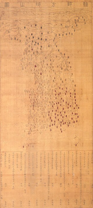
The Mumun pottery period is an archaeological era in Korean prehistory that dates to approximately 1500-300 BC. This period is named after the Korean name for undecorated or plain cooking and storage vessels that form a large part of the pottery assemblage over the entire length of the period, but especially 850-550 BC.

The Chiripa culture existed between the Initial Period/Early Horizon, from 1400 to 850 BCE along the southern shore of Lake Titicaca in Bolivia.

Poundbury Hill is the site of a scheduled Prehistoric and Roman archaeological remains and includes evidence of a Neolithic settlement, a substantial Bronze Age occupation site and an Iron Age hillfort. There are also late Iron Age burials and a section of Roman aqueduct. On the eastern side is an earlier Romano-British farmstead; and an extensive later cemetery, belonging to the Roman town Durnovaria.
Daepyeong is a complex prehistoric archaeological site located in the Nam River valley near Jinju in South Gyeongsang Province, South Korea. Pottery typologies and seriations and a host of AMS radiocarbon dates show that the site had a number of occupations over several millennia from c. 3500 BC - AD 500.
A nucleated village, or clustered settlement, is one of the main types of settlement pattern. It is one of the terms used by geographers and landscape historians to classify settlements. It is most accurate with regard to planned settlements: its concept is one in which the houses, even most farmhouses within the entire associated area of land, such as a parish, cluster around a central church, which is perhaps close to the village green. Other possible focal points, depending on cultures and location, are a commercial square, circus, crescent, railway station, park or sports stadium.
A dispersed settlement, also known as a scattered settlement, is one of the main types of settlement patterns used by landscape historians to classify rural settlements found in England and other parts of the world. Typically, there are a number of separate farmsteads scattered throughout the area. A dispersed settlement contrasts with a nucleated village. It can be known as main human settlements.

Aşıklı Höyük is a settlement mound located nearly 1 kilometre (0.62 mi) south of Kızılkaya village on the bank of the Melendiz brook, and 25 km (16 mi) southeast of Aksaray, Turkey. Aşıklı Höyük is located in an area covered by the volcanic tuff of central Cappadocia, in Aksaray Province. The archaeological site of Aşıklı Höyük was first settled in the Pre-Pottery Neolithic period, around 8,200 BC.
Hillforts in Britain refers to the various hillforts within the island of Great Britain. Although the earliest such constructs fitting this description come from the Neolithic British Isles, with a few also dating to later Bronze Age Britain, British hillforts were primarily constructed during the British Iron Age. Some of these were apparently abandoned in the southern areas that were a part of Roman Britain, although at the same time, those areas of northern Britain that remained free from Roman occupation saw an increase in their construction. Some hillforts were reused in the Early Middle Ages, and in some rarer cases, into the Later Medieval period as well. By the early modern period, these had essentially all been abandoned, with many being excavated by archaeologists in the nineteenth century onward.
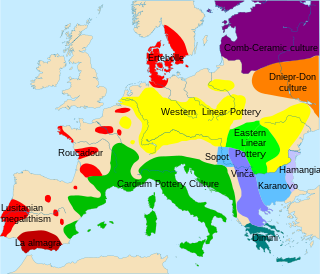
The Linear Pottery culture (LBK) is a major archaeological horizon of the European Neolithic period, flourishing c. 5500–4500 BC. Derived from the German Linearbandkeramik, it is also known as the Linear Band Ware, Linear Ware, Linear Ceramics or Incised Ware culture, falling within the Danubian I culture of V. Gordon Childe.
Magheraboy causewayed enclosure is an early Neolithic enclosure located near Sligo town in northwest Ireland.