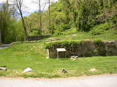

Lapidum is a ghost town in Harford County, Maryland, USA, located at the head of navigation of the Susquehanna River on the west bank across from Port Deposit.
Lapidum is a ghost town in Harford County, Maryland, USA, located at the head of navigation of the Susquehanna River on the west bank across from Port Deposit.
Lapidum traces its history to the granting of early land patents for the tracts known as "Eightrapp" (1665), "Faton" (1679) and "Land of Promise" (1684). As settlers transformed the surrounding land from forest to farmland the area grew in importance as a commercial center. Fields of corn and tobacco were grown on land near the river, and an important fishing industry also developed, based on the runs of shad and herring. [1]
A ferry was established between this point and Port Deposit in the 1720s and operated until the completion of the bridge from Port Deposit to the Rock Run Mill just upstream of Lapidum in 1818. In 1729, Thomas Cresap established a regular ferry service near Smith's Falls (in the upper Port Deposit area) crossing the Susquehanna to Lapidum; this was referred to as Smith's Ferry or Upper Ferry (there was a lower ferry at the mouth of the Susquehanna River just off the Chesapeake Bay). In 1731, a road from Susquehanna Upper Ferry toward Philadelphia, as far as the jurisdiction extends, was authorized. In the same year, in the jurisdiction south of the river, a petition was submitted for a road from the mill at Rock Run just above Lapidum to Peach Bottom, Pennsylvania. This upper ferry came to be known as "Creswell's Ferry." [2] [3]
A three-story Victorian building, the Susquehanna Hotel, was built here by Conrad Baker in 1868. It was constructed of stone, brick and framed with lumber, and included several large porches. Other buildings included a church, a mill, a Masonic hall, a school, and numerous houses, stores and warehouses as well as wharves to serve the trade from goods being brought down the Susquehanna River or by road from the adjacent countryside to be loaded onto ships. [1]
Lapidum profited from the financial success of the ferry, the Susquehanna and Tidewater Canal, and from its location as one of the highest deepwater landings for Chesapeake Bay shipping.
By 1900, the sources of Lapidum's commerce and prosperity were lost to railroad competition. Ice accumulations (referred to locally as "ice gorges") eventually destroyed the warehouses and wharves. The hotel continued as a fishing lodge and men's club until the 1960s, when it was torn down.
The land is currently part of Susquehanna State Park in Maryland.

Cecil County is a county located in the U.S. state of Maryland at the northeastern corner of the state, bordering both Pennsylvania and Delaware. As of the 2020 census, the population was 103,725. The county seat is Elkton. The county is part of the Mid-Eastern Shore region of the state.

Port Deposit is a town in Cecil County, Maryland, United States. It is located on the east bank of the Susquehanna River near its discharge into the Chesapeake Bay. The population was 653 at the 2010 census.

Havre de Grace, abbreviated HdG, is a city in Harford County, Maryland, United States. It is situated at the mouth of the Susquehanna River and the head of Chesapeake Bay. It is named after the port city of Le Havre, France, which in full was once Le Havre de Grâce.

The James River is a river in Virginia that begins in the Appalachian Mountains and flows from the confluence of the Cowpasture and Jackson Rivers in Botetourt County 348 miles (560 km) to the Chesapeake Bay. The river length extends to 444 miles (715 km) if the Jackson River, the longer of its two headwaters, is included. It is the longest river in Virginia. Jamestown and Williamsburg, Virginia's first colonial capitals, and Richmond, Virginia's current capital, lie on the James River.

The Susquehanna River is a major river located in the Mid-Atlantic region of the United States, crossing three lower Northeast states. At 444 miles (715 km) long, it is the longest river on the East Coast of the United States. By watershed area, it is the 16th-largest river in the United States, and also the longest river in the early 21st-century continental United States without commercial boat traffic.
Claiborne is an unincorporated community in Talbot County, Maryland, United States. The village is located on the eastern shore of the Chesapeake Bay near the mouth of the Eastern Bay at 38°50′15″N76°16′40″W, and uses ZIP code 21624. The 2000 U.S. Census listed the population as 147 and the number of homes as 84, slightly down from its 1941 population of 156. Between 1890 and 1930, the village was a busy port for passenger and then automobile ferry service across the Chesapeake Bay, with numerous stores and motels/resorts, including Maple Hall and the Bellfonte Hotel. A post office was added in 1893 and the Protestant Episcopal Church of Claiborne was built in 1898. In 1912, an elementary school and Methodist Church were added. Before 1912, students attended school in nearby McDaniel. The town's first school consisted of the kitchen of the local railroad pavilion, used as a classroom. In 1913, the town became home to the Claiborne Fresh Air Association, Inc., which was formed for the purpose of providing 10 weeks of fresh air and summer vacation for children who had been exposed to tuberculosis. The role of Claiborne as a terminal for cross-Bay ferries was diminished in 1930 when the primary route shifted to Matapeake in Kent Island. It ended altogether in 1938 when the direct connection from Annapolis to Claiborne was terminated and only an auxiliary shuttle between Claiborne and Romancoke on Kent Island remained. This shuttle service ended in 1952, a few months after the opening of the Chesapeake Bay Bridge; thus ending all ferry service to Claiborne after more than six decades.

The Eastern Shore of Maryland is a part of the U.S. state of Maryland that lies mostly on the east side of the Chesapeake Bay. Nine counties are normally included in the region. The Eastern Shore is part of the larger Delmarva Peninsula that Maryland shares with Delaware and Virginia.
The Gunpowder River is a 6.8-mile-long (10.9 km) tidal inlet on the western side of the Chesapeake Bay in Maryland, United States. It is formed by the joining of two freshwater rivers, Gunpowder Falls and Little Gunpowder Falls.
The South River is a 10-mile-long (16 km) tributary of the Chesapeake Bay in Anne Arundel County, Maryland in the United States. It lies south of the Severn River, east of the Patuxent River, and north of the West River and Rhode River, and drains to the Chesapeake Bay.

Conowingo is a community in northwestern Cecil County, Maryland, United States. The community replaced a previous one that was inundated by a reservoir.

Susquehanna State Park is a public recreation area located on the banks of the lower Susquehanna River north of the city of Havre de Grace, Maryland. The state park's main area is on the west bank of the river; the park also manages land on the river islands and east bank. The park offers fishing, boating, camping, and trails for hiking and equestrian use. It is managed as a complex with Rocks State Park and Palmer State Park by the Maryland Department of Natural Resources.

Conewago Creek is an 80.2-mile-long (129.1 km) tributary of the Susquehanna River in Adams and York counties in Pennsylvania in the United States, with its watershed also draining a small portion of Carroll County, Maryland. The source is at an elevation of 1,440 feet (440 m), east of Caledonia State Park, in Franklin Township in Adams County. The mouth is the confluence with the Susquehanna River at York Haven in York County at an elevation of 259 feet (79 m).

The Great Indian Warpath (GIW)—also known as the Great Indian War and Trading Path, or the Seneca Trail—was that part of the network of trails in eastern North America developed and used by Native Americans which ran through the Great Appalachian Valley. The system of footpaths extended from what is now upper New York to deep within Alabama. Various Native peoples traded and made war along the trails, including the Catawba, numerous Algonquian tribes, the Cherokee, and the Iroquois Confederacy. The British traders' name for the route was derived from combining its name among the northeastern Algonquian tribes, Mishimayagat or "Great Trail", with that of the Shawnee and Delaware, Athawominee or "Path where they go armed".

The Helen Delich Bentley Port of Baltimore is a shipping port along the tidal basins of the three branches of the Patapsco River in Baltimore, Maryland, on the upper northwest shore of the Chesapeake Bay. It is the nation's largest port facility for specialized cargo and passenger facilities. It is operated by the Maryland Port Administration (MPA), a unit of the Maryland Department of Transportation.
Queen Anne in Prince George's County, Maryland, United States, is a former port on the Patuxent River. It was delineated as a CDP for the 2010 census, at which time it had a population of 1,280. Per the 2020 census, the population was 1,405.

The Susquehanna and Tidewater Canal between Wrightsville, Pennsylvania, and Havre de Grace, Maryland, at the head of Chesapeake Bay, provided an interstate shipping alternative to 19th-century arks, rafts, and boats plying the difficult waters of the lower Susquehanna River. Built between 1836 and 1840, it ran 43 miles (69 km) along the west bank of the river and rendered obsolete an older, shorter canal along the east bank. Of its total length, 30 miles (48 km) were in Pennsylvania and 13 miles (21 km) in Maryland. Although rivalry between Philadelphia, Pennsylvania, and Baltimore, Maryland, delayed its construction, the finished canal brought increased shipments of coal and other raw materials to both cities from Pennsylvania's interior. Competition from railroads was a large factor in the canal's decline after 1855. Canal remnants, including a lock keeper's house, have been preserved in Maryland, and locks 12 and 15 have been preserved in Pennsylvania.
The Little Magothy River runs 2.5 miles (4.0 km) through Anne Arundel County in the U.S. state of Maryland. It is located southeast of the Magothy River, just outside its mouth and north of the Severn River.
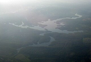
The Conejohela Flats are a group of islands in the flooded Conejohela Valley, a large floodplain along the southernmost 30 miles (50 km) of the Susquehanna River in Pennsylvania and Maryland in the United States. The valley was flooded primarily during the early 1900s by the construction of the Holtwood, Conowingo, and Safe Harbor dams from 1910 to 1931.
| International | |
|---|---|
| National | |