Aroma is one of the twenty provinces of the Bolivian La Paz Department. It is situated in the southern parts of the department. Its seat is Sica Sica.
José Manuel Pando is a province in the La Paz Department in Bolivia. It was founded on April 22, 1986 during the presidency of Víctor Paz Estenssoro. The province was named after José Manuel Pando (1848-1917) who was the president of Bolivia from 1899 till 1904. Its capital is Santiago de Machaca.

Machacamarca is a small town in the Pantaléon Dalence Province in the Oruro Department in Bolivia. It is the seat of the Machacamarca Municipality and of the Machacamarca Canton. At the time of census 2001 it had a population of 2,206. The town is situated south of Oruro near the south-eastern shore of Lake Uru Uru at the road and railway that lead to Poopó.
Taypi Chaka Quta is a lake west of the Cordillera Real of Bolivia located in the La Paz Department, Los Andes Province, Pukarani Municipality, Tuquia Canton, on the border to Batallas Municipality. It is situated at a height of about 4,412 metres (14,475 ft), south west of Sura Quta, a lake connected with Taypi Chaka Quta by the Link'u River that flows down from the Cordillera Real towards Lake Titicaca.
Janq'u Quta is a lake in the Cordillera Real of Bolivia located in the La Paz Department, Los Andes Province, Batallas Municipality, Kirani Canton. It lies north-west of the Kunturiri massif, east of Wila Lluxi and south of Janq'u Uyu. Janq'u Quta is situated at a height of about 4,940 metres (16,210 ft), about 0.95 km long and 0.38 km at its widest point.

Jach'a Jawira which downstream is named Japha Jawira is a Bolivian river east of Lake Titicaca in the La Paz Department, Los Andes Province, Batallas Municipality and in the Omasuyos Province, Achacachi Municipality. Its waters flow to Lake Titicaca via the Qiqa Jawira.

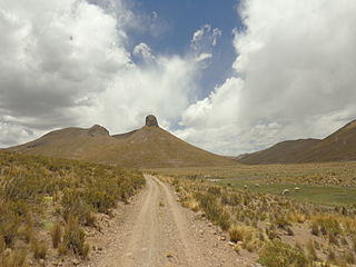
Wila Qullu is a mountain in the Andes in Bolivia, about 5,144 metres (16,877 ft) high. It is located in the Oruro Department, Challapata Province, Challapata Municipality. Wila Qullu is situated south of Jach'a River and north of Nacional Route 1. It lies north-west of the mountain Wila Quta which reaches the same height.
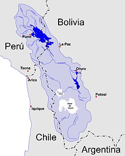
Katari River which upstream successively is named Jach'a Jawira, Colorado, Mani and then Colorado again is a river in the La Paz Department of Bolivia, about 90 km long, southeast of Lake Titicaca. It empties into Wiñaymarka Lake, the southern part of Lake Titicaca.
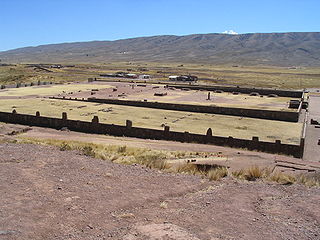
Tiwanaku River or Wakira River is a Bolivian river southeast of Lake Titicaca in the La Paz Department, Ingavi Province, in the municipalities of Guaqui and Tiwanaku, and in the Los Andes Province, Laja Municipality. It empties into Wiñaymarka Lake, the southern part of Lake Titicaca, north of Guaqui (Waki) near the villages of Jawira Pampa and Uma Marka. On its way along the southern slopes of the Taraco range it flows along the archaeological site of Tiwanaku.
Jach'a Jawira is a Bolivian river east of Poopó Lake in the Potosí Department, Rafael Bustillo Province, Chuqi Uta Municipality.
Jach'a Jawira is a Bolivian river east of Poopó Lake in the Potosí Department, Rafael Bustillo Province, Uncía Municipality.
Sura Quta is a lake west of the Cordillera Real of Bolivia located in the La Paz Department, Los Andes Province, Pukarani Municipality, Wayna Potosí Canton, on the border to Batallas Municipality. It is situated at a height of about 4,491 metres (14,734 ft), about 1.77 km long and 0.7 km at its widest point. Sura Quta lies north east of Taypi Chaka Quta. The lakes are connected by the Link'u River that flows down from the Cordillera Real towards Lake Titicaca.
Sura Quta is a small lake west of the Cordillera Real of Bolivia located in the La Paz Department, Los Andes Province, Pukarani Municipality, Patamanta Canton, south east of the Kunturiri massif and Tuni Lake. It is situated at a height of about 4,532 metres (14,869 ft), about 0.4 km long and 0.36 km at its widest point.

Urqu Jawira is a Bolivian river in the La Paz Department, Aroma Province, Calamarca Municipality.
Urqu Jawira is a Bolivian river in the La Paz Department, Pedro Domingo Murillo Province. It originates in the Wayllari mountain range. On its way to Choqueyapu River it crosses the city La Paz from north to south in the Putu Putu or Miraflores district.
Jach'a Quta is a lake in Bolivia located in the La Paz Department, Aroma Province, Calamarca Municipality, west of Calamarca.
Wila Qullu is a mountain in the Andes in Bolivia, about 5,060 metres (16,601 ft) high. It is situated in the Oruro Department, Challapata Province, Challapata Municipality, Challapata Canton. Wila Qullu lies south-east of the mountains Thuru and Wawachani and north-west of Wichhu Qullu. It is situated north of Chunkara Lake.
Chuqi Q'awa is a mountain in the Andes of Bolivia which reaches a height of approximately 4,720 m (15,490 ft). It is located in the La Paz Department, Aroma Province, Colquencha Municipality. It lies northwest of Qillqatiri.
The Ch'alla Jawira which upstream is named Ch'api K'uchu and downstream successively is called Tupa Jawira and Qura Jawira is a river in the La Paz Department in Bolivia. It is a right affluent of the Aqhuya Jawira whose waters flow to the Desaguadero River.
The Ch'alla Jawira which upstream successively is named Chilla Jawira, Pichini Jawira, Janq'u Quta and Siwinqa is a river in the La Paz Department in Bolivia. It is a left tributary of the Desaguadero River.