Larrun (modern French: La Rhune, IPA: [la'run], - 'good pasture', possibly a folk etymology, in French until the 20th century: Larhune ) is a mountain (905 m) at the western end of the Pyrenees. It is located on the border of France and Spain, where the traditional Basque provinces of Labourd and Navarra meet. Its prominence is 670 m.
Larrun holds an iconic place in Basque culture. It is covered in dolmens, stone circles and other neolithic monuments and was held to be a sacred place in Basque mythology. It was said to be the home of Lehensugea, the first serpent. Later, and perhaps as a consequence of the ancient sacred sites, the summit had a reputation as an akelarre or ritual meeting place for witches. Up until the 18th century, local villages paid for a monk to live as a hermit at the top of the mountain to keep witches away and ensure good winds.
The mountain was used by French troops as a defensive position towards the end of the Peninsular War, but Wellington's forces drove those of Marshal Soult off the mountain during the Battle of Nivelle on November 10, 1813, this action leaving France open for Wellington's successful march north to Paris. The ruins of military fortifications built from this era are still there today.
Larrun and the local area were notable smuggling routes used for centuries, including for refugees during the Spanish Civil War and World War II. Smuggling was of such importance that a local tale tells that the mountain was covered by gold until evil men came to take it away. They burned the trees on the mountain to reach the gold, but the metal melted and flowed away.
The mountain started to become a popular destination for tourists following Eugenie de Montijo's holidays in Biarritz since 1864, and her outings to its summit.
Today
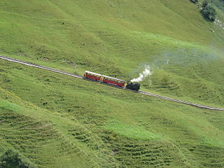
Larrun is now a popular site for walks and hikes and is the first peak encountered on the coast-to-coast Haute Randonnée Pyrénéenne (HRP) walking route. A rack railway, the Petit train de la Rhune, takes visitors to the top of the mountain from the French side. Cows, a few pottok ponies and manech sheep wander the slopes.
Many inns and restaurants bear its name and its distinctive shape adorn many souvenirs and logos.
A mountain railway is a railway that operates in a mountainous region. It may operate through the mountains by following mountain valleys and tunneling beneath mountain passes, or it may climb a mountain to provide transport to and from the summit.
Biarritz is a city on the Bay of Biscay, on the Atlantic coast in the Pyrénées-Atlantiques department in the French Basque Country in southwestern France. It is located 35 kilometres (22 mi) from the border with Spain. It is a luxurious seaside tourist destination known for the Hôtel du Palais, its seafront casinos, and its surfing culture.
Hendaye is a commune in the Pyrénées-Atlantiques department and Nouvelle-Aquitaine region of southwestern France.
The Battle of Roncevaux Pass in 778 saw a large force of Basques ambush a part of Charlemagne's army in Roncevaux Pass, a high mountain pass in the Pyrenees on the present border between France and Spain, after his invasion of the Iberian Peninsula.
Labourd is a former French province and part of the present-day Pyrénées Atlantiques département of Nouvelle-Aquitaine region. It is one of the traditional Basque provinces, and identified as one of the territorial component parts of the Basque Country by many, especially by the Basque nationalists.
Saint-Jean-de-Luz is a commune in the Pyrénées-Atlantiques department, southwestern France. Saint-Jean-de-Luz is part of the Basque province of Labourd (Lapurdi).
Akelarre is the Basque term meaning Witches' Sabbath. Akerra means male goat in the Basque language. Witches' sabbaths were envisioned as presided over by a goat.
Anglet is a commune in the Pyrénées-Atlantiques department in the Nouvelle-Aquitaine region of southwestern France.
Ascain is a commune in the Pyrénées-Atlantiques department in the Nouvelle-Aquitaine region of south-western France.
Sare is a village and a commune in the Pyrénées-Atlantiques department in south-western France on the border with Spain. It is part of the traditional Basque province of Labourd.
The French Basque Country, or Northern Basque Country, is a region lying on the west of the French department of the Pyrénées-Atlantiques. Since 1 January 2017, it constitutes the Basque Municipal Community presided over by Jean-René Etchegaray.
Sorginak are the assistants of the goddess Mari in Basque mythology. It is also the Basque name for witches, priests and priestesses, making it difficult to distinguish between the mythological and real ones.
Hernani is a town and municipality located in the province of Gipuzkoa, Basque Autonomous Community, Spain. The town sits on the left bank of the Urumea river. It is located at a distance of 9.2 km from San Sebastián. The municipality of Hernani occupies an area of approximately 40 square kilometres and is bordered by San Sebastián, Astigarraga, Arano, Elduayen, Errenteria, Lasarte-Oria and Urnieta.
The Battle of Nivelle took place in front of the river Nivelle near the end of the Peninsular War (1808–1814). After the Allied siege of San Sebastian, Wellington's 80,000 British, Portuguese and Spanish troops were in hot pursuit of Marshal Soult who had 60,000 men to place in a 20-mile perimeter. After the Light Division, the main British army was ordered to attack and the 3rd Division split Soult's army in two. By two o'clock, Soult was in retreat and the British in a strong offensive position. Soult had lost another battle on French soil and had lost 4,500 men to Wellington's 5,500.
In the Battle of the Bidasoa on 7 October 1813 the Allied army of Arthur Wellesley, Marquess of Wellington wrested a foothold on French soil from Nicolas Soult's French army. The Allied troops overran the French lines behind the Bidassoa River on the coast and along the Pyrenees crest between the Bidasoa and La Rhune (Larrun). The nearest towns to the fighting are Irun on the lower Bidassoa and Bera on the middle Bidasoa. The battle occurred during the Peninsular War, part of the wider Napoleonic Wars.
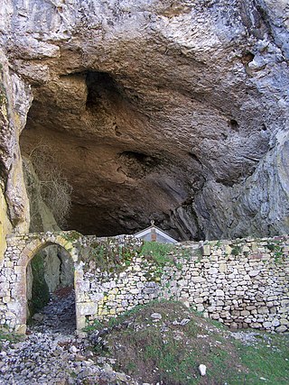
The San Adrian tunnel or Lizarrate represents the most outstanding milestone in the historic inland Basque route of the Way of St. James. It consists of a natural cave carved by water erosion in the rock with an opening on either side north and south; it also holds a hermitage inside. The tunnel provides a natural passage dividing the provinces of Gipuzkoa and Álava/Araba.
The Petit train de la Rhune or Larrungo tren ttipia is a metre gauge rack railway in France at the western end of the Pyrenees, in the Basque Country. It links the Col de Saint-Ignace, some 10 km (6.2 mi) to the east of Saint-Jean-de-Luz, to the summit of the La Rhune mountain (Larrun). Although this summit lies on the border between France and Spain, the railway lies entirely within the French département of Pyrénées-Atlantiques.
Jaizkibel is a mountain range of the Basque Country located east of Pasaia, north of Lezo and west of Hondarribia, in Spain, with 547 m (1,795 ft) at the highest point. The range stretches south-west to north-east, where it plunges into the sea at the Cape Higuer. To the north-west, the mountain dips its slopes in the sea with beautiful cliffs all along, overlooking on the east the marshes of Txingudi, the river Bidasoa and its mouth as well as the towns of Irun, Hendaia and Hondarribia on the riverbanks. The nearest relevant mountains are La Rhune, Aiako Harria and Ulia, closing the view east to west from the south. Some people consider Jaizkibel to be the first westernmost mountain of the Pyrenees.
Florentino Goikoetxea (1898–1980) was a Basque who worked for the Comet Escape Line during World II. A smuggler by profession, he guided more than 200 Allied airmen shot down in occupied Belgium and France over the Pyrenees mountains to neutral Spain from where they could be repatriated to the United Kingdom. He was honored with the George Medal from the United Kingdom and the Legion of Honor from France.
The fortifications of Larrun from the late modern period are a series of military works situated on the mountain of Larrun, immediately to the west of the border between Spain and France. Some of the structures were erected during the 1793-1794 campaign and repurposed to impede the advance of the Anglo-Hispano-Portuguese coalition troops, which the future Duke of Wellington led. More than twenty redoubts are distributed across the territories of Ascain, Sare, and Urrugne, with partial coverage also extending to those of Saint-Pée-sur-Nivelle and Biriatou.
This page is based on this Wikipedia article Text is available under the CC BY-SA 4.0 license; additional terms may apply. Images, videos and audio are available under their respective licenses.