Las Lajas, Honduras

Last updated
Las Lajas
Municipality
Honduras location map.svg
Red pog.svg
Las Lajas
Coordinates: 14°54′N87°35′W / 14.900°N 87.583°W / 14.900; -87.583
Country Flag of Honduras.svg  Honduras
Department Comayagua
Area
  Total95.1 km2 (36.7 sq mi)
Population
 (2023 projection) [1]
  Total16,840
  Density180/km2 (460/sq mi)

Las Lajas is a town, with a population of 12,000 (2023 calculation), [2] and a municipality in the Honduran department of Comayagua.

Contents

History

The village, from the 1970s to the 1980s, reached a remarkable demographic and economic development. Founded in 1902, it was created as municipality in 1986.

Geography

Hydrography

The town is crossed by the Quebrada Seca Quebrada de Daniel, also parallel to this cross the Quebrada Galana, that when entering the town some call Quebrada Mangos.

Urbanization

Las Lajas began to fill the middle of this century due to livestock grazing activities in the summer then by the need for land for agricultural activities. The nature and legal status of the lands in this region correspond to national and ejido properties during this period and had no control over them by government authorities. The first inhabitants were taking over large tracts of land and building the first homes, Rafael Flores said that the families were named Flores, Ulloa, Ponce, Buezo and Romero, founding the first quarter known as El Porvenir, thus arise first fence and the first properties of the slabs, without thinking that in the future would become a thriving community. Today the Lajas has a messy and uneven urban development in the layout of its streets. The village comprises four neighborhoods with very particular characteristics and interests that sometimes has led to some contradictions to such a degree that come even to establish great rivalries, these neighborhoods are scattered and transmitted by a single street.

The Neighborhood Center is located along a single street with more than one kilometer in length approximately at the municipal offices are located, school, the main Catholic church, civil and military authorities, parks, shopping centers, grocery stores, hotels, gas station etc. El Barrio El Porvenir, this neighborhood is just north of downtown, is served by a wide street, with churches, primary schools, petrol station, bus station etc. To the south of the downtown district, is located Suyapa neighborhood, joined the San Francisco, the San Miguel and the track, which also have their own water service, school, health center, and the Institute of secondary schools and businesses Abarroteria. In the northwestern part of the district the center is developing a neighborhood called El Carmen, who spends his time as its population increases. Finally to the west lies the New Valley, which like the other is located along a street, with the same basic services that have the other neighborhoods.

Related Research Articles

<span class="mw-page-title-main">San Lorenzo, Puerto Rico</span> Town and municipality in Puerto Rico

San Lorenzo is a town and municipality of Puerto Rico located in the eastern central region, north of Patillas and Yabucoa; south of Gurabo; east of Caguas and Cayey; and west of Juncos and Las Piedras. San Lorenzo is spread over twelve barrios and San Lorenzo Pueblo. It is part of the San Juan-Caguas-Guaynabo Metropolitan Statistical Area.

<span class="mw-page-title-main">San Pedro Sula</span> City and municipality in Cortés, Honduras

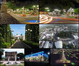
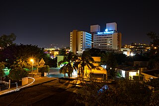
San Pedro Sula is the capital of Cortés Department, Honduras. It is located in the northwest corner of the country in the Sula Valley, about 50 kilometers south of Puerto Cortés on the Caribbean Sea. With a population of 701,200 in the central urban area and a population of 1,445,598 in its metropolitan area in 2023, it is the nation's primary industrial center and second largest city after the capital Tegucigalpa, and the largest city in Central America that is not a capital city.

<span class="mw-page-title-main">Lajas, Puerto Rico</span> Town and municipality in Puerto Rico

Lajas is a town and municipality of Puerto Rico located in the Lajas Valley in southwestern Puerto Rico, on the southern coast of the island, bordering the Caribbean Sea, south of San Germán and Sabana Grande; east of Cabo Rojo; and west of Guánica. Lajas is spread over 11 barrios plus Lajas Pueblo. It is part of the San Germán-Cabo Rojo Metropolitan Statistical Area.

<span class="mw-page-title-main">Chiquimula</span> Municipality in Guatemala

Chiquimula is a city in Guatemala. It is the capital of the department of Chiquimula and the municipal seat for the surrounding municipality of the same name. It is located some 174 km from Guatemala City and within Guatemala known as "La perla del oriente".

<span class="mw-page-title-main">Gracias</span> Municipality in Lempira, Honduras

Gracias is a small Honduran town/municipality that was founded in 1536, and is the capital of Lempira Department.

<span class="mw-page-title-main">Santa Bárbara, Honduras</span> Municipality in Santa Bárbara, Honduras

Santa Bárbara, with a population of 30,690, is the capital city of the Santa Bárbara Department of Honduras and the municipal seat of Santa Bárbara Municipality.

<span class="mw-page-title-main">Arizona, Atlántida</span> Municipality in Atlántida, Honduras

Arizona is a town, with a population of 5,779, and a municipality in the Honduran department of Atlántida.

El Porvenir is a town, with a population of 5,202, and a municipality in the Honduran department of Atlántida. The largest town of the Municipality is El Pino, with a population of 6,304.

Siguatepeque is a city and municipality in the Honduran department of Comayagua. The city has a population of 79,520.

<span class="mw-page-title-main">La Lima</span> Municipality in Cortés, Honduras

La Lima is a city, with a population of 80,740, and a municipality in the Honduran department of Cortés.

<span class="mw-page-title-main">Las Flores, Honduras</span> Municipality in Lempira, Honduras

Las Flores is a municipality in the Honduran department of Lempira.

El Negrito is a town, with an urban population of 13,260 (2023), and a municipality in the department of Yoro, Honduras.

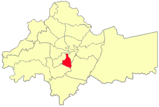
Morazán is a town, with a population of 22,240, and a municipality in the Honduran department of Yoro. This political division of 50,930 people is in the north, located between the city of Yoro and the municipality of El Negrito, north of the Nico Pijol National Park.

<span class="mw-page-title-main">Catacamas</span> Municipality in Olancho, Honduras

Catacamas is a city, with a population of 63,310, and a municipality in the Olancho Department of Honduras.

<span class="mw-page-title-main">Bosconia</span> Municipality and town in Caribbean, Colombia

Bosconia is a town and municipality in the Colombian Department of Cesar.

<span class="mw-page-title-main">Bosa, Bogotá</span> Locality of Bogotá in Bogotá D.C., Colombia

Bosa is the 7th locality of the Capital District of the Colombian capital, Bogotá. Bosa is located in the southwest of Bogotá and is the 8th largest locality and 9th most populated. This district is inhabited by working-class residents.

<span class="mw-page-title-main">Batabanó, Cuba</span> Municipality in Mayabeque, Cuba

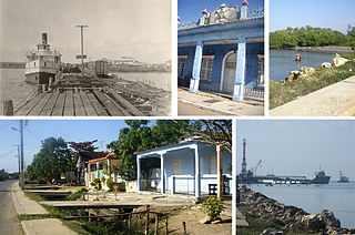
Batabanó is a municipality and town in the Mayabeque Province of Cuba. It was founded in 1688.

<span class="mw-page-title-main">San José de las Lajas</span> Municipality in Mayabeque, Cuba

San José de las Lajas is a municipality and the capital city of the newly formed Mayabeque Province of Cuba, after the segmentation of La Habana Province in 2011. It is located in the center north of the province, and is bisected by the Carretera Central.

<span class="mw-page-title-main">Tegucigalpa</span> Capital and largest city of Honduras

Tegucigalpa —formally Tegucigalpa, Municipality of the Central District, and colloquially referred to as Tegus or Teguz—is the capital and largest city of Honduras along with its sister city, Comayagüela.

<span class="mw-page-title-main">Ras Al-Ein area</span> Area in Amman, Jordan

Ras al-Ein is one of the 22 administrative sub-districts of the city of Amman, Jordan, as governed by the Greater Amman Municipality.

References

  1. Citypopulation.de Population of departments and municipalities in Honduras
  2. Citypopulation.de Population of cities in Honduras

14°54′0″N87°35′0″W / 14.90000°N 87.58333°W / 14.90000; -87.58333