Comayagua is a city, municipality and old capital of Honduras, located 80 km (50 mi) northwest of Tegucigalpa on the highway to San Pedro Sula and 594 m (1,949 ft) above sea level.
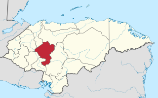
Comayagua is one of the 18 departments (departamentos) into which Honduras is divided. The departmental capital is Comayagua.

Santa Bárbara, with a population of 30,690, is the capital city of the Santa Bárbara Department of Honduras and the municipal seat of Santa Bárbara Municipality.

La Unión is a municipality in the northwest of the Olancho Department of Honduras.

Antonio Raimondi was an Italian-born Peruvian geographer and scientist. Born in Milan, Raimondi emigrated to Peru, arriving on July 28, 1850, at the port of Callao. In 1851 he became a professor of natural history. In 1856, he was one of the founding professors of the medical school at the National University of San Marcos; in 1861, he founded the analytical chemistry department.
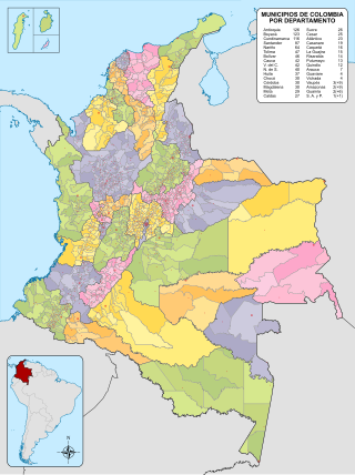
The municipalities of Colombia are decentralized subdivisions of the Republic of Colombia. Municipalities make up most of the departments of Colombia with 1,122 municipalities (municipios). Each one of them is led by a mayor (alcalde) elected by popular vote and represents the maximum executive government official at a municipality level under the mandate of the governor of their department which is a representative of all municipalities in the department; municipalities are grouped to form departments.

Ixtapaluca is a city and a municipality in the eastern part of the State of Mexico in Mexico. It lies between Mexico City and the western border of the state of Puebla. The name Ixtapaluca means "Where the salt gets wet".

The Triqui or Trique are an Indigenous people of the western part of the Mexican state of Oaxaca, centered in the municipalities of Juxtlahuaca, Putla, and Tlaxiaco. They number around 23,000 according to Ethnologue surveys. The Triqui language is a Mixtecan language of Oto-Manguean genetic affiliation. Trique peoples are known for their distinctive woven huipiles, baskets, and morrales (handbags).

San Juan Bautista Tuxtepec, or simply referred to as Tuxtepec, is the head of the municipality by the same name and is the second most populous city of the Mexican state of Oaxaca. It is part of the Tuxtepec District of the Papaloapan Region. As of the 2020 census, the city is home to a population of 103,609 and 159,452 in the municipality, though census data are often under reported for various reasons.

Jerécuaro is a Mexican city located in the lowlands of the state of Guanajuato. The municipality has an area of 828.3 square kilometres and is bordered to the north by Apaseo el Alto, to the east by Coroneo and the state of Querétaro, to the south by Tarandacuao, to the southwest with Acámbaro, and to the northwest with Tarimoro. The municipality had 55,311 inhabitants according to the 2005 census. The municipal president of Jerécuaro and its many smaller outlying communities is C.Jaime García Cardona.
Tlatlaya is one of 125 municipalities of the State of Mexico in Mexico. The municipal seat is the town of Tlatlaya which is the eleventh largest town in the municipality. The word “Tlatlaya” means when the hearth is black and red.
Huautla de Jimenez is a town and municipality in the Mexican state of Oaxaca. It is part of the Teotitlán District in the north of the Cañada Region.
San Jose Villa de Allende is a town and municipal seat of the municipality of Villa de Allende. It is the fifth largest town in the municipality. It is located 70 kilometers to the west of the city of Toluca. Villa de Allende was named in honor of Ignacio Allende, a hero of the Mexican War of Independence.
Tejupilco is a municipality in the State of Mexico, Mexico, located approximately 100 kilometres (62 mi) southwest of the state capital Toluca, along Federal Highway 134. Its municipal seat is Tejupilco de Hidalgo. The municipality has a total area of about 1,327 km2 (512 sq mi), with a contrasting topography ranging from deep ravines and canyons to high ridges; the highest elevation within the municipality reaches some 1,117 metres (3,660 ft) asl. The 2005 census recorded a population of 62,547 inhabitants.
Luvianos is a small town and municipality located in the southwest of the State of Mexico. It gained municipal status in 2000. People can access Luvianos by driving Federal Road 134 south from Toluca, and then take a detour about 25 minutes north of Tejupilco. The name is derived from a hacienda what was established during colonial times.

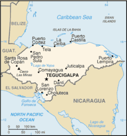
The following is an alphabetical list of topics related to the Republic of Honduras.

Santiago Papasquiaro is a municipality in the Mexican state of Durango. The municipal seat lies at Santiago Papasquiaro. The municipality covers an area of 7,238.4 km2. Santiago Papasquiaro municipality is at an average height of 1,730 m (5,675 ft) over the sea level. The municipality lies east of Sierra Madre Occidental Mountain Range. It neighbors with the municipalities of Canelas and Tepehuanes to the north, San Dimas and Otáez to the south, Nuevo Ideal to the east, Tamazula to the west and El Oro to the northeast.
The network of highways in Honduras is managed by the Secretariat of public works, transport and housing (SOPTRAVI), through the General Directorate of Roads, which is responsible for planning construction and maintenance work on the country's roads. Honduras has more than 15,400 kilometres (9,600 mi) of roads. Up to 1999, only 3,126 kilometres (1,942 mi) had been paved.

The Museum of Comayagua is an archaeological museum located in the city of Comayagua, Honduras, founded on June 6, 1940 and managed by the Honduran Institute of Anthropology and History. The museum has ten exhibition rooms and an archaeological theme of the history of the Comayagua Valley from ancient times to the present day. It is the only museum in the world dedicated to the Lenca culture. The museum is housed in a historic Spanish colonial house built in the late 16th century with a long history of use as the Presidential House of Honduras among many other important historical uses.