Las Piedras River (Peru)

Last updated
Las Piedras River
Río Tacuatimanu
Las Piedras River Outlook.jpg
Drone photo from lower Las Piedras River
Map of Las Piedras River and Pariamanu.png
Location
Country Peru
Physical characteristics
Mouth Madre de Dios River
Length640 km (400 mi) [1]

The Las Piedras River (the "River of Stones") is a major tributary of the Madre de Dios River in the southeast Peruvian Amazon. [2]

Contents

Geography of the Piedras Region

The Las Piedras River is located in the department of Madre de Dios, which is the official capital of biodiversity in Peru, [3] and is part of the Tropical Andes Biodiversity Hotspot. [4] The Tropical Andes Biodiversity Hotspot contains the largest percentage of endemic plants and animals in the world. [4] The Piedras is the longest tributary of the 1,347 km longMadre de Dios River and more than 99 percent of its drainage is in the Amazon lowlands, below 400 meters. [5] The capital of the Las Piedras District is the town of Planchón, which is located in the province Tambopata in the Madre de Dios Department [6]

Large portions of the headwaters of the Piedras River are protected by Alto Purus National Park. [7] Below Alto Purus on the Piedras River is the Reserva Territorial Madre de Dios, which is the official territory of Masco-Piro indigenous people, who have been living in voluntary isolation since at least the time of the rubber boom that began in the 1860s. [2] Downriver from the Reserva Territorial Madre de Dios are commercial timber concessions and the indigenous territories of Monte Salvado and Puerto Nuevo. Below the timber concessions and indigenous communities are Brazil nut concessions and several small indigenous and mestizo communities, including the mestizo communities of Lucerna and Sabaluyoc. [8] In this part of the Piedras River watershed, there are also several large private conservation-oriented concessions, including the Junglekeepers concession (20,234 hectares or 50,000 acres), which is a Peru-based non-profit, [9] the Las Piedras Amazon Center (LPAC) (4,460 hectares or 11,000 acres), run by the Peruvian nonprofit ARCAmazon, [8] the Arbio concession, run by Arbio Peru [10] and land protected by Hoja Nueva, which is a US-based nonprofit. [11]

History of the Piedras Region

Scarlet Macaws (Ara macao) at a clay lick Scarlet Macaw - IM.jpg
Scarlet Macaws (Ara macao) at a clay lick

The original indigenous name of the Piedras River is “Tacuatimanu”. [6] Indigenous communities in the region include the Masco-Piro, Amahuaca and the Yine. [2] In the first of many expeditions exploring the Piedras River, Father Pío Aza lead a group in 1911 to locate local indigenous groups and settle them in Christian missions. [2] The Masco-Piro and Amahuaca were exploited and enslaved by rubber barons starting during the rubber boom. The rubber boom arrived in the Las Piedras in 1894 after large concentrations of high-quality rubber were found. One of the most notable rubber barons in the Las Piedras area, was Carlos Scharff, who enslaved and exploited the local native populations to extract latex. [12] Members of the Masco-Piro living in voluntary isolation today are thought to be related to members of the Masco-Piro groups who fled local rubber barons before enslavement or after they attacked the rubber barons for being mistreated and later fled into the forests to avoid persecution. [2]

The Masco-Piro language is part of the Arawak and the Amahuaca is part of the Pano linguistic family. [2] The Masco-Piro live on the tributaries of the Manu, Los Amigos, Las Piedras, and Tahuamanu Rivers (Castillo 2004). These semi-nomadic groups are believed to move seasonally between the headwaters of the Manu, Alto Púrus, and Las Piedras rivers. [13] The Amahuca live in the community of Boca Pariamanu and in communities in isolation in the upper Piedras River. [2] The Yine live in the Monte Savado indigenous territory, which is on the border of the Reserva Territorial Madre de Dios. The Yine of Monte Salvado arrived from the Urubamba region of Peru around 1994. Members of the indigenous community of Monte Salvado and the nearby Puerto Nuevo were evacuated by the federal government in 2013 following the appearance of 200 armed indigenous men who raided the village. The raiders took blankets, machetes, rope, and food. It remains unclear what provoked the attack, but various proposals have been put forward, including increasing threats by drug traffickers and loggers and unusually cold weather related to recent climate change. [14]

The rubber boom in the Las Piedras River ended around 1912, [2] but in recent decades the Las Piedras has been host to other forms of resource extraction, including oil prospecting, several timber booms, and the paving of the nearby Interoceanic Highway. In 1996, the Mobil Oil was granted a 1,500,0000 ha concession to prospect for oil. The company eventually pulled out of the region after insufficient quantities of oil were found. [2] Logging of tropical hardwoods, particularly cedar and mahogany, has been a local commercial industry since the 1970s. The largest logging boom occurred in the 1990s due indirectly to international demand for mahogany and tropical cedar. In 2002, a study estimated there were 231 logging camps in the Piedras watershed with about 2,000 loggers operating in the area. [15] At the time, researchers recorded more than $5 million USD worth of wood traveling to the local market in Puerto Maldonado and that in one month the logging camps on the Piedras River consumed more than 2,000 mammals and more than 2,000 birds. They also estimated the monthly harvest of bushmeat during this period was around 41,000 kg. [15] During the logging boom of the 1990s and early 2000s, there were increased reports of loggers encountering uncontacted indigenous people, with 17% of loggers interviewed reporting contact with indigenous people living in voluntary isolation. [15]

Giant River Otter (Pteronura brasiliensis) Giant River Otter - IM.jpg
Giant River Otter (Pteronura brasiliensis)

Recent Land-Use Changes in the Middle Piedras River

More recently, the paving of the Interoceanic Highway has put increased pressure on the forests, wildlife, and indigenous communities of the Piedras region. The Interoceanic Highway was a $2.8 billion (USD) project that upgraded more than 20 bridges and thousands of kilometers of highway. These improvements now enable continuous road travel and the shipment of goods overland between ports in Brazil and ports in Peru. [16] The full effects of the highway have not yet been experienced, because the highway was only completed in 2011, but portions of the lower and middle Las Piedras are now under increased threat of deforestation. This conclusion is based on the fact that across the border in Acre, Brazil the paved highway affects the forests 45 km from the highway [17] and there are points where the lower and middle Piedras are within 30 km of the highway. In addition to logging, agriculture and ecotourism, Brazil nuts are a major industry in the Piedras watershed. Recent changes to forestry laws are thought to be affecting the increased amount of wood being harvested in Brazil nut concessions in Madre de Dios. [18]

Since 2013, the ecotourism concessions near the Las Piedras Amazon Center (LPAC) continue to experience deforestation, but LPAC has remained unaffected thanks to the efforts of the Peruvian NGO ARCAmazon. [19] The main threat to the forests around LPAC and the nearby community of Lucerna is forest clearing for cacao and cattle. [19] Since 2013, 605 hectares (1,490 acres) have been cleared, including 134 hectares (330 acres) in 2017. [19]

Peruvian spider monkey (Ateles chamek) Spider Monkey - FHW.jpg
Peruvian spider monkey (Ateles chamek)

Flora and Fauna

The Las Piedras watershed is home to many different animal and plant species. Among these are the endangered Peruvian spider monkey and giant river otter. Giant anteaters, jaguars, ocelots also have been spotted within the watershed.

The river is also home to clay licks, where birds and animals gather to consume sodium and other minerals.

Amazonian Royal Flycatcher (Onychorhynchus coronatus) Royal-Flycatcher - TA.jpg
Amazonian Royal Flycatcher (Onychorhynchus coronatus)

Tributaries of the Piedras River

· Ceticayo

· Chanchamayo

· Curiacu

· Huasca

· Panguana

· Pingachari

· Pumayacu

· Ronsoco

· Ronsoquito

· San Francisco

· Panguamayo

· Shahuana

· India

· Boleo

· Pariamanu

[15]

Representation in media

Related Research Articles

<span class="mw-page-title-main">Acre (state)</span> State of Brazil

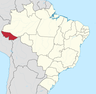
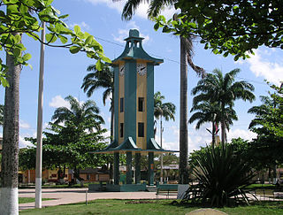
Acre ( ) is a state located in the west of the North Region of Brazil and the Amazonia Legal. Located in the westernmost part of the country, at a two-hour time difference from Brasília, Acre is bordered clockwise by the Brazilian states of Amazonas and Rondônia to the north and east, along with an international border with the Bolivian department of Pando to the southeast, and the Peruvian regions of Madre de Dios, Ucayali and Loreto to the south and west. Its capital and largest city is Rio Branco. Other important places include Cruzeiro do Sul, Sena Madureira, Tarauacá and Feijó. The state, which has 0.42% of the Brazilian population, generates 0.2% of the Brazilian GDP.

<span class="mw-page-title-main">Department of Madre de Dios</span> Departments of Peru

Madre de Dios is a department and region in southeastern Peru, bordering Brazil, Bolivia and the Peruvian departments of Puno, Cusco and Ucayali, in the Amazon Basin. Its capital is the city of Puerto Maldonado. It is also the third largest department in Peru, after Ucayali and Loreto. However, it is also the least densely populated department in Peru, as well as its least populous department. It has one of the lowest poverty rates in Peru.

<span class="mw-page-title-main">Madre de Dios River</span> River in Peru and Bolivia

The Madre de Dios River is a river shared by Bolivia and Peru which is homonymous to the Peruvian region it runs through. On Bolivian territory, it receives the Beni River, close to the town of Riberalta, which later joins with the Mamore River to become the Madeira River after the confluence. The Madeira is a tributary to the Amazon River.

<span class="mw-page-title-main">Manú River</span> River in Peru

The Manú is a river in southeastern Peru. It runs down the eastern slopes of the Andes Mountains into the Amazon Basin. It runs through what is now protected as the Manú National Park, a vast Biosphere Reserve, home to arguably the highest concentration of biodiversity on Earth. Few people live along its length. Much of the park is off-limits to all but permitted scientists and the indigenous groups of Amazonian Indians, mostly of the Machiguenga tribe.

<span class="mw-page-title-main">Puerto Maldonado</span> Place in Madre de Dios, Peru

Puerto Maldonado is a city in southeastern Peru in the Amazon rainforest 55 kilometres (34 mi) west of the Bolivian border, located at the confluence of the Tambopata and Madre de Dios rivers. The latter river joins the Madeira River as a tributary of the Amazon. This city is the capital of the Madre de Dios Region.

<span class="mw-page-title-main">Interoceanic Highway</span> Highway in Peru

The Interoceanic Highway or Trans-oceanic highway is an international, transcontinental highway in Peru and Brazil that connects the two countries. It was completed in 2011, and runs east to west, spanning 2,600 kilometres (1,600 mi).

The Amahuaca or Amhuaca are indigenous peoples of the southeastern Amazon Basin in Peru and Brazil. Isolated until the 18th century, they are currently under threat from ecological devastation, disease and violence brought by oil extractors and illegal loggers. In 1998, they numbered about 520. The largest community of the Amahuaca is in Puerto Varadero, a jungle community on the Peruvian–Brazilian border.

Piro is a Maipurean language spoken in Peru. It belongs to the Piro group which also includes Iñapari (†) and Apurinã. The principal variety is Yine. The Manchineri who live in Brazil (Acre) and reportedly also in Bolivia speak what may be a dialect of Yine. A vocabulary labeled Canamaré is "so close to Piro [Yine] as to count as Piro", but has been a cause of confusion with the unrelated Kanamarí language.

<span class="mw-page-title-main">La Convención Province</span> Province in Cusco, Peru

La Convención Province is the largest of thirteen provinces in the Cusco Region in the southern highlands of Peru.

<span class="mw-page-title-main">Peruvian Amazonia</span> Area of the Amazon rainforest

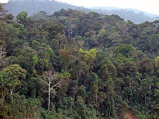
Peruvian Amazonia, informally known locally as the Peruvian jungle or just the jungle, is the area of the Amazon rainforest included within the country of Peru, from east of the Andes to the borders with Ecuador, Colombia, Brazil and Bolivia. This region comprises 60% of the country and is marked by a large degree of biodiversity. Peru has the second-largest portion of the Amazon rainforest after the Brazilian Amazon.

<span class="mw-page-title-main">Amazon rubber cycle</span> Historical period of Brazil (1879 to 1912)

The Amazon rubber cycle, or boom was an important part of the economic and social history of Brazil and Amazonian regions of neighboring countries, being related to the extraction and commercialization of rubber. Centered in the Amazon Basin, the boom resulted in a large expansion of colonization in the area, attracting immigrant workers, generating wealth, causing cultural and social transformations, and disrupting local indigenous societies.

The Mashco-Piro or Mascho Piro, also known as the Cujareño people and Nomole, are an indigenous tribe of nomadic hunter-gatherers who inhabit the remote regions of the Amazon rainforest. They live in Manú National Park in the Madre de Dios Region in Peru. They have in the past actively avoided contact with non-native peoples.

Alto Purús National Park is a national park in the Amazon rainforest of Peru, established in 2004. It covers an area of 2,510,694.41 ha (9,693.85 sq mi) in the provinces of Purús (Ucayali), Tahuamanu and Tambopata.

Las Piedras District is one of four districts of the province Tambopata in Peru. Bordered by the Rio Mavila on the northern boundary and the Rio Las Piedras to the south, the district comprises typical uninhabited lowland neotropical rainforest: Largely moist broadleaf evergreen or semi-evergreen with overstorey canopy and emergent crowns, medium layer canopy, lower canopy, shrub level and understory. The forest-structure is influenced by the flood regimes of the Las Piedras River, a highly meandering, white-water affluent of the Madre de Dios River.

<span class="mw-page-title-main">Tambopata River</span> River in Bolivia, Peru

The Tambopata River is a river in southeastern Peru and northwestern Bolivia. Most of the Tambopata is in the Madre de Dios and Puno regions in Peru, but the upper parts of the river forms the border between Peru and Bolivia, and its origin is in La Paz department in Bolivia. The Tambopata is a tributary of the Madre de Dios River, into which it merges at the city of Puerto Maldonado. The river flows through the Tambopata National Reserve.

<span class="mw-page-title-main">Carlos Fitzcarrald</span> Peruvian rubber baron

Carlos Fermín Fitzcarrald López was a Peruvian rubber baron. He was born in San Luis, Ancash. In the early 1890s he discovered the Isthmus of Fitzcarrald, which was a portage route that allowed transportation from the Ucayali River into the Madre de Dios River basin. He drowned in a river accident on the Urubamba River in 1897.

The Yine are an indigenous people in Peru. In the Cusco, Loreto, and Ucayali Departments, they live along the Urubamba River. They live along the Madre de Dios River in the Madre de Dios Department.

<span class="mw-page-title-main">Isthmus of Fitzcarrald</span> Historic site in Carlos Fermin Fitzcarrald Province, Peru

The Fitzcarrald Isthmus is an 11 km long land bridge that connected important rubber trade routes of the Urubamba River and the Madre de Dios River in Peru.

<span class="mw-page-title-main">Carlos Scharff</span> Rubber baron

Carlos Scharff was a Peruvian rubber baron of German descent who was active along the Upper Purus and Las Piedras rivers during the Amazon rubber boom in Peru. He also served for many years during his youth as an agent for the Belgian consulate in Brazil.

References

  1. Ziesler, R.; Ardizzone, G.D. (1979). "Amazon River System". The Inland waters of Latin America. Food and Agriculture Organization of the United Nations. ISBN   92-5-000780-9. Archived from the original on 21 October 2013.
  2. 1 2 3 4 5 6 7 8 9 Castillo, B.H (2004). Indigenous peoples in isolation in the Peruvian Amazon: Their struggle for survival and freedom. IWGIA.
  3. Scullion, Jason (2014). "Assessing the influence of land-cover change and conflicting land-use authorizations on ecosystem conversion on the forest frontier of Madre de Dios, Peru". Biological Conservation. 171: 247–258. doi:10.1016/j.biocon.2014.01.036.
  4. 1 2 Meyers, Norman. "2000". Nature. 403.6772: 853–858.
  5. Goulding, M. (2003). Amazon headwaters: Rivers, wildlife, and conservation in southeastern Peru. Amazon Conservation Association.
  6. 1 2 Santos, Kaway (2011). Madre De Dios, Puerto Maldonado, 1902-2002: Cien Años De Historia. Editorial Zignos.
  7. "Alto Purus in Peru". Protected Planet. 29 March 2018.
  8. 1 2 "Las Piedras River in Peru's Amazon Rainforest". 28 March 2018.
  9. "Junglekeepers". 7 August 2023.
  10. "Conservamos por Naturaleza. Arbio". 28 March 2018.
  11. "Hoja Nueva Home". 29 March 2018.
  12. Sociedad Geográfica de Lima 1917, p. 352-354.
  13. Fagan, C (2005). An investigation of illegal mahogany logging in Peru’s Alto Purús National Park and its surroundings. Durham NC: Parks Watch.
  14. "Peru evacuates Amazon village after raid by indigenous tribe". The Guardian. 23 December 2014. Retrieved 28 March 2018.
  15. 1 2 3 4 Schulte-Herbrüggen, B., & Rossiter, H. (2003). Project Las Piedras: a socio-ecological investigation into the impact of illegal logging activity in Las Piedras, Madre de Dios, Peru. Report, University of Edinburgh, Edinburgh, UK.
  16. "Traveling From Ocean to Ocean Across South America". The New York Times. 19 February 2014. Retrieved 28 March 2018.
  17. Southworth, J (2011). "Roads as Drivers of Change: Trajectories across the Tri‑National Frontier in MAP, the Southwestern Amazon". Remote Sensing. 3.5: 1047–1066. doi: 10.3390/rs3051047 .
  18. Cossío-Solano, R. E., Guariguata, M. R., Menton, M., Capella, J. L., Rios, L., & Peña, P. (2011). El aprovechamiento de madera en las concesiones casta eras (Bertholletia excelsa) en Madre de Dios, Per : Un análisis de su situación normativa (No. CIFOR Working Paper no. 56, p. 29p). Center for International Forestry Research (CIFOR), Bogor, Indonesia.
  19. 1 2 3 Finer, M (19 December 2017). "MAAP #75: Pope To Visit Madre De Dios, Region With Deforestation Crisis (Peru)". Monitoring of the Andean Amazon Project.

Bibliography

11°04′00″S71°46′00″W / 11.0667°S 71.7667°W / -11.0667; -71.7667