The Galápagos Islands are an archipelago of volcanic islands in the Eastern Pacific, located around the Equator 900 km (560 mi) west of South America. They form the Galápagos Province of the Republic of Ecuador, with a population of slightly over 33,000 (2020). The province is divided into the cantons of San Cristóbal, Santa Cruz, and Isabela, the three most populated islands in the chain. The Galápagos are famous for their large number of endemic species, which were studied by Charles Darwin in the 1830s and inspired his theory of evolution by means of natural selection. All of these islands are protected as part of Ecuador's Galápagos National Park and Marine Reserve.

Microlophus is a genus of tropidurid lizards native to South America. Around 20 species are recognized and 10 of these are endemic to the Galápagos Islands, where they are commonly known as lava lizards. The remaining, which often are called Pacific iguanas, are found in the Andes and along the Pacific coasts of Chile, Peru, and Ecuador.

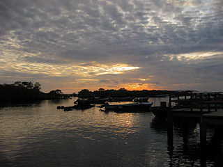
Puerto Baquerizo Moreno is the capital of Galápagos Province, Ecuador. It is located on the southwestern coast of San Cristóbal, the easternmost island in the archipelago, and is the capital of San Cristóbal Canton. It was founded by General Villamil Playas in the mid-19th century, and takes its name from President Alfredo Baquerizo (1859–1951). Today, fishing is the main activity of the locals, but tourism is on the increase along the waterfront with numerous hotels and shops.

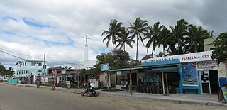
Puerto Ayora is a town in central Galápagos, Ecuador. Located on the southern shore of Santa Cruz Island, it is the seat of Santa Cruz Canton. The town is named in honor of Isidro Ayora, an Ecuadorian president. The town is sometimes mistakenly referred to as Santa Cruz. Puerto Ayora is the most populous town in the Galápagos Islands, with a population of 12,696.

San Cristóbal Island, also known as Chatham Island, is the easternmost island in the Galápagos archipelago, as well as one of the oldest geologically. It is administratively part of San Cristóbal Canton, Ecuador.
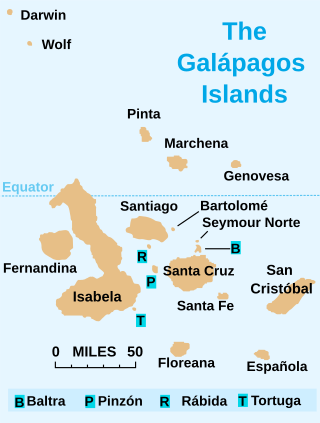
Isabela Island is the largest of the Galápagos Islands, with an area of 4,586 km2 (1,771 sq mi) and a length of 100 km (62 mi). By itself, it is larger than all the other islands in the chain combined and it has a little under 2000 permanent inhabitants. The island straddles the equator.
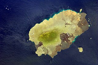
Santiago Island is one of the Galápagos Islands. The island, which consists of two overlapping volcanoes, has an area of 585 square kilometers (226 sq mi) and a maximum altitude of 907 meters (2,976 ft), atop the northwestern shield volcano. The volcano in the island's southeast erupted along a linear fissure and is much lower. The oldest lava flows on the island date back to 750,000 years ago.

Santa Cruz Island, also known as Indefatigable Island and by other names, is the most populous and second-largest island in the Galápagos Islands, Ecuador. Situated in the middle of the group, Santa Cruz is a shield volcano with an area of 986 km2 (381 sq mi) and a maximum altitude of 864 m (2,835 ft). The seat of Santa Cruz Canton is Puerto Ayora on Santa Cruz. The island's total population is around 18,000 with those living in smaller villages chiefly working in agriculture and cattle raising.

Baltra Island is a small island in the Galápagos Archipelago in Ecuador. It is a small flat island located near the center of the chain and includes Seymour Airport (GPS), originally established by the United States Air Force to help monitor and protect western access to the Panama Canal. Baltra is not part of the Galápagos National Park but some effort has been made to protect the local environment, including modernization of the airport and the reintroduction of the island's land iguanas.

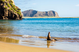
Española or Espanola Island is the most southerly of the Galápagos Islands in Ecuador, about a 10 to 12-hour trip by boat from Santa Cruz.
Santa Fe Island, also known as Barrington Island, is a small island of 24 square kilometres (9.3 sq mi) which lies in the middle of the Galápagos Archipelago in Ecuador. Visitor access is by a wet landing in Barrington Bay on the northeastern side of the island.

The Galápagos Marine Reserve (GMR) lies a thousand kilometres from the Ecuadorian mainland and covers an area of around 133,000 km2 (51,000 sq mi). The Galápagos Islands and the surrounding waters represent one of the world’s most unusual ecosystems and are rich areas of biodiversity. Recently granted UNESCO World Heritage Site status, the Galápagos Marine Reserve is the largest marine reserve in a developing country and the second largest reserve in the world.

Darwin Island is an isolated northern member of the Galápagos Islands in Ecuador, the uppermost extent of an extinct volcano. It has an area of 1 square kilometer (0.4 sq mi) and reaches 165 meters (541 ft) above sea level. Visits to the island are restricted by the Government of Ecuador, but scuba diving is permitted.
Isabela Canton is a canton of Galápagos Province, Ecuador, consisting of the islands of Isabela Island, Darwin, Fernandina, Wolf, and some minor islets. Isabela is the largest island in the Galápagos, and well known for its beaches, bays and coastal lagoons with a wide variety of plants and birds. The capital of the canton is Puerto Villamil.

North Seymour Island is a small island near Baltra Island in the Galápagos Islands in Ecuador. It was formed by uplift of a submarine lava formation and is now covered with low, bushy vegetation. It has an area of 1.9 km2 (0.73 sq mi) and a maximum elevation of 28 meters (92 ft). There is no permanent population but a visitor trail has been established approximately 2 km (1.2 mi) in length for guided tours crossing the interior of the island and exploring the rocky coast.
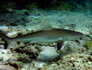
The Galapagos shark is a species of requiem shark, in the family Carcharhinidae, found worldwide. It favors clear reef environments around oceanic islands, where it is often the most abundant shark species. A large species that often reaches 3.0 m (9.8 ft), the Galapagos reef shark has a typical fusiform "reef shark" shape and is very difficult to distinguish from the dusky shark and the grey reef shark. An identifying character of this species is its tall first dorsal fin, which has a slightly rounded tip and originates over the rear tips of the pectoral fins.

José de Villamil or José Villamil (1789–1866) was born in New Orleans, when Louisiana was a colony of Spain. He was one of the fathers of the independence of Ecuador, founder of its navy, "conqueror" and first Governor of the Galápagos Islands and Minister of Foreign Relations. The city of General Villamil Playas is named in honor of him. José de Villamil was the younger brother of Felipe Martin de Villamil (1783–1843).
Puerto Villamil is a small port village located on the southeastern edge of Isla Isabela in the Galapagos Islands. Of the 2,200 people who live on Isabela, the majority live in Puerto Villamil. The harbor is frequently full with sailboats, as Villamil is a popular stop for private yachts making their way to the Marquesas Islands as it is the westernmost town in the Galapagos Islands. Puerto Villamil was founded in 1897 by Antonio Gil
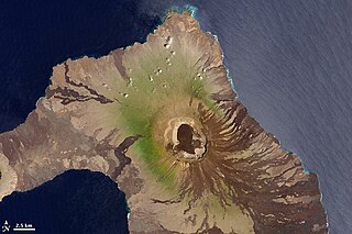
Wolf Volcano, also known as Mount Whiton, is the highest peak in the Galápagos Islands. It is situated on Isabela Island and reaches 1,710 m (5,610 ft). It is a shield volcano with a characteristic upturned soup bowl shape.

