The Galápagos Islands are an archipelago of volcanic islands in the Eastern Pacific, located around the equator, 900 km (560 mi) west of the mainland of South America. They form the Galápagos Province of the Republic of Ecuador, with a population of slightly over 33,000 (2020). The province is divided into the cantons of San Cristóbal, Santa Cruz, and Isabela, the three most populated islands in the chain. The Galápagos are famous for their large number of endemic species, which were studied by Charles Darwin in the 1830s and inspired his theory of evolution by means of natural selection. All of these islands are protected as part of Ecuador's Galápagos National Park and Marine Reserve.

The Pinta Island tortoise, also known as the Pinta giant tortoise, Abingdon Island tortoise, or Abingdon Island giant tortoise, is a recently extinct subspecies of Galápagos tortoise native to Ecuador's Pinta Island.

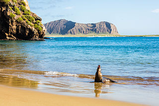
The Galápagos Islands xeric scrub, also known as the Galápagos Islands scrubland mosaic, is a terrestrial deserts and xeric shrublands ecoregion that covers the Galápagos Islands. The Galápagos Islands are volcanic in origin, and remote from continents and other islands. The ecoregion is well known for its unique endemic species, including giant tortoises, birds, and marine iguanas, which evolved in isolation to adapt to islands' environments.
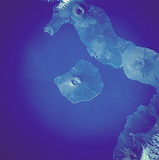
Fernandina Island is the youngest and third largest island in the Galapagos, as well as the furthest west. It has an area of 642 km2 (248 sq mi) and a height of 1,476 m (4,843 ft), with a summit caldera about 6.5 km (4.0 mi) wide. It is younger than Isabela, being only less than one million years old since its formation. Like the other islands, it was formed by the Galápagos hotspot. The island is an active shield volcano that has most recently erupted in March 2024.

Puerto Baquerizo Moreno is the capital of Galápagos Province, Ecuador. It is located on the southwestern coast of San Cristóbal, the easternmost island in the archipelago, and is the capital of San Cristóbal Canton. It was founded by General Villamil Playas in the mid-19th century, and takes its name from President Alfredo Baquerizo (1859–1951). Today, fishing is the main activity of the locals, but tourism is on the increase along the waterfront with numerous hotels and shops.

Puerto Ayora is a town in central Galápagos, Ecuador. Located on the southern shore of Santa Cruz Island, it is the seat of Santa Cruz Canton. The town is named in honor of Isidro Ayora, an Ecuadorian president. The town is sometimes mistakenly referred to as Santa Cruz. Puerto Ayora is the most populous town in the Galápagos Islands, with a population of 12,696.

San Cristóbal Island, also known as Chatham Island, is the easternmost island in the Galápagos archipelago, as well as one of the oldest geologically. It is administratively part of San Cristóbal Canton, Ecuador.

Sierra Negra is a large shield volcano at the southeastern end of Isabela Island in the Galapagos that rises to an altitude of 1124m. It coalesces with the volcanoes Cerro Azul to the west and Alcedo to the north. It is one of the most active of the Galapagos volcanoes with the most recent historic eruption beginning in June 2018 and continuing through the summer.
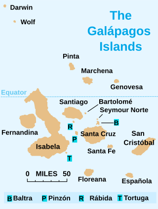
Isabela Island is the largest of the Galápagos Islands, with an area of 4,586 km2 (1,771 sq mi) and a length of 100 km (62 mi). By itself, it is larger than all the other islands in the chain combined, and it has a little under 2,000 permanent inhabitants. The island straddles the equator.

Santa Cruz Island, also known as Indefatigable Island and by other names, is the most populous and second-largest island in the Galápagos Islands, Ecuador. Situated in the middle of the group, Santa Cruz is a shield volcano with an area of 986 km2 (381 sq mi) and a maximum altitude of 864 m (2,835 ft). The seat of Santa Cruz Canton is Puerto Ayora on Santa Cruz. The island's total population is around 18,000 with those living in smaller villages chiefly working in agriculture and cattle raising.

Floreana Island is a southern island in Ecuador's Galápagos Archipelago. The island has an area of 173 km2 (67 sq mi). It was formed by volcanic eruption. The island's highest point is Cerro Pajas at 640 m (2,100 ft), which is also the highest point of the volcano like most of the smaller islands of Galápagos. The island has a population of about 100.

San Cristóbal Canton is a canton of Ecuador in the Galápagos Islands archipelago and one of the oldest in this insular geological formation. It consists of Española, Floreana, Genovesa, San Cristóbal, and Santa Fe Islands.
Isabela Canton is a canton of Galápagos Province, Ecuador, consisting of the islands of Isabela Island, Darwin, Fernandina, Wolf, and some minor islets. Isabela is the largest island in the Galápagos, and well known for its beaches, bays and coastal lagoons with a wide variety of plants and birds. The capital of the canton is Puerto Villamil.

Cerro Azul is a shield volcano on the south western part of Isabela Island in the Galápagos Islands. At a height of 1,689 m (5,541 ft) it is the second highest peak in the Galapagos and due to its topographic prominence of over 1,500 m (4,921 ft) it is categorised as an ultra. The volcano is one of the most active in the Galapagos, with the last eruption between May and June 2008.

Galápagos National Park was established in 1959. It began operation in 1968, and it is Ecuador's first national park and a UNESCO World Heritage Site.

The Galápagos tortoise or Galápagos giant tortoise is a very large species of tortoise in the genus Chelonoidis. The species comprises 15 subspecies. It is the largest living species of tortoise, and can weigh up to 417 kg (919 lb). They are also the largest extant terrestrial cold-blooded animals (ectotherms).
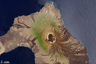
Wolf Volcano, also known as Mount Whiton, is the highest peak in the Galápagos Islands. It is situated on Isabela Island and reaches 1,710 m (5,610 ft). It is a shield volcano with a characteristic upturned soup bowl shape.
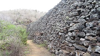
The Wall of Tears is a historical site 5 km west of Puerto Villamil on Isabela Island in the Galapagos Islands, Ecuador. It was constructed between 1945 and 1959 by prisoners in the penal colony on the island, which had been established by President José María Velasco Ibarra in 1944, using infrastructure left by the US military after World War II.
Las Tintoreras Islet (also called Tintorera or Villamil) is an islet to the south of the bay of Puerto Villamil in the island of Isabela, that forms part of the archipelago and national park of the Galapagos Islands, including administratively in the Province Of Galapagos. It is accessible by a boat trip where iguanas, boobies, penguins and seabirds can be observed.


