Related Research Articles

In aviation, instrument flight rules (IFR) is one of two sets of regulations governing all aspects of civil aviation aircraft operations; the other is visual flight rules (VFR).
A waypoint is an intermediate point or place on a route or line of travel, a stopping point or point at which course is changed, the first use of the term tracing to 1880. In modern terms, it most often refers to coordinates which specify one's position on the globe at the end of each "leg" (stage) of an air flight or sea passage, the generation and checking of which are generally done computationally.

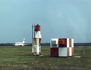
In aviation, the instrument landing system (ILS) is a precision radio navigation system that provides short-range guidance to aircraft to allow them to approach a runway at night or in bad weather. In its original form, it allows an aircraft to approach until it is 200 feet (61 m) over the ground, within a 1⁄2 mile (800 m) of the runway. At that point the runway should be visible to the pilot; if it is not, they perform a missed approach. Bringing the aircraft this close to the runway dramatically increases the range of weather conditions in which a safe landing can be made. Other versions of the system, or "categories", have further reduced the minimum altitudes, runway visual ranges (RVRs), and transmitter and monitoring configurations designed depending on the normal expected weather patterns and airport safety requirements.

An autopilot is a system used to control the path of an aircraft, marine craft or spacecraft without requiring constant manual control by a human operator. Autopilots do not replace human operators. Instead, the autopilot assists the operator's control of the vehicle, allowing the operator to focus on broader aspects of operations.

The Wide Area Augmentation System (WAAS) is an air navigation aid developed by the Federal Aviation Administration to augment the Global Positioning System (GPS), with the goal of improving its accuracy, integrity, and availability. Essentially, WAAS is intended to enable aircraft to rely on GPS for all phases of flight, including precision approaches to any airport within its coverage area. It may be further enhanced with the Local Area Augmentation System (LAAS) also known by the preferred ICAO term Ground-Based Augmentation System (GBAS) in critical areas.

In aviation, an instrument approach or instrument approach procedure (IAP) is a series of predetermined maneuvers for the orderly transfer of an aircraft operating under instrument flight rules from the beginning of the initial approach to a landing, or to a point from which a landing may be made visually. These approaches are approved in the European Union by EASA and the respective country authorities and in the United States by the FAA or the United States Department of Defense for the military. The ICAO defines an instrument approach as "a series of predetermined maneuvers by reference to flight instruments with specific protection from obstacles from the initial approach fix, or where applicable, from the beginning of a defined arrival route to a point from which a landing can be completed and thereafter, if landing is not completed, to a position at which holding or en route obstacle clearance criteria apply."

The Garmin G1000 is an electronic flight instrument system (EFIS) typically composed of two display units, one serving as a primary flight display, and one as a multi-function display. Manufactured by Garmin Aviation, it serves as a replacement for most conventional flight instruments and avionics. Introduced in June 2004, the system has since become one of the most popular integrated glass cockpit solutions for general aviation and business aircraft.
The microwave landing system (MLS) is an all-weather, precision radio guidance system intended to be installed at large airports to assist aircraft in landing, including 'blind landings'. MLS enables an approaching aircraft to determine when it is aligned with the destination runway and on the correct glidepath for a safe landing. MLS was intended to replace or supplement the instrument landing systems (ILS). MLS has a number of operational advantages over ILS, including a wider selection of channels to avoid interference with nearby installations, excellent performance in all weather, a small "footprint" at the airports, and wide vertical and horizontal "capture" angles that allowed approaches from wider areas around the airport.

A flight management system (FMS) is a fundamental component of a modern airliner's avionics. An FMS is a specialized computer system that automates a wide variety of in-flight tasks, reducing the workload on the flight crew to the point that modern civilian aircraft no longer carry flight engineers or navigators. A primary function is in-flight management of the flight plan. Using various sensors (such as GPS and INS often backed up by radio navigation) to determine the aircraft's position, the FMS can guide the aircraft along the flight plan. From the cockpit, the FMS is normally controlled through a Control Display Unit (CDU) which incorporates a small screen and keyboard or touchscreen. The FMS sends the flight plan for display to the Electronic Flight Instrument System (EFIS), Navigation Display (ND), or Multifunction Display (MFD). The FMS can be summarised as being a dual system consisting of the Flight Management Computer (FMC), CDU and a cross talk bus.
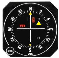
A course deviation indicator (CDI) is an avionics instrument used in aircraft navigation to determine an aircraft's lateral position in relation to a course to or from a radio navigation beacon. If the location of the aircraft is to the left of this course, the needle deflects to the right, and vice versa.
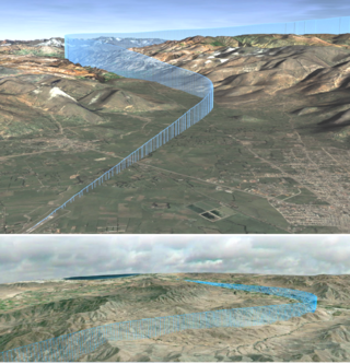
In aviation, vertical navigation is glidepath information provided during an instrument approach, independently of ground-based navigation aids in the context of an approach and a form of vertical guidance in the context of climb/descent. An onboard navigation system displays a constant rate descent path to minimums. The VNAV path is computed using aircraft performance, approach constraints, weather data, and aircraft weight. The approach path is computed from the top of descent point to the end of descent waypoint, which is typically the runway or missed approach point.
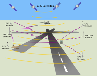
The local-area augmentation system (LAAS) is an all-weather aircraft landing system based on real-time differential correction of the GPS signal. Local reference receivers located around the airport send data to a central location at the airport. This data is used to formulate a correction message, which is then transmitted to users via a VHF Data Link. A receiver on an aircraft uses this information to correct GPS signals, which then provides a standard instrument landing system (ILS)-style display to use while flying a precision approach. The FAA has stopped using the term LAAS and has transitioned to the International Civil Aviation Organization (ICAO) terminology of ground-based augmentation system (GBAS). While the FAA has indefinitely delayed plans for federal GBAS acquisition, the system can be purchased by airports and installed as a Non-Federal navigation aid.
Required navigation performance (RNP) is a type of performance-based navigation (PBN) that allows an aircraft to fly a specific path between two 3D-defined points in space.

Area navigation is a method of instrument flight rules (IFR) navigation that allows an aircraft to choose any course within a network of navigation beacons, rather than navigate directly to and from the beacons. This can conserve flight distance, reduce congestion, and allow flights into airports without beacons. Area navigation used to be called "random navigation", hence the acronym RNAV.
In aviation, a flight director (FD) is a flight instrument that is overlaid on the attitude indicator that shows the pilot of an aircraft the attitude required to execute the desired flight path. Flight directors are mostly commonly used during approach and landing. They can be used with or without autopilot systems.
An equipment code describes the communication (COM), navigation (NAV), approach aids and surveillance transponder equipment on board an aircraft. These alphabetic codes are used on FAA and ICAO flight plan forms to aid Flight service station (FSS) personnel in their handling of aircraft.

Avidyne Entegra is an integrated aircraft instrumentation system, produced by Avidyne Corporation, consisting of a primary flight display (PFD), and multi-function display (MFD). Cirrus became the first customer of the Entegra system and began offering it on the SR20 and SR22 aircraft in 2003 as the first integrated flight deck for light general aviation (GA). The original Entegra system was designed to use third-party components such as a GPS from Garmin and an autopilot system from S-TEC Corporation.
L-3 SmartDeck - is a fully integrated cockpit system originally developed by L-3 Avionics Systems. and acquired in 2010 by Esterline CMC Electronics through an exclusive licensing agreement.
Localizer performance with vertical guidance (LPV) are the highest precision GPS aviation instrument approach procedures currently available without specialized aircrew training requirements, such as required navigation performance (RNP). Landing minima are usually similar to those of a Cat I instrument landing system (ILS), that is, a decision height of 200 feet (61 m) and visibility of 800 m. Lateral guidance is equivalent to a localizer, and uses a ground-independent electronic glide path. Thus, the decision altitude, DA, can be as low as 200 feet. An LPV approach is an approach with vertical guidance, APV, to distinguish it from a precision approach, PA, or a non-precision approach, NPA. WAAS criteria includes a vertical alarm limit more than 12 m, but less than 50 m, yet an LPV does not meet the ICAO Annex 10 precision approach standard.
ICAO performance-based navigation (PBN) specifies that aircraft required navigation performance (RNP) and area navigation (RNAV) systems performance requirements be defined in terms of accuracy, integrity, availability, continuity, and functionality required for the proposed operations in the context of a particular airspace, when supported by the appropriate navigation infrastructure.
References
- 1 2 Instrument Procedures Handbook, FAA-H-8083-16B (PDF). US Dept. of Transportation, FAA Flight Standards Service. 2017. p. 4-26,4-50, G-6.
- ↑ "RNAV, RNP, LNAV and VNAV Operations - Overview - Posts - Flaps 2 Approach". www.flaps2approach.com. Retrieved 28 May 2023.
| | This aviation-related article is a stub. You can help Wikipedia by expanding it. |