Related Research Articles

Taranto is a coastal city in Apulia, Southern Italy. It is the capital of the Province of Taranto and is an important commercial port as well as the main Italian naval base.
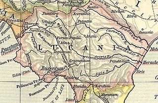
Lucania was a historical region of Southern Italy. It was the land of the Lucani, an Oscan people. It extended from the Tyrrhenian Sea to the Gulf of Taranto.

The Province of Caltanissetta is a province in the southern part of Sicily, Italy. Following the suppression of the Sicilian provinces, it was replaced in 2015 by the Free municipal consortium of Caltanissetta. It contains 22 comuni, which are listed at Comuni of the Province of Caltanissetta. Its coat of arms is a red crest and two green leaf stems on top with a laurel leaf on the right and a crown in the middle. The River Salso is the main river of the province; it is 122 kilometres (76 mi) long and originates in the province of Palermo, and it flows into the Mediterranean in this province at the end of the Gulf of Gela.
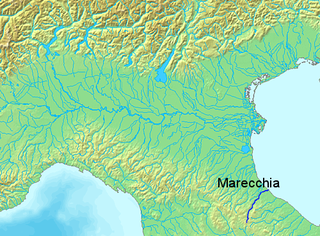
The Marecchia is a river in eastern Italy. In ancient times it was known as the Ariminus which was from the Greek Aríminos. The source of the river is near Monte dei Frati which is east of Pieve Santo Stefano and southwest of Badia Tedalda in the province of Arezzo in Tuscany. It flows northeast into the province of Pesaro and Urbino in the Marche and is the only river that runs through Montefeltro. While flowing through Montefeltro, the river flows through the exclave Santa Sofia Marecchia, which belongs to Badia Tedalda. The river then flows past Sant'Agata Feltria and Novafeltria before crossing into the province of Rimini in Emilia–Romagna. At Torello, part of the commune of San Leo, it flows 1 km west of the Sammarinese territory Acquaviva and the San Marino River flows into it, but the Marecchia does not touch the San Marino border. Finally, the river flows past Verucchio and Santarcangelo di Romagna before flowing into the Adriatic Sea near Rimini.

The Ofanto, known in ancient times as Aufidus or Canna, is a 170-kilometre (110 mi) river in southern Italy that flows through the regions of Campania, Basilicata, and Apulia, into the Gulf of Manfredonia near Barletta.

The Agri is a river in the Basilicata region of southern Italy. In ancient times it was known as Aciris. The source of the river is in the Lucan Apennines north of Monte Volturino and west of Calvello in the province of Potenza. It is near the source of the Basento. The river flows south near Paterno before curving southeast. It flows near Tramutola, Viggiano, and Grumento Nova before entering a lake. After exiting the lake, the river flows eastward near Armento, Missanello, Aliano, and Sant'Arcangelo. A right tributary, the Racanello, enters the river in this area. The river forms the border between the province of Potenza and the province of Matera for part of this area of the river. It flows into a small lake before entering the province of Matera. The river flows for a short distance before entering Lago di Gannano. After exiting the lake, the river flows southeast near Tursi, Montalbano Jonico, and Scanzano Jonico before flowing into the Gulf of Taranto near Policoro.
The Sinni is a 94 km long river in the Basilicata region of southern Italy. In antiquity, the city of Siris lay at its mouth. Near the town of Senise, a dam on the river was built in 1970-1982, the largest in Europe built with earth. In correspondence of it, it forms the Lake Monte Cotugno, one of the largest artificial basins in Italy.

The Basento is a river in the Basilicata region of southern Italy. It rises at Monte Arioso in the southern Apennine Mountains, southwest of Potenza in the province of Potenza. The river flows northeast near Pignola and Potenza before curving east near Vaglio Basilicata. It curves southeast and flows near Brindisi Montagna, Trivigno, and Albano di Lucania. A right tributary coming from Lago di Ponte Fontanelle flows into the river in this area. The river forms the border between the province of Potenza and the province of Matera for a short distance before flowing into the province of Matera. It flows eastward near Tricarico, Calciano, and Grassano before curving southeast. The river flows near Grottole, Miglionico, Pomarico, Ferrandina, and Monte Finese before curving eastward. It flows near Pisticci and Bernalda before flowing into the Gulf of Taranto, which is part of the Ionian Sea, near Metaponto. The main city on the Basento is Potenza, the capital of Basilicata.

Laterza is a town and comune in the province of Taranto, part of the Apulia region of southeast Italy.

The Agogna is a 140-kilometre (87 mi) stream which runs through the Italian regions of Piedmont and Lombardy. It is a left side tributary of the river Po.

The Montone is a river in the historical region of Romagna, which is in the present-day region of Emilia-Romagna in northern Italy. It is the northernmost river on the east-facing slopes of the Apennines to flow directly into the Adriatic Sea rather than entering the Po. Its Latin name was Utis or Vitis.

The Santerno is a river in Romagna in northern Italy. It is a major tributary of the river Reno. In Roman times, it was known as the Vatrenus, although, in the Tabula Peutingeriana, it was already identified as the Santernus.

The Cesano is a river in the Marche region of Italy. Its source is near Monte Catria on the border between the province of Perugia and the province of Pesaro e Urbino. The river flows northeast through Pesaro e Urbino before forming the border between Pesaro e Urbino and the province of Ancona for a short distance. It continues flowing northeast through Pesaro e Urbino and flows past Pergola before becoming the border with Ancona again near San Lorenzo in Campo. The river flows northeast near Mondavio, Corinaldo and Monte Porzio before the province of Ancona extends westward beyond the bank of the river for a short distance near Mondolfo. Finally, the river flows into the Adriatic Sea north of Senigallia and south of Marotta and Fano.

The Foglia is the northernmost river of the Marche region of Italy. In ancient times it was known as Pisaurus, as it debouched into the Adriatic Sea at Pisaurum. It was also known as the Isaurus. The source of the river is west of Sestino in the province of Arezzo in the Appennino Umbro-Marchigiano mountains. It flows east through an extension of the province of Pesaro e Urbino and then back into Arezzo before forming the border between Arezzo and Pesaro e Urbino. The river then flows into the province of Pesaro e Urbino past Piandimeleto and curves northeast and flows past Sassocorvaro before curving east again. The river meanders south of Montecalvo in Foglia before curving northeast and flowing near Colbordolo, Saludecio, Sant'Angelo in Lizzola, Montecchio, Montelabbate and Tavullia before entering the Adriatic Sea near Pesaro.

The Bidente-Ronco is a river in the Emilia-Romagna region of Italy. The first portion of the river is called the Bidente. Once the river passes under the Ponte dei Veneziani in Meldola, the river is called the Ronco. The source of the river is near the border between the province of Forlì-Cesena, the province of Arezzo, and the province of Florence in the Foreste Casentinesi, Monte Falterona, Campigna National Park. The river flows northeast through the mountains in the province of Forlì-Cesena and flows near Santa Sofia, Galeata, Civitella di Romagna and Meldola. Beyond Meldola, the river flows north near Bertinoro, Forlimpopoli, and Forlì before crossing the border into the province of Ravenna. The river flows northeast until it joins the Montone south of Ravenna, and the resulting river is known as the Uniti. The Battle of Ronco took place here.

The Chienti is a river in the Marche region of Italy. Its source is near Serravalle di Chienti in the Appennino Umbro-Marchigiano mountains in the province of Macerata. The river flows northeast through the mountains past Muccia and enters and exits a small reservoir before entering Lago di Pievefavera. After exiting Lago di Pievefavera, the river continues flowing northeast before being joined by the Fiastrone at Belforte del Chienti. The river continues flowing northeast past Tolentino before being joined by the Fiastra south of Macerata. The river flows east near Corridonia and forms the border between the province of Macerata and the province of Fermo before flowing into the Adriatic Sea near Civitanova Marche.
The Cavone is a river in the Basilicata region of southern Italy. It is 49 kilometres (30 mi) long, and has a drainage basin of 675 square kilometres (261 sq mi). Its source is west of Accettura in the province of Matera near the border with the province of Potenza. The river flows northeast near Oliveto Lucano and Garaguso before curving southeast. It flows near Salandra and San Mauro Forte before being joined by a right tributary. The river is joined by a left tributary north of Craco. It flows southeast near Pisticci and empties into the Gulf of Taranto.
The Bradano is a river in the Basilicata and Apulia regions of southern Italy. Its source is Lago Pesole in the province of Potenza. The river flows southeast near Monte Torretta, Acerenza, and Oppido Lucano. After crossing into the province of Matera, it is joined by a right tributary, the Alvo. The river flows near Irsina before being joined by a left tributary, the Basentello. Shortly after that, it is joined by another right tributary, the Bilioso. The river then enters Lago di San Giuliano. After flowing out of the lake, the Bradano is joined by a left tributary, the Gravina, and flows southeast near Montescaglioso before entering the province of Taranto. It is then joined by a left tributary, the Gravina di Matera, before re-entering the province of Matera after a short distance. The river flows near the border with the province of Taranto before entering the Gulf of Taranto near Lido di Metaponto.

The Gravina di Matera is a river in the Apulia and Basilicata regions of southern Italy. Its source is between Altamura and Gravina in Puglia in the province of Bari. The river flows southeast and curves east before again flowing southeast. It then flows into the province of Matera and is joined by a left tributary at Matera. The river forms the border between the province of Matera and the province of Taranto near Montescaglioso and Ginosa. Finally, it joins the Bradano as a left tributary in the province of Taranto.

Pane di Laterza is a traditional bread of Laterza, a little municipality in the province of Taranto, in Apulia, in Southeastern Italy. It is made with durum flour with water, salt and sourdough. It is mainly produced in Laterza, but it can be also found in neighbouring municipalities. It has been recognised by the Italian Ministry of the Agriculture, Food and Forestry Policies as Traditional Food Product of Apulia.
References
- ↑ The Times Comprehensive Atlas of the World (13 ed.). London: Times Books. 2011. p. 78 L3. ISBN 9780007419135.
| | This Apulia location article is a stub. You can help Wikipedia by expanding it. |