Latrun Interchange is a key road interchange of Israel, located between Jerusalem and Tel Aviv, at the intersection of Highway 1 and Highway 3. It is a slightly modified diamond interchange. The high speed ramps of westbound Highway 1 connect with Highway 3 at a traffic-light controlled junction. The high speed ramps of eastbound Highway 1 connect with Highway 3 at two offset, uncontrolled junctions. The interchange lies east of the Green Line within the Latrun Salient, technically part of the West Bank.
Israel, officially the State of Israel, is a country in Western Asia, located on the southeastern shore of the Mediterranean Sea and the northern shore of the Red Sea. It has land borders with Lebanon to the north, Syria to the northeast, Jordan on the east, the Palestinian territories of the West Bank and Gaza Strip to the east and west, respectively, and Egypt to the southwest. The country contains geographically diverse features within its relatively small area. Israel's economic and technological center is Tel Aviv, while its seat of government and proclaimed capital is Jerusalem, although the state's sovereignty over Jerusalem has only partial recognition.
Jerusalem is a city in the Middle East, located on a plateau in the Judaean Mountains between the Mediterranean and the Dead Sea. It is one of the oldest cities in the world, and is considered holy to the three major Abrahamic religions—Judaism, Christianity, and Islam. Both Israel and the Palestinian Authority claim Jerusalem as their capital, as Israel maintains its primary governmental institutions there and the State of Palestine ultimately foresees it as its seat of power; however, neither claim is widely recognized internationally.
Tel Aviv is the second most populous city in Israel—after Jerusalem—and the most populous city in the conurbation of Gush Dan, Israel's largest metropolitan area. Located on the country's Mediterranean coastline and with a population of 443,939, it is the economic and technological center of the country.
The name Latrun is ultimately derived from the ruins of a medieval castle. There are two theories regarding the origin of the name. One is that it is a corruption of the French, Le toron des chevaliers (The Castle of the Knights), named by the Crusaders. The other is that it is from the Latin, Domus bonu Latronis (The House of the Good Thief ), a name given by 14th century Christian pilgrims after the penitent thief who was crucified by the Romans alongside Jesus (Luke 23:40-43). [1]
The Crusades were a series of religious wars sanctioned by the Latin Church in the medieval period. The most commonly known Crusades are the campaigns in the Eastern Mediterranean aimed at recovering the Holy Land from Muslim rule, but the term "Crusades" is also applied to other church-sanctioned campaigns. These were fought for a variety of reasons including the suppression of paganism and heresy, the resolution of conflict among rival Roman Catholic groups, or for political and territorial advantage. At the time of the early Crusades the word did not exist, only becoming the leading descriptive term around 1760.
The Penitent Thief, also known as the Good Thief or the Thief on the Cross, is one of two unnamed persons mentioned in a version of the Crucifixion of Jesus in the New Testament. The Gospel of Luke describes one asking Jesus to "remember him" when Jesus will have "come into" his kingdom. The other, as the impenitent thief, challenges Jesus to save himself to prove that he is the Messiah.
Jesus, also referred to as Jesus of Nazareth and Jesus Christ, was a first-century Jewish preacher and religious leader. He is the central figure of Christianity, and is widely described as the most influential person in history. Most Christians believe he is the incarnation of God the Son and the awaited Messiah (Christ) prophesied in the Old Testament.
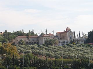
Adjacent to the castle ruins is the Latrun Monastery, founded in 1890 by Trappist monks dedicated to Our Lady of the Seven Sorrows. Opposite the monastery off of Highway 3 is Yad La-Shiryon, the Israel Armored Corps Memorial Site and Museum and Mini Israel, an Israel-themed miniature park.
Yad La-Shiryon is Israel's official memorial site for fallen soldiers from the armored corps, as well as one of the most diverse tank museums in the world. The cornerstone for Yad La-Shiryon was laid on December 14, 1982.
Mini Israel is a miniature park located near Latrun, Israel in the Ayalon Valley. Opened in November 2002, the site contains miniature replicas of hundreds of buildings and landmarks in Israel. The tourist attraction consists of about 350 large models of notable buildings. The scale of 1:25 produces skyscrapers that tower over an adult and historic churches taller than a child.
A miniature park is a display of miniature buildings and models, usually as a recreational and tourist attraction open to the public. A miniature park may contain a model of a single city or town, often called a miniature city or model village, or it can contain a number of different sets of models.
Directly east of the interchange on Highway 3 are the ruins of the ancient Roman city of Emmaus Nicopolis and the former site of Imwas, an Arab village which was destroyed as a result of the Six-Day War. Further east is the 7,000 dunam Ayalon-Canada Park.
In historiography, ancient Rome is Roman civilization from the founding of the Italian city of Rome in the 8th century BC to the collapse of the Western Roman Empire in the 5th century AD, encompassing the Roman Kingdom, Roman Republic and Roman Empire until the fall of the western empire. The civilization began as an Italic settlement in the Italian Peninsula, conventionally founded in 753 BC, that grew into the city of Rome and which subsequently gave its name to the empire over which it ruled and to the widespread civilisation the empire developed. The Roman Empire expanded to become one of the largest empires in the ancient world, though still ruled from the city, with an estimated 50 to 90 million inhabitants and covering 5.0 million square kilometres at its height in AD 117.
Emmaus Nicopolis (Greek: Ἀμμαοῦς)(Hebrew: אמאוס), was the Roman name for one of the towns associated with the Emmaus of the New Testament, where Jesus is said to have appeared after his death and resurrection. Emmaus was the seat of the Roman Emmaus, whereas Nicopolis was the name of the city from the 3rd century CE until the conquest of Palestine by the Muslim forces of the Rashidun Caliphate in 639. In the modern age, the site was the location of the Palestinian Arab village of Imwas, near the Latrun junction, between Jerusalem and Tel Aviv, before its destruction in 1967. The site today is inside Canada Park, a place maintained by the Israel Nature and Parks Authority, although the archaeological site has been cared for by a resident French Catholic community since 1993.
Imwas was a Palestinian Arab village located 12 kilometres (7.5 mi) southeast of the city of Ramla and 26 kilometres (16 mi) from Jerusalem in the Latrun salient of the West Bank. It is traditionally identified with the biblical Emmaus.
Latrun is located at a strategic hilltop in the Latrun salient in the Ayalon Valley. It overlooks the road between Tel Aviv and Jerusalem, 25 kilometers west of Jerusalem and 14 kilometers southeast of Ramla. It was the site of fierce fighting during the 1948 war. During the 1948–1967 period, it was occupied by Jordan at the edge of a no man's land between the armistice lines known as the Latrun salient. In the 1967 war, it was captured by Israel along with the whole salient and the West Bank, and remains a part of Israel to this day.
The Conestoga Parkway is a freeway in the Regional Municipality of Waterloo, in the Canadian province of Ontario. It runs northeast/southwest through the cities of Kitchener and Waterloo, and is connected to Highway 401 via the Highway 8 Freeport Diversion and King Street East. The name "Conestoga Parkway" is not a formal designation, but rather a local name applied to the divided expressway portions of Highway 7, Highway 8 and Highway 85 through Kitchener and Waterloo. When the parkway opened in the late 1960s there were a few large green and white signs reading "Conestoga Parkway" with a picture of a Conestoga wagon on them located along the parkway. By the 1990s after several sections of the parkway had undergone reconstruction and expansion, these signs had been removed but many maps still show this as the name of the freeway. Most residents of Kitchener and Waterloo refer to the parkway as "The Expressway". By contrast, the portion of Highway 8 which departs from the parkway at King Street East in Kitchener and runs to Highway 401 is often referred to as "The Highway 8 Expressway" by local residents.
A cloverleaf interchange is a two-level interchange in which left turns are handled by ramp roads. To go left, vehicles first continue as one road passes over or under the other, then exit right onto a one-way three-fourths loop ramp (270°) and merge onto the intersecting road. The objective of a cloverleaf is to allow two highways to cross without the need for any traffic to be stopped by red lights, even for left and right turns. The limiting factor in the capacity of a cloverleaf interchange is traffic weaving.
The Megiddo Junction is an intersection of Highways 65 and 66 in northern Israel, at the exit from the mountain pass coming up through Wadi Ara into the Jezreel Valley. It is named for the nearby ruins of the biblical city of Megiddo, also known as Armageddon, and the sites of several historic battles. Adjacent to the junction is the large Megiddo Prison, and less than a kilometre to the northwest is kibbutz Megiddo.
Grade separation is a method of aligning a junction of two or more surface transport axes at different heights (grades) so that they will not disrupt the traffic flow on other transit routes when they cross each other. The composition of such transport axes does not have to be uniform; it can consist of a mixture of roads, footpaths, railways, canals, or airport runways. Bridges, tunnels, or a combination of both can be built at a junction to achieve the needed grade separation.
A diamond interchange is a common type of road junction, used where a freeway crosses a minor road.
In the field of road transport, an interchange is a road junction that uses grade separation, and typically one or more ramps, to permit traffic on at least one highway to pass through the junction without interruption from other crossing traffic streams. It differs from a standard intersection, where roads cross at grade. Interchanges are almost always used when at least one road is a controlled-access highway or a limited-access divided highway (expressway), though they are sometimes used at junctions between surface streets.
A stack interchange, or colloquially butterfly junction, is a particular, free-flowing type of design for interchanges, meaning grade-separated road junctions. It is referred to as a directional interchange in the American Association of State Highway and Transportation Officials Policy on Geometric Design of Highways and Streets.
Highway 1, is the main highway connecting Tel Aviv and Jerusalem in Israel and continuing eastwards to the Jordan Valley.
Modi'in-Maccabim-Re'ut is an Israeli city located in central Israel, about 35 kilometres (22 mi) southeast of Tel Aviv and 30 kilometres (19 mi) west of Jerusalem, and is connected to those two cities via Highway 443. In 2017 the population was 91,328. The population density in that year was 1,794 people per square kilometer.
Highway 50, officially called Begin Boulevard and also referred to as Menachem Begin Expressway or Begin Highway, is an urban freeway in western Jerusalem named after Israel's sixth Prime Minister, Menachem Begin. Local Jerusalemites simply refer to it as 'Begin'. It continues into the Palestinian territories.
Route 443 is also known as Ma'ale Beit Horon, following the ancient east-west trade route connecting the Via Maris and the Way of the Patriarchs. It is the main highway connecting Tel Aviv and Gush Dan with Jerusalem via Modi'in. While technically listed as a regional road, it is for the most part a divided, four-lane highway which utilises some grade separation and interchanges, as well as major at-grade intersections, and thus is not classified as a motorway, even though there is a short motorway section on its western end, connecting it to westbound Highway 1.
Interstate 15 (I-15) runs north–south in the U.S. state of Utah through the southwestern and central portions of the state, passing through many of the population centers of the state, including St. George, Provo, Salt Lake City, and Ogden, the latter three being part of the urban area known as the Wasatch Front. It is the primary north–south highway in Utah, as the majority of the state's population lives along its corridor. The only Metropolitan Statistical Area in Utah not connected by I-15 is the Logan Utah-Idaho Metropolitan Statistical Area. In 1998, the Utah Legislature designated the entire length within Utah as the Veterans Memorial Highway.
Highway 3 is a highway in Israel. It begins at Highway 4 on the outskirts of Ashkelon, running east-northeast, passing through Kiryat Malakhi and Latrun, and ending just short of Modi'in.
Highway 7 is a highway in the South District of Israel from Ashdod to Yesodot. It connects the Port of Ashdod with the Trans-Israel Highway.
Highway 38 is an arterial road in the low plains of Judea in Israel. It serves as the main access route to Beit Shemesh and as a main north-south route in the region. Along the route are many nature preserves and archeological sites.
Highway 41 is an arterial road in south-central Israel. It connects Highway 4 and Highway 7 to the Port of Ashdod. The designation "41" also applied to the continuation of the road eastward to Gedera until that section of the road was upgraded and renamed "7".
Highway 44 is an arterial road in central Israel. It connects Tel Aviv-Yafo and Holon to Ramla, Lod and the Shefela.

Terminology related to road transport—the transport of passengers or goods on paved routes between places—is diverse, with variation between dialects of English. There may also be regional differences within a single country, and some terms differ based on the side of the road traffic drives on. This glossary is an alphabetical listing of road transport terms.
Coordinates: 31°50′21.2″N34°59′13.7″E / 31.839222°N 34.987139°E
A geographic coordinate system is a coordinate system that enables every location on Earth to be specified by a set of numbers, letters or symbols. The coordinates are often chosen such that one of the numbers represents a vertical position and two or three of the numbers represent a horizontal position; alternatively, a geographic position may be expressed in a combined three-dimensional Cartesian vector. A common choice of coordinates is latitude, longitude and elevation. To specify a location on a plane requires a map projection.