
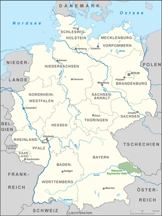
The Bavarian Forest is a wooded, low-mountain region in Bavaria, Germany, that is about 100 kilometres long. It runs along the Czech border and is continued on the Czech side by the Bohemian Forest. Most of the Bavarian Forest lies within the province of Lower Bavaria, but the northern part lies within the Upper Palatinate. In the south it reaches the border with Upper Austria.

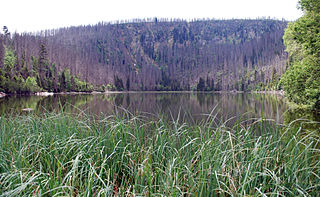
The Bavarian Forest National Park is a national park in the Eastern Bavarian Forest immediately on Germany's border with the Czech Republic. It was founded on 7 October 1970 as the first national park in Germany. Since its expansion on 1 August 1997 it has covered an area of 24,250 hectares. Together with the neighbouring Czech Bohemian Forest the Bavarian Forest forms the largest contiguous area of forest in Central Europe.

The Bavarian Alps is a collective name for several mountain ranges of the Northern Limestone Alps within the German state of Bavaria.

The Bohemian Forest, known in Czech as Šumava and in German as Böhmerwald, is a low mountain range in Central Europe. Geographically, the mountains extend from Plzeň Region and the South Bohemian Region in the Czech Republic to Austria and Bavaria in Germany, and form the highest truncated uplands of the Bohemian Massif, up to 50 km wide. They create a natural border between the Czech Republic on one side and Austria and Germany on the other.

Bayerisch Eisenstein, until 1951 just Eisenstein is a village and a municipality in the Regen district, in Bavaria, Germany.

Rimbach is a municipality in the district of Cham (district) in the Upper Palatinate in Bavaria in Germany.
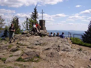
The Großer Arber ; Czech: Velký Javor, "Great Maple") or Great Arber, is the highest peak of the Bavarian/Bohemian Forest mountain range and in Lower Bavaria, with an elevation of 1,455.5 metres (4,775 ft). As a result, it is known in the Lower Bavarian county of Regen and the Upper Palatine county of Cham as the "King of the Bavarian Forest". Its summit region consists of paragneiss.

Lusen is a 320 million years old granite mountain located in Bavaria (Germany), being the highest one in the district Freyung-Grafenau with a peak of 1373 metres. It is the sixth-highest mountain in the Bavarian Forest National Park/Bohemian Forest, behind the Großer Rachel, Kleiner Rachel, Kleiner Arber, Plattenhausenriegel and Großer Arber. It's location is south of the Czech Republic–Germany border. The mountain itself is located in the Bavarian Forest National Park and streams forming on the north side become tributaries of the Vydra.
The Botanischer Garten der Nationalpark Bayerischer Wald is a botanical garden located adjacent to the Hans-Eisenmann-Haus visitor center in the Nationalpark Bayerischer Wald at Böhmstraße 35, Neuschönau, Bavaria, Germany. The garden contains over 700 plant species found in the Bavarian Forest, in habitats ranging from meadows, slopes, and rock fields, to springs, ponds, and bogs. It also includes geological displays.

The Einödriegel is a mountain, 1,120.6 m above sea level (NHN), in the Bavarian Forest in Germany. It rises southwest of the Lower Bavarian county town of Regen and northeast of the county town of Deggendorf. It is the highest point in the Danube Hills and the county of Deggendorf and lies in the municipality of Grafling.
The Großer Falkenstein or Great Falkenstein, is a mountain, 1,315 metres (4,314 ft) high, in the Bavarian Forest about five kilometres southeast of Bayerisch Eisenstein in the Falkenstein-Rachel region of the Bavarian Forest National Park.
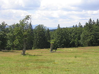
Schachten (singul.) are ancient areas of pasture in the Bavarian Forest in Germany, some of which are still used today.

On 8 March 1988 the Bavarian State Ministry for State Development and the Environment designated an area of 1,280 square kilometres (490 sq mi) in the Steigerwald in North Bavaria, Germany, as the Steigerwald Nature Park. About half the area consists of protected landscapes. The nature park is run by the Steigerwald Tourist Association and Steigerwald Nature Park.

The Schwandorf–Furth im Wald railway is a 67 km long mainline railway in the German state of Bavaria. It runs from Schwandorf via Cham to Furth im Wald. It is part of a long-distance connection between Germany and the Czech Republic.
The Anterior Bavarian Forest, also variously called the Vorderer Forest, Vorderer Wald or Danube Hills, is part of the Bavarian Forest, a low mountain range in Germany.
The Bavarian Forest Nature Park covers an area north of the Danube as far as the border ridge with the Czech Republic. Its sponsor organisation is the Naturpark Bayerischer Wald whose head office is in Zwiesel, Bavaria. It was established in 1967 and is thus the oldest nature park in Bavaria.

The Bavarian Forest Club, or BWV, is a German club that promotes culture, local history and folklore, nature and landscape conservation, and walking in the Bavarian Forest. It has its head office in Zwiesel and is registered in the register of clubs and societies in the district office at Deggendorf.

The Upper Bavarian Forest Nature Park covers an area of 1,796 km2 and is thus one of the largest nature parks in the German state of Bavaria.
The Plöckenstein is a mountain, 1,379 m (AA) high, in the Bohemian Forest on the Austro-Czech border. Its summit is the highest point in the Bohemian Forest in both countries, and also the highest point in the regions of Mühlviertel and South Bohemia. It is well known as a result of stories by Adalbert Stifter.

The Bavarian Forest Museum Village is an open air museum near Tittling on the southwestern shore of the Dreiburgensee lake in the Bavarian Forest. It covers about 25 hectares and has over 150 buildings from the period from 1580 to 1850 and a local history collection with 60,000 items. It is thus one of the largest open air museums in Europe.

