Related Research Articles

The Stillwater River is a 69.3-mile-long (111.5 km) tributary of the Great Miami River in western Ohio in the United States. Via the Great Miami and Ohio rivers, it is part of the Mississippi River watershed.

Little Beaver Creek is a wild and scenic area in Ohio. The Little Beaver Creek watershed is located primarily in Columbiana County in eastern Ohio, and in portions of Carroll County, Mahoning County, and western Pennsylvania, draining approximately 605 mi² (1,567 km²), of which 503 mi² (1,303 km²) are in Ohio. The watershed in total size covers an area of approximately 510 square miles, with about 80% of this being situated in Ohio. The great majority of land within the watershed is privately owned. Within the watershed are roughly 808 miles of linear streams.

The Conasauga River is a river that runs through southeast Tennessee and northwest Georgia. The Conasauga River is 93 miles (150 km) long and drains into the Oostanaula River, a tributary of the Coosa River and part of the watershed of the Gulf of Mexico. The river is home to over 90 species of fish and 25 surviving species of freshwater mussels. Its watershed encompasses over 500,000 acres (2,000 km2) in two states, multiple counties, and two ecologically different regions.

Big Walnut Creek starts near Mount Gilead, Ohio in Morrow County. It flows south to eastern Delaware County and parallels Alum Creek. It passes to the east of Sunbury and into Hoover Reservoir, which then crosses into Franklin County. From the dam outflow in Westerville the creek flows through Gahanna and Whitehall. Near Obetz it is joined by its principal tributaries Alum Creek and Blacklick Creek at the Three Creeks Columbus Metro Park. It flows through southern Franklin County and joins the Scioto River near the Franklin-Pickaway Counties line at 39°47′57″N83°00′34″W.
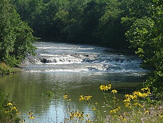
Greenville Creek is a 44.4-mile-long (71.5 km) tributary of the Stillwater River in southwestern Ohio in the United States. Via the Stillwater River, the Great Miami River, and the Ohio River, its water flows to the Mississippi River and ultimately the Gulf of Mexico. The creek starts in extreme eastern Indiana in Randolph County. It soon flows into Darke County, Ohio, and joins with a tributary that also starts in Indiana, Dismal Creek. It flows through Greenville and Gettysburg before entering Miami County. Near its confluence with the Stillwater River at Covington it drops 20 feet (6.1 m) at Greenville Falls in a glacially-cut gorge that is a state nature preserve.

Little Fishing Creek is a tributary of Fishing Creek in Sullivan County, Lycoming County, and Columbia County, in Pennsylvania, in the United States. It is approximately 23.5 miles (37.8 km) long and flows through eight townships. The watershed of the creek has an area of 68.1 square miles (176 km2). The creek has six named tributaries, of which the largest are Spruce Run and West Branch Run.

The Little Schuylkill River is a 30.6-mile-long (49.2 km) tributary of the Schuylkill River in Northeastern Pennsylvania.

A "quadrangle" is a topographic map produced by the United States Geological Survey (USGS) covering the United States. The maps are usually named after local physiographic features. The shorthand "quad" is also used, especially with the name of the map; for example, "the Ranger Creek, Texas quad". A quadrangle is defined by north and south boundaries of constant latitude, and by east and west boundaries of constant longitude.

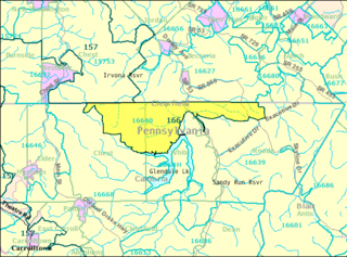
Sandy Run is a second-order stream that is a tributary to the Wissahickon Creek at Fort Washington State Park. The headwaters are in Dresher and Roslyn, Pennsylvania, and the stream flows west for approximately 6 miles (9.7 km). The stream follows through Abington, Upper Dublin, Springfield, and Whitemarsh Townships; and flows through several golf courses, including Sandy Run Country Club, Lu Lu Country Club, and Manufacturers Country Club. This creek can be fished in some places, mainly between Manufacturer's Country Club and the Wissahickon Creek. Fish that inhabit this creek include Sunfish, Carp, Smallmouth and Largemouth Bass, Catfish, and several other species.
Antietam Creek is a 10.5-mile-long (16.9 km) tributary of the Schuylkill River in Berks County, Pennsylvania. It rises just south of Alsace Manor in Alsace Township. There are several non-named tributaries to the creek. It empties into the Schuylkill just south of Reading.

The Turtle River is a 17.6-mile-long (28.3 km) tidal river in the vicinity of Brunswick in Glynn County, Georgia. It is the main tributary of the Brunswick River.
Flinton is a village and an unincorporated community in Cambria County, Pennsylvania, United States. Flinton has a post office with ZIP code 16640.

Pisgah Mountain, or Pisgah Ridge on older USGS maps, is a ridgeline running 12.5 miles (20.1 km) from Tamaqua to Jim Thorpe, Pennsylvania from the Little Schuylkill River water gap to the Lehigh River water gap.
Hemlock Run is a tributary of West Branch Fishing Creek in Sullivan County, Pennsylvania, in the United States. It is approximately 1.8 miles (2.9 km) long and flows through Davidson Township. The stream has three unnamed tributaries. Its watershed has an area of 1.28 square miles (3.3 km2). Wisconsinan Till Moraine, Wisconsinan Bouldery Till, Wisconsinan Flow-Till, and Wisconsinan Till all occur near the stream.
Laurel Run is a tributary of West Branch Fishing Creek in Sullivan County, Pennsylvania, in the United States. It is approximately 1.2 miles (1.9 km) long and flows through Davidson Township. The stream is in the United States Geological Survey quadrangle of Elk Grove. Wisconsinan Flow-Till, Boulder Colluvium, Wisconsinan Till Moraine, alluvium, and alluvial fan occur in the vicinity of the stream, as does bedrock consisting of sandstone and shale. The southern terminus of the late Wisconsinan glaciation is also in the area. A wood plank bridge on stone masonry abutment walls crosses the stream.

Laurel Run is a tributary of Huntington Creek, in Luzerne County, Pennsylvania, in the United States. It is approximately 1.8 miles (2.9 km) long and flows through Ross Township. The watershed of the stream has an area of 1.29 square miles (3.3 km2). Wild trout naturally reproduce in the stream. The surficial geology in the area mainly consists of Wisconsinan Till, Wisconsinan Ice-Contact Stratified Drift, and bedrock consisting of sandstone and shale. The stream is designated as a Least Disturbed Stream.
Tunis Run is a tributary of White Deer Creek in Centre County, Pennsylvania, in the United States. It is approximately 1.5 miles (2.4 km) long and flows through Miles Township. The watershed of the stream has an area of 1.43 square miles (3.7 km2). The stream is situated near Hough Gap and a railroad was once built near it. Wild trout naturally reproduce within it.
Doe Run Creek is a stream in St. Francois County in the U.S. state of Missouri. It is a tributary of the St. Francis River.
Laurel Run is a tributary of Little Muncy Creek in Columbia County and Lycoming County, in Pennsylvania, in the United States. It is approximately 6.8 miles (10.9 km) long and flows through Madison Township and Pine Township in Columbia County and Franklin Township and Moreland Township in Lycoming County. The watershed of the stream has an area of 12.2 square miles (32 km2). It is classified as a Coldwater Fishery and a Migratory Fishery. A number of bridges have been constructed over the stream.
The Podunk River is a stream in Hartford County, Connecticut. It is a tributary to the Connecticut River.