Lavon Dam

Last updated
Lavon Dam
USACE Lavon Lake and Dam.jpg
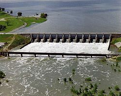
Aerial view of Lavon Dam
CountryUnited States
Location Collin County, Texas
Coordinates 33°1′57″N96°28′2″W / 33.03250°N 96.46722°W / 33.03250; -96.46722 Coordinates: 33°1′57″N96°28′2″W / 33.03250°N 96.46722°W / 33.03250; -96.46722
StatusIn use
Construction beganJanuary, 1948
Opening dateSeptember, 1953 (September, 1953)
Construction cost$88,351,248.00
Owner(s)The U.S. government, operated by the U.S. Army Corps of Engineers, Fort Worth District
Dam and spillways
Type of dam Rolled earthfill
ImpoundsEast Fork of the Trinity River
Height81 ft (25 m)
Length19,493 ft (5,941 m)
Width (crest)475.5 ft (144.9 m)
Dam volume17,055,000 cu yd (13,039,000 m3)
Spillway type Ogee crest
Spillway capacity1,507,000 cu ft/s (42,700 m3/s)
Reservoir
Creates Lavon Reservoir
Total capacity409,360 acre⋅ft (0.50494 km3)
Surface area20,559 acres (8,320 ha)

Lavon Dam is located in Collin County, Texas on the East Fork [1] of the Trinity River, about 3 miles east of Wylie and 22 miles northeast of Dallas. It was constructed to create the Lavon Lake and is named after the town of Lavon. Dams are generally named after the closest town near the structure. [2]

Contents

History

Construction on the Lavon Dam began in January, 1948, and was completed in March, 1953. Deliberate impoundment began on September 14, 1953. The cost of the project was $18,554,570. On May 15, 1970, construction began on a modification of Lavon Dam that increased the conservation storage pool from elevation 472.0 feet to the current elevation of 492.0 feet by raising the top of the dam 12 feet. The modification was completed and deliberate impoundment began December 1, 1975. The cost of the modification was $69,796,678, which brought the grand total cost to $88,351,248. [2]

Related Research Articles

Trinity River (Texas) River in Texas, United States

The Trinity River is a 710-mile-long (1,140 km) river in Texas, and is the longest river with a watershed entirely within the U.S. state of Texas. It rises in extreme northern Texas, a few miles south of the Red River. The headwaters are separated by the high bluffs on the southern side of the Red River.

Roanoke River River in Virginia and North Carolina, United States

The Roanoke River is a river in southern Virginia and northeastern North Carolina in the United States, 410 miles (660 km) long. A major river of the southeastern United States, it drains a largely rural area of the coastal plain from the eastern edge of the Appalachian Mountains southeast across the Piedmont to Albemarle Sound. An important river throughout the history of the United States, it was the site of early settlement in the Virginia Colony and the Carolina Colony. An 81-mile (130 km) section of its lower course in Virginia between the Leesville Lake and Kerr Lake is known as the Staunton River, pronounced, as is the Shenandoah Valley city of that name. It is impounded along much of its middle course to form a chain of reservoirs.

John Day Dam Dam in Sherman County, Oregon / Klickitat County, WashingtonUnited States

The John Day Dam is a concrete gravity run-of-the-river dam spanning the Columbia River in the northwestern United States. The dam features a navigation lock plus fish ladders on both sides. The John Day Lock has the highest lift (110 feet) of any U.S. lock. The reservoir impounded by the dam is Lake Umatilla, and it runs 76.4 miles up the river channel to the foot of the McNary Dam. John Day Dam is part of the Columbia River Basin system of dams.

Lake Cumberland Man-made reservoir in Kentucky, United States

Lake Cumberland is a reservoir in Clinton, Laurel, McCreary, Pulaski, Russell, and Wayne counties in Kentucky. The primary reasons for its construction were a means for flood control and the production of hydroelectric power. Its shoreline measures 1,255 miles (2,020 km) and the lake covers 65,530 acres (265 km2) at the maximum power pool elevation. The reservoir ranks 9th in the U.S. in size, with a capacity of 6,100,000 acre feet (7.5 km3) of water, enough to cover the entire Commonwealth of Kentucky with 3 inches (76 mm) of water. The main lake is 101 miles (163 km) long and over one mile (1.6 km) across at its widest point.

Lewisville Lake Reservoir in Texas, United States

Lewisville Lake is a reservoir in North Texas (USA) on the Elm Fork of the Trinity River in Denton County near Lewisville. Originally engineered in 1927 as Lake Dallas, the reservoir was expanded in the 1940s and 1950s and renamed Lewisville Lake. It was built for flood control purposes and to serve as a water source for Dallas and its suburbs, but residents also use it for recreational purposes.

Lake Ray Hubbard, formerly Forney Lake, is a fresh water impoundment (reservoir) located in Dallas, Texas in the counties of Dallas, Kaufman, Collin, and Rockwall just north of the City of Forney. It was created by the construction of the Rockwall-Forney Dam which impounded the East Fork Trinity River.

Wheeler Dam Dam in Lauderdale / Lawrence counties, Alabama, United State

Wheeler Dam is a hydroelectric dam on the Tennessee River between Lauderdale County and Lawrence County in Alabama. It is one of nine dams on the river owned and operated by the Tennessee Valley Authority, which built the dam in the mid-1930s as part of a New Deal-era initiative to improve navigation on the river and bring flood control and economic development to the region. The dam impounds the Wheeler Lake of 67,070 acres (27,140 ha) and its tailwaters feed into Wilson Lake.

Ashfork-Bainbridge Steel Dam United States historic place

The Ashfork Bainbridge Steel Dam, the first large steel dam in the world, and one of only three ever built in the United States, was constructed in 1898 by the Atchison, Topeka and Santa Fe Railway (ATSF) to supply water for railway operations near Ash Fork, Arizona. It is named for the town of Ash Fork, and for Francis H. Bainbridge, a civil engineer and graduate of Rensselaer Polytechnic Institute (RPI), a member of the Rensselaer Society of Engineers, and an engineer for ATSF. The dam has been listed on the National Register of Historic Places since 1976.

Lake Ray Roberts Man-made reservoir in Texas, United States

Lake Ray Roberts is an artificial 29,350-acre (119 km2) American reservoir located 10 miles (20 km) north of Denton, Texas, between the cities of Pilot Point, Texas and Sanger, Texas. It is filled by a tributary of the Trinity River.

Cherry Creek (Tuolumne River tributary)

Cherry Creek is a large, swift-flowing stream in the Sierra Nevada mountain range, and is the largest tributary of the Tuolumne River. The creek is 40 miles (64 km) long measured to its farthest headwaters; the main stem itself is 26 miles (42 km) long, draining a watershed of 234 square miles (610 km2) in the Stanislaus National Forest. Part of the drainage also extends into the northwest corner of Yosemite National Park.

Ware River river in United States of America

The Ware River is a 35.4-mile-long (57.0 km) river in central Massachusetts. It has two forks, the longer of which begins in Hubbardston, Massachusetts. The Ware River flows southwest through the middle of the state, joins the Quaboag River at Three Rivers, Massachusetts, to form the Chicopee River on its way to the Connecticut River.

Lavon Lake reservoir in Texas, United States

Lavon Lake is a freshwater reservoir located in southeast Collin County, Texas, on the East Fork of the Trinity River near Wylie, off State Highway 78. It is commonly called Lake Lavon for commercial and recreational purposes, but Lavon Lake is its official name according to the U.S. Army Corps of Engineers. It was originally called Lavon Reservoir.

Great Falls Dam (Tennessee) United States historic place

Great Falls Dam is a hydroelectric dam on the Caney Fork, straddling the county line between White County and Warren County in the U.S. state of Tennessee. It is the only dam outside the Tennessee River watershed owned and operated by the Tennessee Valley Authority. The dam impounds the 1,830-acre (740 ha) Great Falls Lake, and its tailwaters feed into Center Hill Lake. The completion of Great Falls Dam in 1917 was an engineering triumph, marking the first successful attempt to impound the volatile and flood-prone Caney Fork. The dam is also notable for its design, utilizing a mostly underground conduit to carry water from the reservoir via a tributary to the Power House 0.75 miles (1.21 km) downstream from the dam.

Lake Livingston

Lake Livingston is a reservoir located in the East Texas Piney Woods. Lake Livingston was built and is owned and operated by the Trinity River Authority (TRA) of Texas under contract with the City of Houston for water-supply purposes. The lake is the second-largest lake located wholly within the state of Texas. The Livingston Dam, constructed across the Trinity River about 7 miles (11 km) southwest of the city of Livingston is 2.5 miles (4 km) in length and has an average depth of 55 feet (17 m).

Grapevine Lake

Grapevine Lake is an American reservoir located in the North Texas region, approximately 20 mi (32 km) northwest of Dallas and northeast of Fort Worth. It was impounded in 1952 by the US Army Corps of Engineers when they dammed Denton Creek, a tributary of Trinity River.

Benbrook Lake reservoir on the Clear Fork of the Trinity River in Tarrant County, Texas

Benbrook Lake is a reservoir on the Clear Fork of the Trinity River in Tarrant County, Texas, USA. The lake is located approximately 10 miles (16 km) southwest of the center of Fort Worth, where the Clear Fork and the West Fork of the Trinity River join. The lake is impounded by the Benbrook Dam. The lake and dam are owned and operated by the U.S. Army Corps of Engineers, Fort Worth District.

North Fork Feather River river in the United States of America

The North Fork Feather River is a watercourse of the northern Sierra Nevada in the U.S. state of California. It flows generally southwards from its headwaters near Lassen Peak to Lake Oroville, a reservoir formed by Oroville Dam in the foothills of the Sierra, where it runs into the Feather River. The river drains about 2,100 square miles (5,400 km2) of the western slope of the Sierras. By discharge, it is the largest tributary of the Feather.

Boone Dam Dam in Sullivan County and Washington County, Tennessee, United States

Boone Dam is a hydroelectric and flood control dam on the South Fork Holston River on the border between Sullivan County and Washington County in the U.S. state of Tennessee. It is one of three dams on the South Fork Holston owned and operated by the Tennessee Valley Authority, which built the dam in the early 1950s as part of greater efforts to control flooding in the Tennessee River watershed. The dam impounds the 4,500-acre (1,800 ha) Boone Lake, and its tailwaters are part of Fort Patrick Henry Lake. The dam and associated infrastructure were listed on the National Register of Historic Places in 2017.

Fort Patrick Henry Dam Dam in Kingsport, Tennessee, United States

Fort Patrick Henry Dam is a hydroelectric dam on the South Fork Holston River within the city of Kingsport, in Sullivan County in the U.S. state of Tennessee. It is the lowermost of three dams on the South Fork Holston owned and operated by the Tennessee Valley Authority, which built the dam in the early 1950s to take advantage of the hydroelectric potential created by the regulation of river flow with the completion of Watauga Dam, South Holston Dam, and Boone Dam further upstream in preceding years. The dam impounds the 872-acre (353 ha) Fort Patrick Henry Lake. While originally built for hydroelectric generation, the dam now plays an important role in the regulation of water flow and water temperature for the John Sevier Fossil Plant and other industrial plants downstream. The dam and associated infrastructure were listed on the National Register of Historic Places in 2017.

Lake Stamford lake in Texas, United States

Lake Stamford, a reservoir formed by Stamford Dam, is located 10 miles (16 km) northeast of Stamford, Texas, in southeastern Haskell County. The lake had a storage capacity in 1999 of 51,573 acre feet (63,614,000 m3) and drains an area of 368 square miles (950 km2). Due to sedimentation, the estimated capacity as of 2013 is 50,061 acre⋅ft (61,749,000 m3). The City of Stamford owns the lake and half the water rights to Lake Stamford, while American Electric Power (AEP) owns the other half. The city also owns, operates, and maintains associated Stamford Dam.

References

  1. "East Fork Trinity Watershed". United States Environmental Protection Agency . Retrieved 19 Mar 2013.
  2. 1 2 "Lake Information". United States Army Corps of Engineers . Retrieved 29 Mar 2013.