Related Research Articles

Malham Cove is a large curved limestone formation 0.6 miles (1 km) north of the village of Malham, North Yorkshire, England. It was formed by a waterfall carrying meltwater from glaciers at the end of the last Ice Age more than 12,000 years ago. Today it is a well-known beauty spot within the Yorkshire Dales National Park. A large limestone pavement is above the cove.
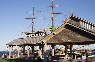
Clayton is a town in Jefferson County, New York, United States. The population was 5,153 at the 2010 census. The town is named after John M. Clayton, a federal political leader from Delaware.

Dunboy Castle is a ruined castle on the Beara Peninsula in south-west Ireland near the town of Castletownbere. It was a stronghold of the O'Sullivan Bere, a Gaelic clan leader and 'Chief of Dunboy', and was built to guard and defend the harbour of Berehaven. Its presence enabled O'Sullivan Bere to control the sea fisheries off the Irish coast and collect taxes from Irish and continental European fishing vessels sheltering in the haven. It was also a centre for the import/export trade to and from the continent. Today, much of the castle is destroyed but the ruins are open to the public.
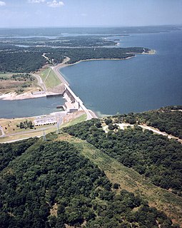
Lake Eufaula, sometimes referred to as Eufaula Lake, is a reservoir in Oklahoma. It is located on the Canadian River, 27 mi (43 km) upstream from its confluence with the Arkansas River and near the town of Eufaula. The lake covers parts of McIntosh County, Pittsburg, Haskell and Okmulgee counties and drains 47,522 square miles (123,080 km2). Water sources include the Canadian, North Fork Canadian and Deep Fork rivers. It is the largest-capacity lake in the state of Oklahoma with a volume of 2,099,000 acre feet (2.589×10⁹ m3), a surface area of 102,000 acres (410 km2) and 600 miles (970 km) of shoreline.
The Prince Albert Mountains are a major mountain group in Antarctica over 320 km (200 mi) long. Located in Victoria Land, they run north–south between the Priestley and Ferrar glaciers.

Soldier Hollow is a cross-country ski venue located at the mouth of a hollow of the same name about 53 miles (85 km) southeast of Salt Lake City in Wasatch Mountain State Park in northwestern Wasatch County, Utah, United States. The venue was created for the 2002 Winter Olympics, and during the games it hosted the biathlon, cross-country skiing, and the cross country skiing portion of the Nordic combined events. Since hosting the Olympics, it has been developed as a cross-country skiing, tubing, and snowshoeing venue, while featuring mountain biking and golfing in the summer. On May 1, 2016, the venue operation contract transferred from the Soldier Hollow Legacy Foundation to the Utah Olympic Legacy Foundation, which owns and operates several Olympic and Paralympic legacy venues elsewhere in the state.
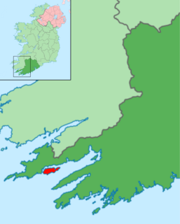
Bere Island (Irish: Oiléan Béarra, meaning "bear island", although officially called An tOileán Mór meaning "the big island") is an island off the Beara Peninsula in County Cork, Ireland. It is roughly 10 km x 3 km in dimension, with an area of 17.68 km², and, as of 2012, had a population of between 210 and 220 people.

Salem Harbor is a harbor in northeastern Massachusetts spanning an area north and south of Salem. Historically the Salem Harbor was the site of one of the major international ports in the colonies. During the American Revolutionary War, merchant ships were enlisted as privateers, an important role to augment the ill-prepared Continental Navy. In 1790, Salem Harbor was a world-famous seaport and sixth-largest in the United States of America. Now the harbor is used for commercial and recreational purposes and the Salem Maritime National Historic Site is very popular with tourists from around the world.

Hillarys Boat Harbour is a marina and tourist precinct located in Hillarys, north of Perth, Western Australia and on the Indian Ocean.
Hope Island is a suburb of the City of Gold Coast, Queensland, Australia. The town of Boykambil is within the suburb. The town of Santa Barbara is within the suburb. At the 2016 Census, Hope Island had a population of 11,186. Hope Island is close to both the Gold Coast beaches and Brisbane city.

Misquamicut State Beach is a seaside public recreation area in the town of Westerly, Rhode Island. It occupies a portion of Misquamicut Beach, a 3-mile-long (4.8 km) barrier island that extends westward from Weekapaug to Watch Hill and separates Winnapaug Pond from the Atlantic Ocean. The state beach covers 51 acres (21 ha) and features a large beach pavilion with multiple public facilities.

Cobb Island is a small island located at the confluence of the Potomac and Wicomico rivers in southern Charles County, Maryland, United States. It is located approximately 45 miles (72 km) south of Washington, and is considered to be within the Washington, D.C. MSA. Cobb Island is separated from the mainland by Neale Sound and connected to it by a 0.11-mile-long (180 m) fixed bridge carrying Maryland Route 254.

Sanctuary Cove is a gated community and town in the suburb of Hope Island in the City of Gold Coast, Queensland, Australia. It is completely self-contained residential environment with its own shopping centre and entertainment facilities, with the addition of many of the facilities of a holiday resort, such as boating marinas and golf courses. It was the second of such developments in Australia and is notable for its impact in planning legislation in Queensland to allow it to proceed.

Rerrin is the main village on Bere Island, within County Cork in Ireland. The village is located on the north of the island and is next to the sheltered mooring of Lawrence Cove. It is also the name of the townland surrounding the village. Historical records list Rurryne in the Calendar of Patent Rolls of James I dated 1611.

Sovereign Harbour is a development of the beachland in the seaside resort of Eastbourne, to the east of the town centre. Opened in 1993 and formerly known as The Crumbles, the marina now consists of five separate harbours,, a retail park and several housing projects with both permanent and holiday properties. Sovereign Harbour is Northern Europe’s largest composite marina complex.

The former Arrowhead State Park, now known as the Arrowhead Area at Lake Eufaula State Park is a 2,200-acre (8.9 km2) Oklahoma state park area located in northern Pittsburg County, Oklahoma on a peninsula of Eufaula Lake. It is located near the city of Canadian, Oklahoma. Eufaula is one of the largest man-made lakes in the southwest. Arrowhead State Park features 100 tent sites and 91 total RV sites. The park also offers picnic shelters, a marina, playgrounds, trails, miniature golf course, swimming area, mountain biking, equestrian campground, stables, and 25 miles (40 km) of equestrian trails. Group camps with a kitchen and bunkhouses are available and can sleep up to 144 people. Area 51 Marina, which also offers a restaurant, is also located at the park in the Echo Ridge area.

Tofino is a town of approximately 1,932 residents on the west coast of Vancouver Island in the Canadian province of British Columbia. The District of Tofino is located at the western terminus of Highway 4 on the tip of the Esowista Peninsula at the southern edge of Clayoquot Sound. It is situated in the traditional territory of the Tla-o-qui-aht First Nations.
MOBRO Marine, Inc. is an American marine and construction equipment business headquartered in Green Cove Springs, Florida. It was established in 1962 as Moody Brothers of Jacksonville by Maxey Dell Moody Jr. as a sister company of M. D. Moody & Sons, Inc. to handle the marine business and rental of large construction equipment. In 1992, as the result of a corporate spinoff of the Pablo Creek Marina and other assets it was incorporated and renamed as MOBRO Marine, Inc.

Wirrina Cove is a locality and holiday resort on the Fleurieu Peninsula, South Australia. It is located between the coastal towns of Second Valley and Normanville on Yankalilla Bay. The holiday resort was developed from around 1972, and is located about 90 kilometres (56 mi) south of Adelaide.
Magusaiai is an island of the Shortland Islands archipelago, located in the Western Province of the Solomon Islands is the Pacific Ocean. The estimated terrain elevation above sea level is some 14 metres.
References
- ↑ "Lawrence Cove Marina". bereisland.net. Bere Island Project Group. Retrieved 7 November 2018.CS1 maint: discouraged parameter (link)
- ↑ "Bere Island Lodge, Lawrence's Cove". bereislandlodge.com. Bere Island Lodge. Retrieved 7 November 2018.
[Lawrence Cove] was where the British Army kept its supply of coal for its barracks and quarters
CS1 maint: discouraged parameter (link) - ↑ "Services - Marina Winter Yacht Storage". lawrencecovemarina.ie. Lawrence Cove Marina. Retrieved 7 November 2018.CS1 maint: discouraged parameter (link)
- 1 2 "Lawrence Cove Marina". bereisland.net. Bere Island Project Group. Retrieved 7 November 2018.CS1 maint: discouraged parameter (link)
Coordinates: 51°38′N9°49′W / 51.633°N 9.817°W
| | This geographical article about County Cork is a stub. You can help Wikipedia by expanding it. |