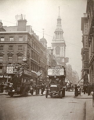
Cheapside is a street in the City of London, the historic and modern financial centre of London, England, which forms part of the A40 London to Fishguard road. It links St Martin's Le Grand with Poultry. Near its eastern end at Bank junction, where it becomes Poultry, is Mansion House, the Bank of England, and Bank station. To the west is St Paul's Cathedral, St Paul's tube station and square.
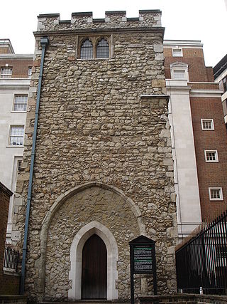
All Hallows Staining was a Church of England church located at the junction of Mark Lane and Dunster Court in the north-eastern corner of Langbourn ward in the City of London, England, close to Fenchurch Street railway station. All that remains of the church is the tower, built around AD 1320 as part of the second church on the site. Use of the grounds around the church is the subject of the Allhallows Staining Church Act 2010.
The EC postcode area, also known as the London EC postal area, is a group of postcode districts in central London, England. It includes almost all of the City of London and parts of the London boroughs of Islington, Camden, Hackney, Tower Hamlets and Westminster. The area covered is of very high density development. Deliveries for the EC postcode area are made from Mount Pleasant Mail Centre.

The Wood Street Compter was a small prison within the City of London in England. It was primarily a debtors' prison, and also held people accused of such misdemeanours as public drunkenness, although some wealthier prisoners were able to obtain alcohol through bribery. The prison was built and opened in 1555, replacing the earlier Bread Street Compter, from which many prisoners were transferred. Wood Street was closed and replaced by Giltspur Street Compter in 1791.
Ironmonger Lane is a narrow one-way street in the City of London running southbound between Gresham Street and Cheapside.

Gresham Street in the City of London is named after the English merchant and financier Thomas Gresham.

St. Martin's Le Grand is a former liberty within the City of London, and is the name of a street north of Newgate Street and Cheapside and south of Aldersgate Street. It forms the southernmost section of the A1 road. For many years St. Martin's Le Grand was "often used as a synonym for the chief postal authorities, as Scotland Yard is used to designate the police", the headquarters of the General Post Office having been there from 1829-1984.

All Hallows, Honey Lane was a parish church in the City of London, England. Of medieval origin, it was destroyed in the Great Fire of London in 1666 and not rebuilt; the site became part of Honey Lane Market, which was in turn partially cleared to make way for the City of London School in the 19th century. Much of the area was destroyed during the bombing in World War II and has been redeveloped. The name Honey Lane is retained in a nearby walkway.
Chancery Lane is a one-way street that forms part of the western boundary of the City of London. The east side of the street is entirely within the City, whilst the west side is in the City of Westminster south of Carey Street and the London Borough of Camden north of that street. The route originated as a 'new lane' created by the Knights Templar from their original 'old Temple' on the site of the present Southampton Buildings on Holborn, in order to access to their newly acquired property to the south of Fleet Street sometime before 1161.

Wood Street is a street in the City of London, the historic centre and primary financial district of London. It originates in the south at a junction with Cheapside; heading north it crosses Gresham Street and London Wall. The northernmost end runs alongside The Postern, part of the Barbican estate, stopping at Andrewes House. Today Wood Street lies within the wards of Bassishaw and Cheap.

St Michael-le-Querne, also called St Michael ad Bladum, was a parish church in the Farringdon Within Ward in the City of London. It was destroyed in the Great Fire of London of 1666 and not rebuilt. The name is apparently a reference to a quern-stone as there was a corn market in the churchyard.

Maiden Lane is a street in Covent Garden, London, that runs from Bedford Street in the west to Southampton Street in the east. The painter J. M. W. Turner was born on this street in 1775.

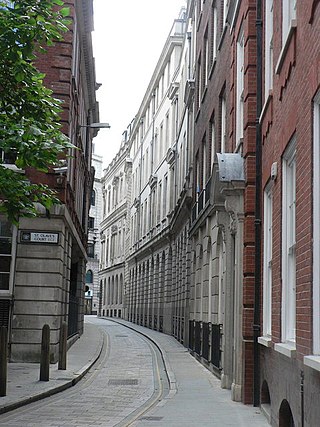
Russia Row is a street in the City of London that runs between Milk Street and Trump Street on the northern side of the former Honey Lane Market. Russia Court, formerly Robin Hood Court, the home of the Russia Company, was once located on the northern side of the street and the City of London School on the south side. The street is thought to have received its name around 1804, shortly before Russia decided to enter the Napoleonic Wars on the same side as Britain. It was damaged by German bombing during the Second World War and has since been completely rebuilt.

Trump Street is a street in the City of London that was originally known as Trumpadere Street, probably after the trumpet or horn makers who once worked there or in the adjacent Trump Alley. It was built after the Great Fire of London (1666) but completely destroyed by bombing during the Second World War and has since been entirely rebuilt.

Blossom's Inn was a tavern which stood in Lawrence Lane in the City of London from the 14th century until 1855. It became a substantial coaching inn and was used as a staging post by carriers of goods. In the 19th century, the lease was bought and it became the parcel depot of the Great Eastern Railway. Its name was used for a major property development at the end of the 20th century and the site is now part of the large complex of 30 Gresham Street.

30 Gresham Street is an office building in Gresham Street in the City of London of 386,000 sq ft developed by Land Securities in 2002-03 and occupied by Commerzbank, Investec Bank and Rathbones Group. When built, it was described as "the biggest speculative office development in the capital." The building is bounded in the south by Russia Row and Trump Street, in the east by Lawrence Lane, and in the west by Milk Street. It is on the site of the former Blossom's Inn as well as a number of other small alleys and courts such as Robin Hood Court, Russia Court, Mumford Court and Castle Court.

The Swan with Two Necks was a coaching inn in the City of London that, until the arrival of the railways, was one of the principal departure points for travel to the north of England from London. Its site was given over in the early 1860s to a goods and parcels depot for a firm of railway agents and carriers.

The Bull and Mouth Inn was a coaching inn in the City of London that dated from before the Great Fire of London in 1666. It was located between Bull and Mouth Street in the north and Angel Street in the south. It was once an important arrival and departure point for coaches from all over Britain, but particularly for the north of England and Scotland. It became the Queen's Hotel in 1830 but was demolished in 1887 or 1888 when new post office buildings were built in St Martin's Le Grand.

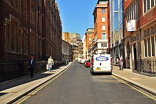
Milk Street in the City of London, England, was the site of London's medieval milk market. It was the location of the parish church of St Mary Magdalen which was destroyed in the Great Fire of London in 1666 and then of Honey Lane Market and the City of London School. The street was seriously damaged by German bombing during the Second World War and has since been completely rebuilt. Nothing remains of its former buildings.

Honey Lane Market was an historic market near Cheapside in the City of London.
