
The City of London is a city, ceremonial county and local government district that contains the historic centre and constitutes, alongside Canary Wharf, the primary central business district (CBD) of London. It constituted most of London from its settlement by the Romans in the 1st century AD to the Middle Ages, but the modern area named London has since grown far beyond the City of London boundary. The City is now only a small part of the metropolis of Greater London, though it remains a notable part of central London. Administratively, the City of London is not one of the London boroughs, a status reserved for the other 32 districts. It is also a separate ceremonial county, being an enclave surrounded by Greater London, and is the smallest ceremonial county in the United Kingdom.

Kingston upon Thames is a town in the Royal Borough of Kingston upon Thames, southwest London, England. It is situated on the River Thames and 10 miles (16 km) southwest of Charing Cross. It is notable as the ancient market town in which Saxon kings were crowned and today is the administrative centre of the Royal Borough.

Bermondsey is a district in southeast London, part of the London Borough of Southwark, England, 2.5 miles (4.0 km) southeast of Charing Cross. To the west of Bermondsey lies Southwark, to the east Rotherhithe and Deptford, to the south Walworth and Peckham, and to the north is Wapping across the River Thames. It lies within the historic county boundaries of Surrey. During the Industrial Revolution Bermondsey became a centre for manufacturing, particularly in relation to tanning. More recently it has experienced regeneration including warehouse conversions to flats and the provision of new transport links.

City Hall is a building in Southwark, London which previously served as the headquarters of the Greater London Authority (GLA) between July 2002 and December 2021. It is located in the London Borough of Southwark, on the south bank of the River Thames near Tower Bridge. In June 2020, the Greater London Authority started a consultation on proposals to vacate City Hall and move to The Crystal, a GLA-owned property in Newham, at the end of 2021. The decision was confirmed on 3 November 2020 and the GLA vacated City Hall on 2 December 2021. The Southwark location is ultimately owned by the government of Kuwait.

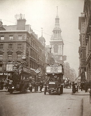
Cheapside is a street in the City of London, the historic and modern financial centre of London, which forms part of the A40 London to Fishguard road. It links St. Martin's Le Grand with Poultry. Near its eastern end at Bank junction, where it becomes Poultry, is Mansion House, the Bank of England, and Bank station. To the west is St. Paul's Cathedral, St Paul's tube station and square.

Cannon Street is a road in the City of London, the historic nucleus of London and its modern financial centre. It runs roughly parallel with the River Thames, about 250 metres (820 ft) north of it, in the south of the City.

Gracechurch Street is a main road in the City of London, the historic and financial centre of London, which is designated the A1213.

Eastcheap is a street in central London that is a western continuation of Great Tower Street towards Monument junction. Its name derives from cheap, the Old English word for market, with the prefix 'East' distinguishing it from Westcheap, another former market street that today is called Cheapside.

Cornhill is a ward and street in the City of London, the historic nucleus and financial centre of modern London. The street runs between Bank Junction and Leadenhall Street.
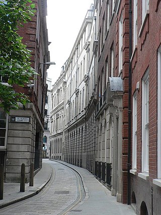
Ironmonger Lane is a narrow one-way street in the City of London running southbound between Gresham Street and Cheapside.

Gresham Street in the City of London is named after the English merchant and financier Thomas Gresham.

Lime Street is a minor road in the City of London between Fenchurch Street to the south and Leadenhall Street to the north. Its name comes from the lime burners who once sold lime from there for use in construction.
Cordwainer is a small, almost rectangular-shaped ward in the City of London. It is named after the cordwainers, the professional shoemakers who historically lived and worked in this particular area of London; there is a Livery Company for the trade — the Worshipful Company of Cordwainers. The ward is sometimes referred to as the "Cordwainers' ward".

Queen Victoria Street, named after the British monarch who reigned from 1837 to 1901, is a street in London which runs east by north from its junction with New Bridge Street and Victoria Embankment in the Castle Baynard ward of the City of London, along a section that divides the wards of Queenhithe and Bread Street, then lastly through the middle of Cordwainer ward, until it reaches Mansion House Street at Bank junction. Beyond Bank junction, the street continues north-east as Threadneedle Street which joins Bishopsgate. Other streets linked to Queen Victoria Street include Puddle Dock, Cannon Street, Walbrook and Poultry.

Byward Street is a road in the City of London, the historic and financial centre of London. It forms part of the A3211 route and, if travelling eastward, is a short continuation of Lower Thames Street from a junction with Great Tower Street, to Tower Hill. It is located within the City ward of Tower.
The 2012 Olympic Marathon Course is that of both the men's and women's marathon races at the 2012 Olympic and Paralympic Games in London.

Thames Street, divided into Lower and Upper Thames Street, is a road in the City of London, the historic and financial centre of London. It forms part of the busy A3211 route from Tower Hill to Westminster. The London Bridge underpass marks the divide between Upper and Lower Thames Street, with Lower to the east and Upper to the west.

Lawrence Lane is a street in the City of London that runs from Trump Street in the south to Gresham Street in the north. Its final section in the north is pedestrianised. An alley also joins it to King Street in the north. It once ran south to join Cheapside but that end was blocked following post-Second World War rebuilding. It was known as St Lawrence Lane from the 13th to the 18th centuries due to its proximity to the church of St Lawrence Jewry and until King Street was built was the main route from Cheapside to the London Guildhall.
